Saint-Martin-Valmeroux
| Saint-Martin-Valmeroux | ||
|---|---|---|
| Commune | ||
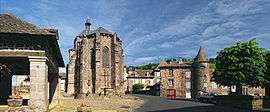 A panoramic view within Saint-Martin-Valmeroux | ||
| ||
 Saint-Martin-Valmeroux Location within Auvergne-Rhône-Alpes region  Saint-Martin-Valmeroux | ||
| Coordinates: 45°07′06″N 2°25′33″E / 45.1183°N 2.4258°ECoordinates: 45°07′06″N 2°25′33″E / 45.1183°N 2.4258°E | ||
| Country | France | |
| Region | Auvergne-Rhône-Alpes | |
| Department | Cantal | |
| Arrondissement | Mauriac | |
| Canton | Mauriac | |
| Intercommunality | Pays de Salers | |
| Government | ||
| • Mayor (2008–2014) | Christian Fournier | |
| Area1 | 25.92 km2 (10.01 sq mi) | |
| Population (2008)2 | 856 | |
| • Density | 33/km2 (86/sq mi) | |
| Time zone | UTC+1 (CET) | |
| • Summer (DST) | UTC+2 (CEST) | |
| INSEE/Postal code | 15202 /15140 | |
| Elevation |
609–963 m (1,998–3,159 ft) (avg. 650 m or 2,130 ft) | |
|
1 French Land Register data, which excludes lakes, ponds, glaciers > 1 km2 (0.386 sq mi or 247 acres) and river estuaries. 2 Population without double counting: residents of multiple communes (e.g., students and military personnel) only counted once. | ||

Saint-Martin-Valmeroux is a commune in the Cantal department in south-central France.
Geography
The Maronne river flows through the middle of the commune and crosses the village of Saint-Martin-Valmeroux.
Population
| Historical population | ||
|---|---|---|
| Year | Pop. | ±% |
| 1962 | 1,157 | — |
| 1968 | 1,145 | −1.0% |
| 1975 | 1,099 | −4.0% |
| 1982 | 1,009 | −8.2% |
| 1990 | 1,012 | +0.3% |
| 1999 | 911 | −10.0% |
| 2008 | 856 | −6.0% |
See also
References
| Wikimedia Commons has media related to Saint-Martin-Valmeroux. |
This article is issued from
Wikipedia.
The text is licensed under Creative Commons - Attribution - Sharealike.
Additional terms may apply for the media files.