Labrousse
| Labrousse | |
|---|---|
| Commune | |
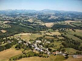 An aerial view of Labrousse | |
 Labrousse Location within Auvergne-Rhône-Alpes region  Labrousse | |
| Coordinates: 44°51′26″N 2°32′34″E / 44.8572°N 2.5428°ECoordinates: 44°51′26″N 2°32′34″E / 44.8572°N 2.5428°E | |
| Country | France |
| Region | Auvergne-Rhône-Alpes |
| Department | Cantal |
| Arrondissement | Aurillac |
| Canton | Vic-sur-Cère |
| Intercommunality | CA Bassin d'Aurillac |
| Government | |
| • Mayor (2008–2014) | Gérard Pradal |
| Area1 | 19.86 km2 (7.67 sq mi) |
| Population (2008)2 | 388 |
| • Density | 20/km2 (51/sq mi) |
| Time zone | UTC+1 (CET) |
| • Summer (DST) | UTC+2 (CEST) |
| INSEE/Postal code | 15085 /15130 |
| Elevation |
467–850 m (1,532–2,789 ft) (avg. 800 m or 2,600 ft) |
|
1 French Land Register data, which excludes lakes, ponds, glaciers > 1 km2 (0.386 sq mi or 247 acres) and river estuaries. 2 Population without double counting: residents of multiple communes (e.g., students and military personnel) only counted once. | |
Labrousse is a commune in the Cantal department in south-central France.
Population
| Historical population | ||
|---|---|---|
| Year | Pop. | ±% |
| 1831 | 1,100 | — |
| 1836 | 819 | −25.5% |
| 1841 | 861 | +5.1% |
| 1846 | 838 | −2.7% |
| 1851 | 845 | +0.8% |
| 1856 | 729 | −13.7% |
| 1861 | 777 | +6.6% |
| 1866 | 780 | +0.4% |
| 1871 | 792 | +1.5% |
| 1876 | 761 | −3.9% |
| 1881 | 676 | −11.2% |
| 1886 | 654 | −3.3% |
| 1891 | 689 | +5.4% |
| 1896 | 642 | −6.8% |
| 1901 | 629 | −2.0% |
| 1906 | 583 | −7.3% |
| 1911 | 539 | −7.5% |
| 1921 | 510 | −5.4% |
| 1926 | 512 | +0.4% |
| 1931 | 506 | −1.2% |
| 1936 | 479 | −5.3% |
| 1946 | 472 | −1.5% |
| 1954 | 470 | −0.4% |
| 1962 | 414 | −11.9% |
| 1968 | 395 | −4.6% |
| 1975 | 397 | +0.5% |
| 1982 | 445 | +12.1% |
| 1990 | 432 | −2.9% |
| 1999 | 379 | −12.3% |
| 2008 | 388 | +2.4% |
See also
References
| Wikimedia Commons has media related to Labrousse (Cantal). |
This article is issued from
Wikipedia.
The text is licensed under Creative Commons - Attribution - Sharealike.
Additional terms may apply for the media files.