Montboudif
| Montboudif | |
|---|---|
| Commune | |
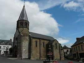 The church of Sainte-Anne, in Montboudif | |
 Montboudif Location within Auvergne-Rhône-Alpes region  Montboudif | |
| Coordinates: 45°22′20″N 2°43′56″E / 45.3722°N 2.7322°ECoordinates: 45°22′20″N 2°43′56″E / 45.3722°N 2.7322°E | |
| Country | France |
| Region | Auvergne-Rhône-Alpes |
| Department | Cantal |
| Arrondissement | Saint-Flour |
| Canton | Riom-ès-Montagnes |
| Intercommunality | Cézallier |
| Government | |
| • Mayor (2008–2014) | Lucien Bonhomme |
| Area1 | 20.42 km2 (7.88 sq mi) |
| Population (2008)2 | 208 |
| • Density | 10/km2 (26/sq mi) |
| Time zone | UTC+1 (CET) |
| • Summer (DST) | UTC+2 (CEST) |
| INSEE/Postal code | 15129 /15190 |
| Elevation |
580–1,111 m (1,903–3,645 ft) (avg. 900 m or 3,000 ft) |
|
1 French Land Register data, which excludes lakes, ponds, glaciers > 1 km2 (0.386 sq mi or 247 acres) and river estuaries. 2 Population without double counting: residents of multiple communes (e.g., students and military personnel) only counted once. | |
Montboudif is a commune in the Cantal department in south-central France.
Geography
The river Rhue forms most of the commune's southern border.
Population
| Historical population | ||
|---|---|---|
| Year | Pop. | ±% |
| 1962 | 497 | — |
| 1968 | 512 | +3.0% |
| 1975 | 339 | −33.8% |
| 1982 | 311 | −8.3% |
| 1990 | 251 | −19.3% |
| 1999 | 231 | −8.0% |
| 2008 | 208 | −10.0% |
Personalities
It was the birthplace of Georges Pompidou (1911-1974), President of France.
See also
References
| Wikimedia Commons has media related to Montboudif. |
This article is issued from
Wikipedia.
The text is licensed under Creative Commons - Attribution - Sharealike.
Additional terms may apply for the media files.