Nieudan
| Nieudan | |
|---|---|
| Commune | |
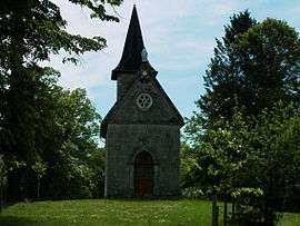 Chapel of Puy Rachat | |
 Nieudan Location within Auvergne-Rhône-Alpes region  Nieudan | |
| Coordinates: 44°59′05″N 2°14′38″E / 44.9847°N 2.2439°ECoordinates: 44°59′05″N 2°14′38″E / 44.9847°N 2.2439°E | |
| Country | France |
| Region | Auvergne-Rhône-Alpes |
| Department | Cantal |
| Arrondissement | Aurillac |
| Canton | Saint-Paul-des-Landes |
| Intercommunality | Entre 2 Lacs |
| Government | |
| • Mayor (2014–2020) | Vincent Roquette |
| Area1 | 12.4 km2 (4.8 sq mi) |
| Population (2012)2 | 109 |
| • Density | 8.8/km2 (23/sq mi) |
| Time zone | UTC+1 (CET) |
| • Summer (DST) | UTC+2 (CEST) |
| INSEE/Postal code | 15143 /15150 |
| Elevation |
479–626 m (1,572–2,054 ft) (avg. 496 m or 1,627 ft) |
|
1 French Land Register data, which excludes lakes, ponds, glaciers > 1 km2 (0.386 sq mi or 247 acres) and river estuaries. 2 Population without double counting: residents of multiple communes (e.g., students and military personnel) only counted once. | |
Nieudan is a commune in the département of Cantal in south-central France.
Population
| Historical population | ||
|---|---|---|
| Year | Pop. | ±% |
| 1962 | 134 | — |
| 1968 | 115 | −14.2% |
| 1975 | 105 | −8.7% |
| 1982 | 99 | −5.7% |
| 1990 | 97 | −2.0% |
| 1999 | 105 | +8.2% |
| 2006 | 106 | +1.0% |
| 2012 | 109 | +2.8% |
See also
References
| Wikimedia Commons has media related to Nieudan. |
This article is issued from
Wikipedia.
The text is licensed under Creative Commons - Attribution - Sharealike.
Additional terms may apply for the media files.