Saint-Julien-de-Toursac
| Saint-Julien-de-Toursac | |
|---|---|
| Commune | |
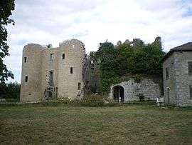 Ruins of the Chateau of Naucaze | |
 Saint-Julien-de-Toursac Location within Auvergne-Rhône-Alpes region  Saint-Julien-de-Toursac | |
| Coordinates: 44°46′29″N 2°12′37″E / 44.7747°N 2.2103°ECoordinates: 44°46′29″N 2°12′37″E / 44.7747°N 2.2103°E | |
| Country | France |
| Region | Auvergne-Rhône-Alpes |
| Department | Cantal |
| Arrondissement | Aurillac |
| Canton | Maurs |
| Intercommunality | Pays de Maurs |
| Government | |
| • Mayor (2008–2014) | Claude Maniol |
| Area1 | 9.44 km2 (3.64 sq mi) |
| Population (2008)2 | 141 |
| • Density | 15/km2 (39/sq mi) |
| Time zone | UTC+1 (CET) |
| • Summer (DST) | UTC+2 (CEST) |
| INSEE/Postal code | 15194 /15600 |
| Elevation |
270–582 m (886–1,909 ft) (avg. 498 m or 1,634 ft) |
|
1 French Land Register data, which excludes lakes, ponds, glaciers > 1 km2 (0.386 sq mi or 247 acres) and river estuaries. 2 Population without double counting: residents of multiple communes (e.g., students and military personnel) only counted once. | |
Saint-Julien-de-Toursac is a commune in the Cantal department in south-central France.
Population
| Historical population | ||
|---|---|---|
| Year | Pop. | ±% |
| 1962 | 154 | — |
| 1968 | 183 | +18.8% |
| 1975 | 148 | −19.1% |
| 1982 | 115 | −22.3% |
| 1990 | 116 | +0.9% |
| 1999 | 105 | −9.5% |
| 2008 | 141 | +34.3% |
See also
References
| Wikimedia Commons has media related to Saint-Julien-de-Toursac. |
This article is issued from
Wikipedia.
The text is licensed under Creative Commons - Attribution - Sharealike.
Additional terms may apply for the media files.