Reilhac, Cantal
| Reilhac | |
|---|---|
| Commune | |
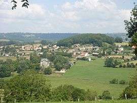 A general view of Reilhac | |
 Reilhac Location within Auvergne-Rhône-Alpes region  Reilhac | |
| Coordinates: 44°58′28″N 2°25′19″E / 44.9744°N 2.4219°ECoordinates: 44°58′28″N 2°25′19″E / 44.9744°N 2.4219°E | |
| Country | France |
| Region | Auvergne-Rhône-Alpes |
| Department | Cantal |
| Arrondissement | Aurillac |
| Canton | Naucelles |
| Intercommunality | CA Bassin d'Aurillac |
| Government | |
| • Mayor (2008–2014) | Jean-Pierre Picard |
| Area1 | 8.89 km2 (3.43 sq mi) |
| Population (2008)2 | 1,013 |
| • Density | 110/km2 (300/sq mi) |
| Time zone | UTC+1 (CET) |
| • Summer (DST) | UTC+2 (CEST) |
| INSEE/Postal code | 15160 /15250 |
| Elevation |
582–867 m (1,909–2,844 ft) (avg. 636 m or 2,087 ft) |
|
1 French Land Register data, which excludes lakes, ponds, glaciers > 1 km2 (0.386 sq mi or 247 acres) and river estuaries. 2 Population without double counting: residents of multiple communes (e.g., students and military personnel) only counted once. | |
Reilhac is a commune in the Cantal department in south-central France.
Population
| Historical population | ||
|---|---|---|
| Year | Pop. | ±% |
| 1962 | 419 | — |
| 1968 | 487 | +16.2% |
| 1975 | 814 | +67.1% |
| 1982 | 768 | −5.7% |
| 1990 | 901 | +17.3% |
| 1999 | 957 | +6.2% |
| 2008 | 1,013 | +5.9% |
See also
References
| Wikimedia Commons has media related to Reilhac (Cantal). |
This article is issued from
Wikipedia.
The text is licensed under Creative Commons - Attribution - Sharealike.
Additional terms may apply for the media files.