Laroquebrou
| Laroquebrou | ||
|---|---|---|
| Commune | ||
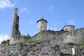 The Chateau de Laroquebrou | ||
| ||
 Laroquebrou Location within Auvergne-Rhône-Alpes region  Laroquebrou | ||
| Coordinates: 44°58′10″N 2°11′33″E / 44.9694°N 2.1925°ECoordinates: 44°58′10″N 2°11′33″E / 44.9694°N 2.1925°E | ||
| Country | France | |
| Region | Auvergne-Rhône-Alpes | |
| Department | Cantal | |
| Arrondissement | Aurillac | |
| Canton | Saint-Paul-des-Landes | |
| Intercommunality | Entre 2 Lacs en Châtaigneraie | |
| Government | ||
| • Mayor (2008–2014) | Guy Blandino | |
| Area1 | 17.15 km2 (6.62 sq mi) | |
| Population (2008)2 | 929 | |
| • Density | 54/km2 (140/sq mi) | |
| Time zone | UTC+1 (CET) | |
| • Summer (DST) | UTC+2 (CEST) | |
| INSEE/Postal code | 15094 /15150 | |
| Elevation |
429–693 m (1,407–2,274 ft) (avg. 440 m or 1,440 ft) | |
|
1 French Land Register data, which excludes lakes, ponds, glaciers > 1 km2 (0.386 sq mi or 247 acres) and river estuaries. 2 Population without double counting: residents of multiple communes (e.g., students and military personnel) only counted once. | ||

Laroquebrou is a commune in the Cantal department in south-central France.
Population
| Historical population | ||
|---|---|---|
| Year | Pop. | ±% |
| 1962 | 1,237 | — |
| 1968 | 1,193 | −3.6% |
| 1975 | 1,014 | −15.0% |
| 1982 | 1,023 | +0.9% |
| 1990 | 1,048 | +2.4% |
| 1999 | 1,080 | +3.1% |
| 2008 | 929 | −14.0% |
See also
References
External links
![]()
This article is issued from
Wikipedia.
The text is licensed under Creative Commons - Attribution - Sharealike.
Additional terms may apply for the media files.