Calvinet
| Calvinet | ||
|---|---|---|
| Commune | ||
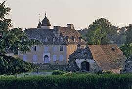 Chateau of la Mothe | ||
| ||
 Calvinet Location within Auvergne-Rhône-Alpes region  Calvinet | ||
| Coordinates: 44°43′07″N 2°21′30″E / 44.7186°N 2.3583°ECoordinates: 44°43′07″N 2°21′30″E / 44.7186°N 2.3583°E | ||
| Country | France | |
| Region | Auvergne-Rhône-Alpes | |
| Department | Cantal | |
| Arrondissement | Aurillac | |
| Canton | Arpajon-sur-Cère | |
| Intercommunality | Montsalvy | |
| Government | ||
| • Mayor (2008–2014) | Edouard De Bonnafos | |
| Area1 | 13.73 km2 (5.30 sq mi) | |
| Population (2008)2 | 471 | |
| • Density | 34/km2 (89/sq mi) | |
| Time zone | UTC+1 (CET) | |
| • Summer (DST) | UTC+2 (CEST) | |
| INSEE/Postal code | 15027 /15340 | |
| Elevation |
452–742 m (1,483–2,434 ft) (avg. 600 m or 2,000 ft) | |
|
1 French Land Register data, which excludes lakes, ponds, glaciers > 1 km2 (0.386 sq mi or 247 acres) and river estuaries. 2 Population without double counting: residents of multiple communes (e.g., students and military personnel) only counted once. | ||

Calvinet is a commune in the Cantal department in south-central France.
Population
| Historical population | ||
|---|---|---|
| Year | Pop. | ±% |
| 1962 | 521 | — |
| 1968 | 524 | +0.6% |
| 1975 | 491 | −6.3% |
| 1982 | 408 | −16.9% |
| 1990 | 404 | −1.0% |
| 1999 | 432 | +6.9% |
| 2008 | 471 | +9.0% |
See also
References
| Wikimedia Commons has media related to Calvinet. |
This article is issued from
Wikipedia.
The text is licensed under Creative Commons - Attribution - Sharealike.
Additional terms may apply for the media files.