Arrondissement of Saint-Flour
| Saint-Flour | |
|---|---|
| Arrondissement | |
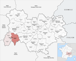 Location of the arrondissement in Auvergne-Rhône-Alpes | |
| Country | France |
| Region | Auvergne-Rhône-Alpes |
| Department | Cantal |
| Communes | 98 |
| Subprefecture | Saint-Flour |
| Area¹ | |
| • Total | 2,511 km2 (970 sq mi) |
| Population (2013) | |
| • Total | 38,125 |
| • Density | 15/km2 (39/sq mi) |
| ¹ French Land Register data, which exclude lakes, ponds, and glaciers larger than 1 km² as well as the estuaries of rivers. | |
The arrondissement of Saint-Flour is an arrondissement of France in the Cantal department in the Auvergne-Rhône-Alpes region. It has 98 communes.
Composition
Cantons
The cantons of the arrondissement of Saint-Flour are:
Communes
The communes of the arrondissement of Saint-Flour, and their INSEE codes, are:
- Albepierre-Bredons (15025)
- Allanche (15001)
- Alleuze (15002)
- Andelat (15004)
- Anglards-de-Saint-Flour (15005)
- Anterrieux (15007)
- Auriac-l'Église (15013)
- Bonnac (15022)
- Brezons (15026)
- Celoux (15032)
- Cézens (15033)
- Chaliers (15034)
- Chanterelle (15040)
- La Chapelle-d'Alagnon (15041)
- La Chapelle-Laurent (15042)
- Charmensac (15043)
- Chaudes-Aigues (15045)
- Chazelles (15048)
- Cheylade (15049)
- Le Claux (15050)
- Clavières (15051)
- Coltines (15053)
- Condat (15054)
- Coren (15055)
- Cussac (15059)
- Deux-Verges (15060)
- Dienne (15061)
- Espinasse (15065)
- Ferrières-Saint-Mary (15069)
- Fridefont (15073)
- Gourdièges (15077)
- Jabrun (15078)
- Joursac (15080)
- Lacapelle-Barrès (15086)
- Landeyrat (15091)
- Lastic (15097)
- Laurie (15098)
- Laveissenet (15100)
- Laveissière (15101)
- Lavigerie (15102)
- Leyvaux (15105)
- Lieutadès (15106)
- Lorcières (15107)
- Lugarde (15110)
- Malbo (15112)
- Marcenat (15114)
- Marchastel (15116)
- Massiac (15119)
- Maurines (15121)
- Mentières (15125)
- Molèdes (15126)
- Molompize (15127)
- Montboudif (15129)
- Montchamp (15130)
- Montgreleix (15132)
- Murat (15138)
- Narnhac (15139)
- Neussargues en Pinatelle (15141)
- Neuvéglise-sur-Truyère (15142)
- Paulhac (15148)
- Paulhenc (15149)
- Peyrusse (15151)
- Pierrefort (15152)
- Pradiers (15155)
- Rageade (15158)
- Rézentières (15161)
- Roffiac (15164)
- Ruynes-en-Margeride (15168)
- Saint-Amandin (15170)
- Saint-Bonnet-de-Condat (15173)
- Sainte-Marie (15198)
- Saint-Flour (15187)
- Saint-Georges (15188)
- Saint-Martial (15199)
- Saint-Martin-sous-Vigouroux (15201)
- Saint-Mary-le-Plain (15203)
- Saint-Poncy (15207)
- Saint-Rémy-de-Chaudes-Aigues (15209)
- Saint-Saturnin (15213)
- Saint-Urcize (15216)
- Ségur-les-Villas (15225)
- Soulages (15229)
- Talizat (15231)
- Tanavelle (15232)
- Les Ternes (15235)
- Tiviers (15237)
- La Trinitat (15241)
- Ussel (15244)
- Vabres (15245)
- Val-d'Arcomie (15108)
- Valjouze (15247)
- Valuéjols (15248)
- Védrines-Saint-Loup (15251)
- Vernols (15253)
- Vèze (15256)
- Vieillespesse (15259)
- Villedieu (15262)
- Virargues (15263)
External links
This article is issued from
Wikipedia.
The text is licensed under Creative Commons - Attribution - Sharealike.
Additional terms may apply for the media files.