Le Claux
| Le Claux | |
|---|---|
| Commune | |
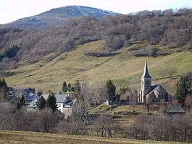 The church and surrounding buildings in Le Claux | |
 Le Claux Location within Auvergne-Rhône-Alpes region  Le Claux | |
| Coordinates: 45°09′38″N 2°42′22″E / 45.1606°N 2.7061°ECoordinates: 45°09′38″N 2°42′22″E / 45.1606°N 2.7061°E | |
| Country | France |
| Region | Auvergne-Rhône-Alpes |
| Department | Cantal |
| Arrondissement | Saint-Flour |
| Canton | Murat |
| Intercommunality | Pays de Gentiane |
| Government | |
| • Mayor (2008–2014) | Jacques Bergeron |
| Area1 | 28.07 km2 (10.84 sq mi) |
| Population (2008)2 | 217 |
| • Density | 7.7/km2 (20/sq mi) |
| Time zone | UTC+1 (CET) |
| • Summer (DST) | UTC+2 (CEST) |
| INSEE/Postal code | 15050 /15400 |
| Elevation |
994–1,780 m (3,261–5,840 ft) (avg. 1,037 m or 3,402 ft) |
|
1 French Land Register data, which excludes lakes, ponds, glaciers > 1 km2 (0.386 sq mi or 247 acres) and river estuaries. 2 Population without double counting: residents of multiple communes (e.g., students and military personnel) only counted once. | |
Le Claux is a commune in the Cantal department in south-central France. It is located in Auvergne, in the department of Cantal.
It is located in the Massif central, specifically in the monts du Cantal. Because of its location in between the mountains, snowfall is heavy, which has given it the nickname of "village de Neige (French for "village of snow").
Population
| Historical population | ||
|---|---|---|
| Year | Pop. | ±% |
| 1962 | 304 | — |
| 1968 | 405 | +33.2% |
| 1975 | 352 | −13.1% |
| 1982 | 341 | −3.1% |
| 1990 | 293 | −14.1% |
| 1999 | 260 | −11.3% |
| 2008 | 217 | −16.5% |
See also
References
| Wikimedia Commons has media related to Le Claux. |
This article is issued from
Wikipedia.
The text is licensed under Creative Commons - Attribution - Sharealike.
Additional terms may apply for the media files.