Fridefont
| Fridefont | ||
|---|---|---|
| Commune | ||
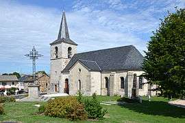 The church in Fridefont | ||
| ||
 Fridefont Location within Auvergne-Rhône-Alpes region  Fridefont | ||
| Coordinates: 44°54′07″N 3°05′15″E / 44.9019°N 3.0875°ECoordinates: 44°54′07″N 3°05′15″E / 44.9019°N 3.0875°E | ||
| Country | France | |
| Region | Auvergne-Rhône-Alpes | |
| Department | Cantal | |
| Arrondissement | Saint-Flour | |
| Canton | Neuvéglise | |
| Intercommunality | Caldaguès-Aubrac | |
| Government | ||
| • Mayor (2008–2014) | Michel Guilbot | |
| Area1 | 13.96 km2 (5.39 sq mi) | |
| Population (2008)2 | 114 | |
| • Density | 8.2/km2 (21/sq mi) | |
| Time zone | UTC+1 (CET) | |
| • Summer (DST) | UTC+2 (CEST) | |
| INSEE/Postal code | 15073 /15110 | |
| Elevation |
660–956 m (2,165–3,136 ft) (avg. 950 m or 3,120 ft) | |
|
1 French Land Register data, which excludes lakes, ponds, glaciers > 1 km2 (0.386 sq mi or 247 acres) and river estuaries. 2 Population without double counting: residents of multiple communes (e.g., students and military personnel) only counted once. | ||

Fridefont is a commune in the Cantal department in south-central France.
Population
| Historical population | ||
|---|---|---|
| Year | Pop. | ±% |
| 1962 | 131 | — |
| 1968 | 148 | +13.0% |
| 1975 | 131 | −11.5% |
| 1982 | 124 | −5.3% |
| 1990 | 126 | +1.6% |
| 1999 | 134 | +6.3% |
| 2008 | 114 | −14.9% |
See also
References
| Wikimedia Commons has media related to Fridefont. |
This article is issued from
Wikipedia.
The text is licensed under Creative Commons - Attribution - Sharealike.
Additional terms may apply for the media files.