Deerfield, Massachusetts
| Deerfield, Massachusetts | ||
|---|---|---|
| Town | ||
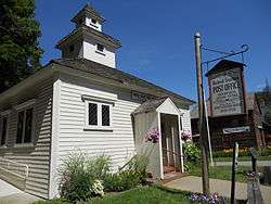 Post office in Deerfield | ||
| ||
 Location in Franklin County in Massachusetts | ||
| Coordinates: 42°32′40″N 72°36′22″W / 42.54444°N 72.60611°WCoordinates: 42°32′40″N 72°36′22″W / 42.54444°N 72.60611°W | ||
| Country | United States | |
| State | Massachusetts | |
| County | Franklin | |
| Settled | 1673 | |
| Incorporated | October 22, 1677 | |
| Government | ||
| • Type | Open town meeting | |
| Area | ||
| • Total | 33.4 sq mi (86.6 km2) | |
| • Land | 32.4 sq mi (83.9 km2) | |
| • Water | 1.1 sq mi (2.8 km2) | |
| Elevation | 150 ft (46 m) | |
| Population (2010) | ||
| • Total | 5,125 | |
| • Density | 150/sq mi (59/km2) | |
| Time zone | UTC-5 (Eastern) | |
| • Summer (DST) | UTC-4 (Eastern) | |
| ZIP code | 01342 | |
| Area code(s) | 413 | |
| FIPS code | 25-16670 | |
| GNIS feature ID | 0618162 | |
| Website |
www | |
Deerfield is a town in Franklin County, Massachusetts, United States. Settled near the Connecticut River in the 17th century during the colonial era, the population was 5,125 as of the 2010 census.[1] Deerfield is part of the Springfield, Massachusetts Metropolitan Statistical Area in western Massachusetts, lying 30 miles (48 km) north of the city of Springfield.
Deerfield includes the villages of South Deerfield and Old Deerfield, which is home to two museums; Pocumtuck Valley Memorial Association and Historic Deerfield, Inc. Historic Deerfield is designated as a National Historic Landmark district, and the organization operates a museum with a focus on decorative arts, early American material culture, and history. Its eleven house museums offer interpretation of society, history, and culture from the colonial era through the late nineteenth century. The Pocumtuck Valley Memorial Association operates Memorial Hall Museum, which opened in 1880, as well as the Indian House Memorial Children's Museum and Bloody Brook Tavern. The site of early 18th century colonial battles including the Raid on Deerfield, the town is a center of heritage tourism in the Pioneer Valley.
Deerfield has numerous schools, including Deerfield Academy, a private secondary preparatory school; Frontier Regional High School; Deerfield Elementary; and two separate private junior boarding schools, Bement School, which is co-ed; and Eaglebrook School, which admits only boys.
History
For several decades during the late seventeenth and early eighteenth centuries, Deerfield was the northwesternmost outpost of New England settlement. It occupies a fertile portion of the upper Connecticut River Valley now known as the Pioneer Valley. It was vulnerable to attack because of its position near the Berkshires highlands. For these reasons it was the site of intertribal warfare and several Anglo-French and Indian skirmishes during its early history.[2]
At the time of the English colonists' arrival, the Deerfield area was inhabited by the Algonquian-speaking Pocumtuck nation, who settled a major village by the same name. English colonists arrived in 1673, and Deerfield was incorporated in 1677. Settlement was the result of a court case in which the government in Boston returned some of Dedham to Native American control in exchange for land in the new township of Pocumtuck, on which Dedham residents could settle. The Dedham settlers' agent, John Plympton, signed a treaty with the Pocumtuck, including a man named Chaulk. But he had no authority to deed the land to the colonists and appeared to have only a rough idea of what he was signing. Native Americans and the English had different ideas about property and land use; this, along with competition for resources, contributed to conflicts between them.
The Pocumtuck were much reduced in number by the time the settlers arrived, as they had been victims of infectious diseases and war with the more powerful Mohawk. The settlers forcibly expelled the few Pocumtuck who remained; the Pocumtuck in turn sought French protection in Canada from the English colonists. At the Battle of Bloody Brook, on September 18, 1675 during King Philip's War, the dispossessed Indians destroyed a small force under the command of Captain Thomas Lathrop before being driven off by reinforcements. Colonial casualties numbered about 60. At dawn on May 19, 1676, Captain William Turner led an army of settlers in a surprise retaliatory attack on Peskeompskut, in present-day Montague, then a traditional native gathering place. Turner and his men killed 200 natives, mostly women and children. When the men of the tribe returned, they routed Turner's forces; Turner died of a mortal wound at Green River.
In the pre-dawn hours of February 29, 1704, during Queen Anne's War, joint French and Indian forces (including 47 Canadians and 200 Abenaki, along with some Kanienkehaka (Mohawk), Wyandot, and a few Pocumtuck, all under the command of Jean-Baptiste Hertel de Rouville) attacked the town in what became known as the Raid on Deerfield. They razed much of the settlement and killed 56 colonists, including 22 men, 9 women, and 25 children. The attackers took 112 captives, including women and children, and forced them on a months-long trek to Montreal, nearly 300 miles to the north. Many died along the way; others were killed because they could not keep up.
In this period, there was an active trade in ransoming captives among both the English and French. Deerfield and other communities collected funds to ransom the captives, and negotiations were conducted between the colonial governments. When the Massachusetts Bay Colony released the French pirate Pierre Maisonnat dit Baptiste, Canada arranged redemption of numerous Deerfield people, among them the prominent minister John Williams. He wrote a captivity narrative about his experience, which was published in 1707 and became well known.[3]
In addition to ransoming captives, because of losses to war and disease, families of the Mohawk and other tribes often adopted younger captives into their tribes. Such was the case with Williams's daughter Eunice, who was 8 years old when captured. She became thoroughly assimilated and at age 16 married a Mohawk man. They had a family and she stayed with the Mohawk for the rest of her life. Most of the Deerfield captives eventually returned to New England; others remained by choice in French and Native communities, such as Kahnawake, for the rest of their lives.[3]
As the frontier moved north, Deerfield became another colonial town with an unquiet early history. In 1753 Greenfield was set off and incorporated. During the early nineteenth century, Deerfield's role in Northeast agricultural production declined. It was overtaken by the rapid development of the Midwestern United States as the nation's breadbasket, as transportation to eastern markets and New York City was enhanced by construction of the Erie Canal and later railroads.

During the Colonial Revival movement of the late nineteenth century, Deerfield citizens rediscovered the town's past. Residents founded the Pocumtuck Valley Memorial Association in 1870 and erected monuments to commemorate various events, including the Bloody Brook and 1704 attacks. In 1890 Charlotte Alice Baker returned to Deerfield to restore her family home, the Frary House.[4] Baker was assisted by the Boston architectural firm Shepley, Rutan & Coolidge, and her project was one of the first in historic preservation in western Massachusetts.
Local historian George Sheldon wrote an account of the town's early history that was published in the late nineteenth century.[5] By this time South Deerfield and other New England villages were already absorbing a new wave of Eastern European immigrants, particularly from Poland. The new people influenced Deerfield's demographics and culture. They were mostly Catholic peasants, who built their own churches. Working first as laborers, they formed a community later known as Old Polonia. Twentieth-century immigrants from Poland tended to be more educated but settled in the larger cities. Immigrants in smaller communities followed different paths, and their descendants often moved to cities for more opportunities.[6]
Today, heritage tourism is Deerfield's principal industry and is important to the Pioneer Valley. "Historic Deerfield" has been designated as a National Historic Landmark district, containing eleven house museums and a regional museum and visitors' center. It focuses on decorative arts, early American material culture, and history. Its eleven house museums offer interpretation through the late nineteenth century. The Pocumtuck Valley Memorial Association operates the Memorial Hall Museum, which opened in 1880; and the Indian House Memorial Children's Museum and Bloody Brook Tavern. Deerfield is a center of heritage tourism in the Pioneer Valley near the Connecticut River. The Yankee Candle Company is an example of one of many commercial businesses associated with this history.
Geography
According to the United States Census Bureau, the town has a total area of 33.4 square miles (86.6 km2), of which 32.4 square miles (83.9 km2) is land and 1.1 square miles (2.8 km2), or 3.17 percent, is water.[7] Deerfield is located in the northern Pioneer Valley and is bordered by Greenfield to the north, Montague to the northeast, Sunderland to the southeast, Whately to the south, Conway to the west, and Shelburne to the northwest. The town center is located 8 miles (13 km) south of Greenfield, 29 miles (47 km) north of Springfield, and 93 miles (150 km) west of Boston.
Deerfield's northern point is located at the confluence of the Deerfield and Connecticut rivers, with the former flowing through the northwest corner of the town and the latter forming the eastern border of the town. Several brooks and the Mill River also flow through the town. North Sugarloaf Mountain rises above the Connecticut in the southeast corner, providing a panoramic view of the valley and the town center. The Pocumtuck Range rises along the eastern side of town north of Sugarloaf.
Interstate 91 passes from south to north through the central part of town, crossing the Deerfield River near the river's southernmost bend. The interstate is paralleled by U.S. Route 5 and Massachusetts Route 10, which run concurrently through the town. Route 116 also passes through town, combining with Routes 5 and 10 for a one-mile stretch, briefly passing into Whately before separating and crossing through the southern part of town and over the Connecticut River at the Sunderland Bridge. All three routes historically crossed through the center of the village prior to the construction of I-91 but were rerouted to a more direct route closer to the highway.
A portion of the Springfield Terminal freight rail line passes through the town before branching off eastward and westward around Greenfield. The nearest Amtrak passenger service is in Springfield; a stop in Greenfield is in operation as part of the rerouting of Amtrak's Vermonter route. Deerfield has bus service through Peter Pan Bus Lines; the nearest small air service is in Gill and Northampton. The nearest national air service is Bradley International Airport in Windsor Locks, Connecticut.
Demographics
| Historical population | ||
|---|---|---|
| Year | Pop. | ±% |
| 1840 | 1,934 | — |
| 1850 | 2,421 | +25.2% |
| 1860 | 3,073 | +26.9% |
| 1870 | 3,632 | +18.2% |
| 1880 | 3,543 | −2.5% |
| 1890 | 2,910 | −17.9% |
| 1900 | 1,969 | −32.3% |
| 1910 | 2,209 | +12.2% |
| 1920 | 2,803 | +26.9% |
| 1930 | 2,882 | +2.8% |
| 1940 | 2,684 | −6.9% |
| 1950 | 3,086 | +15.0% |
| 1960 | 3,338 | +8.2% |
| 1970 | 3,850 | +15.3% |
| 1980 | 4,517 | +17.3% |
| 1990 | 5,018 | +11.1% |
| 2000 | 4,750 | −5.3% |
| 2010 | 5,125 | +7.9% |
Source: United States Census records and Population Estimates Program data.[8][9][10][11][12][13][14][15][16][17] | ||
As of the census[18] of 2010, there were 5,125 people, 2,053 households, and 1,350 families residing in the town. The population density was 158.2 people per square mile (56.8/km²). There were 2,181 housing units. The racial makeup of the town was 95 percent White, 0.8 percent African American, 0.1 percent Native American, 1.9 percent Asian, 0.5 percent from other races, and 1.8 percent from two or more races. Hispanic or Latino of any race were 2.6 percent of the population.
There were 2,053 households, out of which 26.3 percent had their own children under the age of 18 living with them; 52.4 percent were married couples living together, 9.4 percent had a female householder with no husband present, and 34.2 percent were nonfamilies. Individuals made up 26.3 percent of all households. The average household size was 2.33, and the average family size was 2.83.
As of the American Community Survey[18] of 2015, the median income for a household was $74,853, and the median income for a family was $83,859. Men who worked full-time year-round had a median income of $70,873 versus $49,115 for similar females. The per capita income for the town was $38,379. Four percent of families and 7.5 percent of the population were below the poverty line, including 6.6 percent of those under age 18 and 7.8 percent of those age 65 or over.
Government
Deerfield employs the open town meeting form of government and is led by a board of selectmen. The town has its own police, fire, and public works departments. The fire department and the post office both have two branches, in South Deerfield (where most of the town offices are) and in Old Deerfield Village, near Memorial Hall and the Old Town Hall. The town's Tilton Library is connected to the regional library network and is located in South Deerfield. The nearest hospital, Franklin Medical Center, is located in Greenfield, as are many regional state offices.
Deerfield is represented in the Massachusetts House of Representatives by the First Franklin district, which includes the southeastern third of Franklin County and towns in north central Hampshire County. The town is represented in the Massachusetts Senate by the Hampshire and Franklin district, which includes much of eastern Franklin and Hampshire Counties.[19] The town is patrolled by the Second (Shelburne Falls) Barracks of Troop B of the Massachusetts State Police.[20]
Deerfield is represented in the United States House of Representatives as part of Massachusetts's 2nd congressional district and has been represented by Jim McGovern of Worcester. Massachusetts is currently represented in the United States Senate by senators Ed Markey and Elizabeth Warren.
Education
Deerfield is the central member of Frontier Regional and Union 38 School Districts, which also includes Conway, Whately, and Sunderland. Each town operates its own elementary school, with Deerfield Elementary School serving the town's students from kindergarten through sixth grades. All four towns send seventh through twelfth grade students to Frontier Regional School in the town. Frontier's athletics teams are nicknamed the Red Hawks, and the team colors are red and blue. There are many art programs available during and after school at Frontier. Private schools in the town include the Bement School (a coeducational boarding school for grades K–9), the Eaglebrook School (a private boys' boarding school for grades 6–9), and Deerfield Academy, a private school for grades 9–12. There are other private schools in the Deerfield area.
The nearest community college, Greenfield Community College, is located in Greenfield. The nearest state colleges are Massachusetts College of Liberal Arts in North Adams and Westfield State College; the nearest state university is the University of Massachusetts Amherst. The nearest private colleges, including members of the Five Colleges and Seven Sisters, are located to the southeast in the Northampton area.
Notable people
- Frank Boyden (1879–1972), Headmaster of Deerfield Academy
- Francis John Higginson (1843–1931), Rear Admiral in U.S. Navy, raised in Deerfield
- George Sheldon (preservationist) (1818–1916), Deerfield town historian and justice of the peace
- Jennie Maria Arms Sheldon (1852-1938), curator of Deerfield's Memorial Hall Museum
- John Williams (1817–1899), Episcopal bishop, born in Deerfield
Pictures
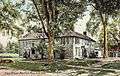 Frary House c. 1905
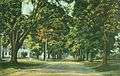 Old Main Street c. 1910
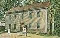 Post Office c. 1910
 Mountain Road c. 1910
References
- ↑ "Profile of General Population and Housing Characteristics: 2010 Demographic Profile Data (DP-1): Deerfield town, Franklin County, Massachusetts". U.S. Census Bureau, American Factfinder. Retrieved August 27, 2012.
- ↑ National Geographic Society (1997). Exploring America's Historic Places. National Geographic Society.
- 1 2 John Demos, The Unredeemed Captive: A Family Story from Early America, New York: Alfred A. Knopf, 1994
- ↑ Coleman, Emma Lewis (1912). A Historic and Present Day Guide to Old Deerfield, p. 54. Boston: Emma Lewis Coleman
- ↑ Sheldon, George (1896). A History of Deerfield, Massachusetts, Greenfield, Massachusetts: E. A. Hall & Co.; full text online
- ↑ Elzbieta M. Gozdziak, "Eastern Europeans", in David W. Haines, (ed.), (1996). Refugees in America in the 1990s: A Reference Handbook, pp. 124-130. Santa Barbara, CA: Greenwood Publishing Group
- ↑ "Geographic Identifiers: 2010 Demographic Profile Data (G001): Deerfield town, Franklin County, Massachusetts". U.S. Census Bureau, American Factfinder. Retrieved August 27, 2012.
- ↑ "Total Population (P1), 2010 Census Summary File 1". American FactFinder, All County Subdivisions within Massachusetts. United States Census Bureau. 2010.
- ↑ "Massachusetts by Place and County Subdivision - GCT-T1. Population Estimates". United States Census Bureau. Retrieved July 12, 2011.
- ↑ "1990 Census of Population, General Population Characteristics: Massachusetts" (PDF). US Census Bureau. December 1990. Table 76: General Characteristics of Persons, Households, and Families: 1990. 1990 CP-1-23. Retrieved July 12, 2011.
- ↑ "1980 Census of the Population, Number of Inhabitants: Massachusetts" (PDF). US Census Bureau. December 1981. Table 4. Populations of County Subdivisions: 1960 to 1980. PC80-1-A23. Retrieved July 12, 2011.
- ↑ "1950 Census of Population" (PDF). Bureau of the Census. 1952. Section 6, Pages 21-10 and 21-11, Massachusetts Table 6. Population of Counties by Minor Civil Divisions: 1930 to 1950. Retrieved July 12, 2011.
- ↑ "1920 Census of Population" (PDF). Bureau of the Census. Number of Inhabitants, by Counties and Minor Civil Divisions. Pages 21-5 through 21-7. Massachusetts Table 2. Population of Counties by Minor Civil Divisions: 1920, 1910, and 1920. Retrieved July 12, 2011.
- ↑ "1890 Census of the Population" (PDF). Department of the Interior, Census Office. Pages 179 through 182. Massachusetts Table 5. Population of States and Territories by Minor Civil Divisions: 1880 and 1890. Retrieved July 12, 2011.
- ↑ "1870 Census of the Population" (PDF). Department of the Interior, Census Office. 1872. Pages 217 through 220. Table IX. Population of Minor Civil Divisions, &c. Massachusetts. Retrieved July 12, 2011.
- ↑ "1860 Census" (PDF). Department of the Interior, Census Office. 1864. Pages 220 through 226. State of Massachusetts Table No. 3. Populations of Cities, Towns, &c. Retrieved July 12, 2011.
- ↑ "1850 Census" (PDF). Department of the Interior, Census Office. 1854. Pages 338 through 393. Populations of Cities, Towns, &c. Retrieved July 12, 2011.
- 1 2 "American FactFinder". United States Census Bureau. Retrieved 2017-04-06.
- ↑ List of Massachusetts Legislators by City and Town
- ↑ Station B-2, SP Shelburne Falls, Executive Office of Public Safety, Massachusetts State Gov.
External links
| Wikimedia Commons has media related to Deerfield, Massachusetts. |
| Wikisource has the text of the 1920 Encyclopedia Americana article Deerfield. |
Municipalities and communities of Franklin County, Massachusetts, United States | ||
|---|---|---|
| City | 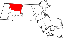 | |
| Towns | ||
| CDPs | ||
| Other villages | ||
| Ghost town | ||