Enfield Center, New Hampshire
| Enfield Center, New Hampshire | |
|---|---|
| Unincorporated community | |
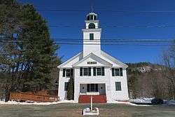 Union Church | |
 Enfield Center  Enfield Center | |
| Coordinates: 43°35′25″N 72°06′36″W / 43.59028°N 72.11000°WCoordinates: 43°35′25″N 72°06′36″W / 43.59028°N 72.11000°W | |
| Country | United States |
| State | New Hampshire |
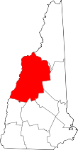
| County | Grafton |
| Town | Enfield |
| Elevation | 869 ft (265 m) |
| Time zone | UTC-5 (Eastern (EST)) |
| • Summer (DST) | UTC-4 (EDT) |
| ZIP code | 03749 |
| Area code(s) | 603 |
| GNIS feature ID | 866803[1] |
Enfield Center is an unincorporated community in the town of Enfield in Grafton County, New Hampshire. It is a separate community from the much larger village of Enfield, which is located in the northern corner of the town.
Enfield Center is located, as the name suggests, near the geographic center of the town of Enfield. It lies along New Hampshire Route 4A, about 1 mile (1.6 km) south of the south end of Mascoma Lake and about 3 miles (5 km) south of Enfield village. The Knox River flows north through the village on its way from George Pond to Mascoma Lake.
Enfield Center has a separate ZIP code (03749) from the rest of the town of Enfield.
References
This article is issued from
Wikipedia.
The text is licensed under Creative Commons - Attribution - Sharealike.
Additional terms may apply for the media files.