East Hebron, New Hampshire
| East Hebron, New Hampshire | |
|---|---|
| Unincorporated community | |
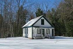 East Hebron School | |
 East Hebron  East Hebron | |
| Coordinates: 43°41′29″N 71°46′10″W / 43.69139°N 71.76944°WCoordinates: 43°41′29″N 71°46′10″W / 43.69139°N 71.76944°W | |
| Country | United States |
| State | New Hampshire |
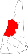
| County | Grafton |
| Town | Hebron |
| Elevation | 659 ft (201 m) |
| Time zone | UTC-5 (Eastern (EST)) |
| • Summer (DST) | UTC-4 (EDT) |
| ZIP code | 03232 |
| Area code(s) | 603 |
| GNIS feature ID | 866708[1] |
East Hebron is an unincorporated community in the town of Hebron in Grafton County, New Hampshire.
It is located along New Hampshire Route 3A on the east side of Newfound Lake. Route 3A connects Bristol to the south with Plymouth to the north.
East Hebron has a separate ZIP code (03232) from the rest of the town of Hebron.
References
This article is issued from
Wikipedia.
The text is licensed under Creative Commons - Attribution - Sharealike.
Additional terms may apply for the media files.