Ranger Bridge
| Ranger Bridge | |
|---|---|
 Ranger Bridge in 2007 | |
| Coordinates | 44°09′14″N 72°02′27″W / 44.15389°N 72.04083°WCoordinates: 44°09′14″N 72°02′27″W / 44.15389°N 72.04083°W |
| Carries |
|
| Crosses | Connecticut River |
| Locale | between Woodsville, New Hampshire and Wells River, Vermont |
| Official name | Veterans Memorial Bridge |
| Characteristics | |
| Design | steel three-hinged arch truss[1] |
| Total length | 259 feet (79 m)[1] |
| History | |
| Designer |
John W. Storrs (1917 bridge) J. R. Worcester (1923 bridge) |
| Constructed by | Boston Bridge Company (1923 bridge) |
| Construction end | 1917, 1923, 2003 rehab |
 Ranger Bridge Location in New Hampshire | |
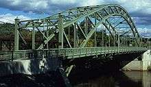
The Ranger Bridge (officially Veterans Memorial Bridge) between Wells River, Vermont and Woodsville, New Hampshire, is a three-hinged steel arch truss bridge over the Connecticut River.[1] It was built in 1923 to replace a 1917 bridge.[1] This is the oldest steel arch bridge over the Connecticut River.[1]
History
The Wells River Bridge was built in 1903 to carry rail and road traffic. In 1917, the road traffic was rerouted over a new bridge, a three-span Warren deck truss designed by John W. Storrs, just downstream, called the Ranger Bridge, for around $65,000 (US$1,240,000 with inflation[2]).[3] A flood undermined and destroyed this bridge in 1922.[1][3]
J. R. Worcester designed the next bridge, which was built by the Boston Bridge Company, the same combination of designer and builder which made the Arch Bridge in Bellows Falls 18 years earlier.[3] The current bridge was completed in 1923 as a three-hinged steel arch bridge.[1] It was rehabilitated in 2001-3. This is the oldest steel arch bridge over the Connecticut River.[1][3]
See also


- List of crossings of the Connecticut River
References
- 1 2 3 4 5 6 7 8 Knoblock, Glenn A. (25 January 2012). Historic Iron and Steel Bridges in Maine, New Hampshire and Vermont. Jefferson, North Carolina: McFarland & Company. pp. 177–178. ISBN 9780786448432.
- ↑ Federal Reserve Bank of Minneapolis Community Development Project. "Consumer Price Index (estimate) 1800–". Federal Reserve Bank of Minneapolis. Retrieved January 2, 2018.
- 1 2 3 4 List of Highway Bridges on the Connecticut River Between Vermont and New Hampshire by 1906, with Notes on Later Spans (PDF). Concord, NH: New Hampshire Division of Historical Records. July 2009. p. 8. Retrieved 29 May 2015.
External links
Crossings of the Connecticut River | ||||
|---|---|---|---|---|
| ||||