Le Soulié
| Le Soulié | ||
|---|---|---|
| Commune | ||
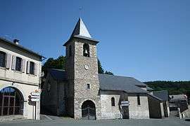 The church of Le Soulié | ||
| ||
 Le Soulié Location within Occitanie region  Le Soulié | ||
| Coordinates: 43°33′08″N 2°41′24″E / 43.5522°N 2.69°ECoordinates: 43°33′08″N 2°41′24″E / 43.5522°N 2.69°E | ||
| Country | France | |
| Region | Occitanie | |
| Department | Hérault | |
| Arrondissement | Béziers | |
| Canton | Saint-Pons-de-Thomières | |
| Intercommunality | Montagne du Haut Languedoc | |
| Government | ||
| • Mayor (2008–2014) | Guy Combes | |
| Area1 | 40.44 km2 (15.61 sq mi) | |
| Population (2008)2 | 116 | |
| • Density | 2.9/km2 (7.4/sq mi) | |
| Time zone | UTC+1 (CET) | |
| • Summer (DST) | UTC+2 (CEST) | |
| INSEE/Postal code | 34305 /34330 | |
| Elevation |
816–1,069 m (2,677–3,507 ft) (avg. 880 m or 2,890 ft) | |
|
1 French Land Register data, which excludes lakes, ponds, glaciers > 1 km2 (0.386 sq mi or 247 acres) and river estuaries. 2 Population without double counting: residents of multiple communes (e.g., students and military personnel) only counted once. | ||
.svg.png)
Le Soulié is a commune in the Hérault department in the Occitanie region in southern France.
Population
| Historical population | ||
|---|---|---|
| Year | Pop. | ±% |
| 1962 | 60 | — |
| 1968 | 120 | +100.0% |
| 1975 | 111 | −7.5% |
| 1982 | 107 | −3.6% |
| 1990 | 119 | +11.2% |
| 1999 | 121 | +1.7% |
| 2008 | 116 | −4.1% |
See also
References
| Wikimedia Commons has media related to Le Soulié. |
This article is issued from
Wikipedia.
The text is licensed under Creative Commons - Attribution - Sharealike.
Additional terms may apply for the media files.