Fourth Avenue/Ninth Street (New York City Subway)
4 Avenue/9 Street | |||||||||||||||
|---|---|---|---|---|---|---|---|---|---|---|---|---|---|---|---|
|
| |||||||||||||||
 | |||||||||||||||
| Station statistics | |||||||||||||||
| Address |
Fourth Avenue & Ninth Street Brooklyn, NY 11215 | ||||||||||||||
| Borough | Brooklyn | ||||||||||||||
| Locale | Park Slope, Gowanus | ||||||||||||||
| Coordinates | 40°40′15.44″N 73°59′29.03″W / 40.6709556°N 73.9913972°WCoordinates: 40°40′15.44″N 73°59′29.03″W / 40.6709556°N 73.9913972°W | ||||||||||||||
| Division | B (BMT/IND) | ||||||||||||||
| Line |
BMT Fourth Avenue Line IND Culver Line | ||||||||||||||
| Services |
D N R W F G | ||||||||||||||
| Transit connections |
| ||||||||||||||
| Levels | 2 | ||||||||||||||
| Station code | 608[1] | ||||||||||||||
| Traffic | |||||||||||||||
| Passengers (2017) |
4,323,467 (station complex)[2] | ||||||||||||||
| Rank | 116 out of 425 | ||||||||||||||
| |||||||||||||||
| |||||||||||||||
| |||||||||||||||


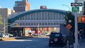
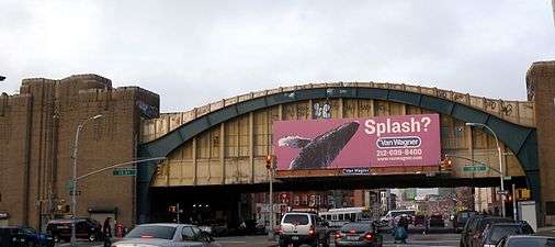
Fourth Avenue/Ninth Street is a New York City Subway station complex shared by the elevated IND Culver Line and the underground BMT Fourth Avenue Line. It is located at the intersection of Ninth Street and Fourth Avenue in Park Slope, Brooklyn and served by the:
Station layout
| 2F | Side platform, doors will open on the right | |
| Northbound local | ← ← | |
| Northbound express | No regular service | |
| Southbound express | No regular service | |
| Southbound local | | |
| Side platform, doors will open on the right | ||
| 1F | Mezzanine | Crossunder between platforms |
| Exit/Entrance, fare control, station agent, MetroCard vending machines | ||
| G | Street Level | Exit/Entrance |
| B1 | East Mezzanine | Fare control for northbound trains, MetroCard vending machines |
| Side platform, doors will open on the right | ||
| Northbound local | ← ← ← | |
| Northbound express | ← | |
| Southbound express | | |
| Southbound local | → | |
| Side platform, doors will open on the right | ||
| West Mezzanine | Fare control for southbound trains, MetroCard vending machines | |
Exits
| Exit location[3][4] | Exit type | Number of exits | Platform served |
|---|---|---|---|
| West side of 4th Avenue between 9th and 10th Streets | Staircase | 1 | Southbound Fourth Avenue Line Both Culver Line platforms |
| East side of 4th Avenue between 9th and 10th Streets | Staircase | 1 | Northbound Fourth Avenue Line Both Culver Line platforms |
| NW corner of 4th Avenue and 9th Street | Staircase | 1 | Southbound Fourth Avenue Line |
| NE corner of 4th Avenue and 9th Street | Staircase | 1 | Northbound Fourth Avenue Line |
| NW corner of 4th Avenue and 10th Street (in viaduct) | Staircase | 1 | Southbound Fourth Avenue Line Both Culver Line platforms |
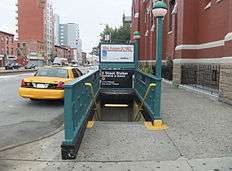
The station has five entrances. There is one entrance each in the vestibules on both sides of 4th Avenue between 9th and 10th Streets. There is also an entrance on the north side of 10th Street west of Fourth Avenue, which leads to the southbound BMT Fourth Avenue Line and both IND Culver Line platforms. The other two are entrances on either northern corner of 4th Avenue and 9th Street, and lead directly to the BMT Fourth Avenue Line platforms.[3][4]
IND Culver Line platforms
4 Avenue | |||||||
|---|---|---|---|---|---|---|---|
|
| |||||||
 Manhattan/Queens-bound platform | |||||||
| Station statistics | |||||||
| Division | B (IND) | ||||||
| Line | IND Culver Line | ||||||
| Services |
F G | ||||||
| Structure | Elevated | ||||||
| Platforms | 2 side platforms | ||||||
| Tracks | 4 (2 in regular service) | ||||||
| Other information | |||||||
| Opened | October 7, 1933 | ||||||
| Station code | 239[1] | ||||||
| Station succession | |||||||
| Next north |
Smith–Ninth Streets: F | ||||||
| Next south |
Seventh Avenue: F | ||||||
| |||||||
|
| |||||||
|
4th Avenue Station (IND) | |||||||
| MPS | New York City Subway System MPS | ||||||
| NRHP reference # | 05000673[5] | ||||||
| Added to NRHP | July 6, 2005 | ||||||
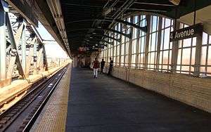
Fourth Avenue, opened on October 7, 1933, is a local station on the IND Culver Line that has four tracks and two side platforms. The center express tracks are not used in regular service. The platforms are the IND's usual length of 660 feet, and the width of the platforms is 16 feet.[6] Both platforms have tan brick windscreens and column-less cantilevered windscreens along their entire lengths except for a small portion of the west (railroad north) end. The station has a crew quarters structure over both platforms which is constructed of brick with evidence of covered windows.
This station's fare control area is at street level underneath the platforms and tracks and built within the viaduct's concrete structure. Two staircases from each platform near their east end go down to a balcony (where mosaics reading "MEN" and "WOMEN" for two now-closed restrooms are visible) before three staircases go down to the turnstile bank. Outside fare control, there is a token booth and two sets of entry/exit doors, one to the west side of Fourth Avenue directly underneath the viaduct and the other to the north side of Tenth Street. Both entrances have their original lit-up IND "SUBWAY" sign while mosaic direction tiles reading "To Coney Island" and "To Manhattan" are in the mezzanine.
The fare control area has a single staircase going down to the extreme south end of the Bay Ridge-bound platform of Ninth Street on the BMT Fourth Avenue Line. The extreme east (railroad south) ends of each platform have a single staircase going down to a now-abandoned entry/exit that led to the east side of Fourth Avenue underneath the viaduct at ground level. Another staircase from this eastern landing goes down to the Manhattan-bound platform of Ninth Street. The staircase and mezzanine areas have tile accents of green.
West of this station was a short stub-end reversing spur entered only from this station. It remained level between the two express tracks while the other tracks ramped up toward Smith–Ninth Streets. The track was removed during overhaul of the Culver Viaduct from 2007 to 2013 (see § Renovation).[7] East of this station, the line enters a tunnel toward Seventh Avenue. That station is underground, but at a higher altitude than this elevated station due to the steep slope of the land (hence the neighborhood name of Park Slope).
Renovation
In 2007, the MTA announced a three-year renovation project of the elevated Culver Viaduct.[8] The work area covers from south of Carroll Street to north of Ditmas Avenue. Reconstruction the Fourth Avenue and Smith-9th Streets stations was completed in April 2013. Along with the viaduct project, the MTA re-opened the east station house to the station, after it had been closed for over 40 years.[9]
Before 2009, G service terminated at Smith–Ninth Streets, one stop to the north.[10] Terminating southbound trains used the switches just west of Fourth Avenue to enter the southbound express tracks. After being stored on the southbound express track, the G trains would start their Queens-bound runs by using the switches to enter the northbound local track.[11] The switches were taken out of regular service in 2009, when the viaduct's reconstruction started and the G was extended permanently to Church Avenue.[12][10]
Gallery
 IND Culver Line station in 2010, before the beginning of construction
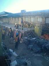 Demolition of the old platform during construction
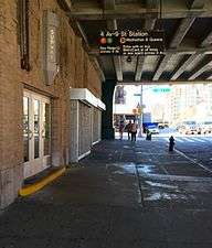 One of two entrances under the bridge to the IND Culver Line platforms
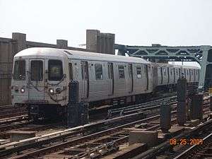 R46 G train switching tracks at Fourth Avenue when G service terminated at Smith–Ninth Streets prior to July 2009
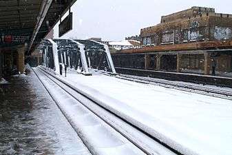 The station in winter
BMT Fourth Avenue Line platforms
9 Street | |||||||||||||
|---|---|---|---|---|---|---|---|---|---|---|---|---|---|
|
| |||||||||||||
 Platform towards Manhattan | |||||||||||||
| Station statistics | |||||||||||||
| Division | B (BMT) | ||||||||||||
| Line | BMT Fourth Avenue Line | ||||||||||||
| Services |
D N R W | ||||||||||||
| Structure | Underground | ||||||||||||
| Platforms | 2 side platforms | ||||||||||||
| Tracks | 4 | ||||||||||||
| Other information | |||||||||||||
| Opened | June 22, 1915[13] | ||||||||||||
| Station code | 029[1] | ||||||||||||
| Wireless service |
| ||||||||||||
| Station succession | |||||||||||||
| Next north |
Union Street: D | ||||||||||||
| Next south |
Prospect Avenue: D | ||||||||||||
| |||||||||||||
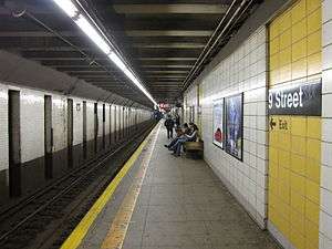
Ninth Street on the BMT Fourth Avenue Line, which opened on June 22, 1915,[13] is a local station that has four tracks and two side platforms.
Both platforms have cinder-block tiles installed during a 1970s renovation that replaced the original mosaic trim line and name tablets. They are colored white except for the areas that have the stations signs. In this case, they are colored yellow. Beige columns run along both platforms at either ends where they were extended in the 1960s to accommodate lengthened trains.
Each platform has one same-level fare control area in the middle. The one on the Manhattan-bound platform has a turnstile bank, token booth, and one staircase going up to the northeast corner of Ninth Street and Fourth Avenue. This fare control area still has the station's original trim line with "9" tablets at regular intervals. The fare control area on the Bay Ridge-bound platform is unstaffed, containing one High Entry/Exit Turnstile, one exit-only turnstile, a row of four low turnstiles, and a staircase to the northwest corner of Ninth Street and Fourth Avenue.
At the extreme south end of both platforms, staircases lead up to exit/entrance areas at street level. The fare control area on the Bay Ridge-bound (western) side of the station is still operating, but the exit/entrance area on the Manhattan-bound (eastern) side of the station is closed. On each side, staircases go up to either of the IND platforms at Fourth Avenue.
References
- 1 2 3 "Station Developers' Information". Metropolitan Transportation Authority. Retrieved June 13, 2017.
- ↑ "Facts and Figures: Annual Subway Ridership 2012–2017". Metropolitan Transportation Authority. July 12, 2018. Retrieved July 12, 2018.
- 1 2 "MTA Neighborhood Maps: Red Hook" (PDF). mta.info. Metropolitan Transportation Authority. 2015. Retrieved August 2, 2015.
- 1 2 "MTA Neighborhood Maps: Park Slope" (PDF). mta.info. Metropolitan Transportation Authority. 2015. Retrieved August 2, 2015.
- ↑ "NPS Focus". National Register of Historic Places. National Park Service. Retrieved December 24, 2011.
- ↑ Kramer, Frederick A. (January 1, 1990). Building the Independent Subway. Quadrant Press. ISBN 9780915276509.
- ↑ http://ltvsquad.com/2011/02/21/highest-lowpoint/
- ↑ McLaughlin, Mike (November 24, 2007). "Fix for Fourth Avenue station looks F'ing great". The Brooklyn Paper. Retrieved November 27, 2007.
- ↑ "4th Avenue East Side Station House Reopens". MTA.info. February 23, 2012. Retrieved February 24, 2012.
- 1 2 "Review of the G Line" (PDF). mta.info. Metropolitan Transportation Authority. July 10, 2013. Retrieved August 2, 2015.
- ↑ "Review of the G Line: Appendices" (PDF). Metropolitan Transportation Authority. July 10, 2013. Retrieved 28 October 2015.
- ↑ "MTA NYC Transit - Service Advisory". mta.info. Metropolitan Transportation Authority. July 2009. Archived from the original on July 9, 2009. Retrieved October 30, 2016.
- 1 2 "Through Tube to Coney, 48 Minutes: First Train on Fourth Avenue Route Beats West End Line Eleven Minutes". Brooklyn Daily Eagle. June 22, 1915. Retrieved June 29, 2015 – via Newspapers.com.
- ↑ "NYC Subway Wireless – Active Stations". Transit Wireless Wifi. Retrieved May 18, 2016.
External links
| Wikimedia Commons has media related to 4th Avenue / 9th Street (New York City Subway). |
- nycsubway.org – IND Crosstown: 4th Avenue
- nycsubway.org – BMT 4th Avenue: 9th Street
- Station Reporter — 4th Avenue/Ninth Street Complex
- The Subway Nut — 9th Street (M,R) Pictures
- The Subway Nut — 4th Avenue (F,G) Pictures
- Ninth Street entrance from Google Maps Street View
- Fourth Avenue west entrance under viaduct from Google Maps Street View
- Fourth Avenue east entrance under viaduct from Google Maps Street View
- Other entrance on 10th Street from Google Maps Street View
- IND platforms from Google Maps Street View
- BMT platform from Google Maps Street View
| Topics |   | |
|---|---|---|
| Lists by county |
| |
| Lists by city | ||
| Other lists | ||
| ||