Nassau Avenue (IND Crosstown Line)
Nassau Avenue | |||||||
|---|---|---|---|---|---|---|---|
|
| |||||||
 Southbound platform | |||||||
| Station statistics | |||||||
| Address |
Nassau Avenue & Manhattan Avenue Brooklyn, NY 11222 | ||||||
| Borough | Brooklyn | ||||||
| Locale | Greenpoint | ||||||
| Coordinates | 40°43′26″N 73°57′03″W / 40.723811°N 73.95082°WCoordinates: 40°43′26″N 73°57′03″W / 40.723811°N 73.95082°W | ||||||
| Division | B (IND) | ||||||
| Line | IND Crosstown Line | ||||||
| Services |
G | ||||||
| Transit connections |
| ||||||
| Structure | Underground | ||||||
| Platforms | 2 side platforms | ||||||
| Tracks | 2 | ||||||
| Other information | |||||||
| Opened | August 19, 1933[1] | ||||||
| Station code | 284[2] | ||||||
| Wireless service |
| ||||||
| Traffic | |||||||
| Passengers (2017) |
2,765,172[4] | ||||||
| Rank | 188 out of 425 | ||||||
| Station succession | |||||||
| Next north |
Greenpoint Avenue: G | ||||||
| Next south |
Metropolitan Avenue: G | ||||||
| |||||||
| |||||||
| |||||||


Nassau Avenue is a station on the IND Crosstown Line of the New York City Subway. Located at the intersection of Manhattan and Nassau Avenues in Greenpoint, Brooklyn, it is served by the G train at all times.
Station layout
| G | Street level | Entrances/exits |
| M | Mezzanine | To entrances/exits, station agent, MetroCard machines |
| P Platform level |
Side platform, doors will open on the right | |
| Northbound | ← | |
| Southbound | | |
| Side platform, doors will open on the right | ||
Opened on August 19, 1933, Nassau Avenue was the terminal station of the IND Crosstown Line during the first phase of the opening of the line.[1] This station served as the terminal of the Crosstown Line until the remainder of the line opened on July 1, 1937.[5][6]
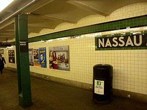
This underground station, has two tracks and two side platforms.[7][8] Both platforms have a green trim line on a black border and name tablets reading "NASSAU AVE." in white arial font on a black background and green border. Small "NASSAU" tiles in white lettering on a black background are directly below the trim line and directional signs in the same style are below the name tablets. Green columns run along both platforms at regular intervals with alternating ones having the standard black name plate in white lettering.[1]
North of the station is a diamond crossover switch, allowing terminating trains to reverse direction.[7][9][8] This switch was used in regular service until July 1, 1937, when the remainder of the Crosstown line opened.[5][6] Prior to that, Nassau Avenue was the line's southern terminus.[1][10][11] South of the station, the line shifts from Manhattan Avenue onto Union Avenue, running diagonally under McCarren Park.[12]
Exits
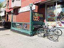
The station's full-time fare control is at the south end, which is the more heavily used of the station's two entry-exit points. A short staircase from each platform goes up to mezzanine level. On the Church Avenue-bound side, one exit-only turnstile and one High Entry/Exit Turnstile leads to two staircases going up to either western corners of Manhattan and Nassau Avenues. The Queens-bound side has the station's full-time turnstile bank, token booth, and two staircases going up to either eastern corners of the same intersection. A raised crossover connects the two sides both inside and outside fare control and is split in two by a steel fence. The mezzanine has mosaic directional signs in white lettering on a green background.[7][12] G trains, which are about half the length of the 600-foot (180 m) platform, stop near the south end of the station.[7][9]
Both platforms have an unstaffed platform-level fare control at their north end, with no crossover. On the Church Avenue-bound side, one exit-only turnstile and one High Entry/Exit Turnstile lead to a single staircase going up to the northwest corner of Norman and Manhattan Avenues. On the Queens-bound side, a single full height turnstile leads to a staircase going up to the northeast corner of the same intersection.[7][12]
In preparation for the 14th Street Tunnel shutdown in 2019, the split free/paid area at the south end of the station would be reconfigured into an exclusively unpaid area. This would remove the free transfer between platforms, but would allow for increased flow from passengers entering and exiting the station.[13]
References
- 1 2 3 4 "TWO SUBWAY UNITS OPEN AT MIDNIGHT; Links in City-Owned System in Queens and Brooklyn to Have 15 Stations" (PDF). The New York Times. August 18, 1933. Retrieved November 7, 2015.
- ↑ "Station Developers' Information". Metropolitan Transportation Authority. Retrieved June 13, 2017.
- ↑ "NYC Subway Wireless – Active Stations". Transit Wireless Wifi. Retrieved May 18, 2016.
- ↑ "Facts and Figures: Annual Subway Ridership 2012–2017". Metropolitan Transportation Authority. July 12, 2018. Retrieved July 12, 2018.
- 1 2 "New Crosstown Subway Line Is Opened". Brooklyn Daily Eagle. July 1, 1937. Retrieved December 24, 2015.
- 1 2 Kramer, Frederick A. (January 1, 1990). Building the Independent Subway. Quadrant Press. ISBN 9780915276509.
- 1 2 3 4 5 "Review of the G Line: Appendices" (PDF). Metropolitan Transportation Authority. July 10, 2013. Retrieved October 28, 2015.
- 1 2 Dougherty, Peter (2006) [2002]. Tracks of the New York City Subway 2006 (3rd ed.). Dougherty. OCLC 49777633 – via Google Books.
- 1 2 "Review of the G Line" (PDF). mta.info. Metropolitan Transportation Authority. July 10, 2013. Retrieved August 2, 2015.
- ↑ "Independent Subway Services Beginning in 1932". thejoekorner.com. August 21, 2013. Retrieved August 2, 2015.
- ↑ O'Neill, Natalie (July 19, 2012). "G wiz! MTA plans to save the G train extension!". The Brooklyn Paper. Retrieved July 21, 2012.
- 1 2 3 "MTA Neighborhood Maps: Greenpoint" (PDF). Metropolitan Transportation Authority. 2015. Retrieved November 7, 2015.
- ↑ New York City Transit Authority (July 2018). "MTA New York City Transit Canarsie Tunnel Project Supplemental Environmental Assessment and Section 4(f) Review: Final Report" (PDF). mta.info. Metropolitan Transportation Authority. p. 15. Retrieved 2018-07-27.
External links
| Wikimedia Commons has media related to Nassau Avenue (IND Crosstown Line). |
- nycsubway.org – IND Crosstown Line: Nassau Avenue
- Station Reporter — G Train
- The Subway Nut — Nassau Avenue Pictures
- Nassau Avenue entrance from Google Maps Street View
- Norman Avenue entrance from Google Maps Street View
- Platforms from Google Maps Street View
Crosstown |
|
|---|---|
| |
| Crosstown Line |
|
|---|---|
| |