Roosevelt Island (IND 63rd Street Line)
Roosevelt Island | |||||||
|---|---|---|---|---|---|---|---|
|
| |||||||
 | |||||||
| Station statistics | |||||||
| Address |
Main Street near Road 5 New York, NY 10044 | ||||||
| Borough | Manhattan | ||||||
| Locale | Roosevelt Island | ||||||
| Coordinates | 40°45′33″N 73°57′12″W / 40.759188°N 73.953438°WCoordinates: 40°45′33″N 73°57′12″W / 40.759188°N 73.953438°W | ||||||
| Division | B (IND) | ||||||
| Line | IND 63rd Street Line | ||||||
| Services |
F | ||||||
| Transit connections |
⛴ NYC Ferry: Astoria route | ||||||
| Structure | Underground | ||||||
| Depth | 100 feet (30.5 m) | ||||||
| Platforms | 2 side platforms | ||||||
| Tracks | 2 | ||||||
| Other information | |||||||
| Opened | October 29, 1989[1] | ||||||
| Station code | 222[2] | ||||||
| Accessible |
| ||||||
| Wireless service |
| ||||||
| Traffic | |||||||
| Passengers (2017) |
2,361,627[4] | ||||||
| Rank | 209 out of 425 | ||||||
| Station succession | |||||||
|
| |||||||
| Next |
21st Street–Queensbridge: F | ||||||
| Next |
Lexington Avenue–63rd Street: F | ||||||
| |||||||
| |||||||
| |||||||


Roosevelt Island is a station on the IND 63rd Street Line of the New York City Subway. Located in Manhattan on Roosevelt Island in the East River, it is served by the F train at all times.
At 100 feet (30 m) below ground, the station is one of the deepest in the system. The depth of the station is required because the line has to pass under the West and East Channels of the East River. Additionally, this station is one of two subway stations in Manhattan that are not located on Manhattan Island itself (the other one being Marble Hill–225th Street).[5]
In the 1960s, the New York City Transit Authority (NYCTA) announced that it would build a subway station on Roosevelt Island to encourage transit-oriented development on the island. When construction of the line was delayed, the Roosevelt Island Tram was built in 1973. The Roosevelt Island Operating Corporation was formed in 1984 to develop the island, but was not successful until October 1989 when the subway station opened along with the rest of the 63rd Street Line. The opening encouraged the development of the island, which has made the station busier.
Until December 2001, this was the second-to-last stop of the line, which terminated one stop east at 21st Street–Queensbridge. In 2001 the 63rd Street Tunnel Connection opened, allowing trains from the IND Queens Boulevard Line to use the line. Since the opening of the connection, the line has been served by F trains, and the subway then became the second means for direct travel between the island and Queens, supplementing the buses that had been operating over the Roosevelt Island Bridge.
History
Background
Roosevelt Island was once home to a penitentiary and some asylums, as well as being home to numerous hospitals. It was originally called Blackwell's Island, but in 1921 it became known as Welfare Island because of the numerous hospitals on the island. The island became neglected once the hospitals started closing and their buildings were left abandoned to decay. During the 1960s, some groups started proposing uses for the island.[6]
On February 16, 1965, the New York City Transit Authority announced plans to construct a subway station on the island along the planned 63rd Street Line, as part of the island's proposed transit-oriented development (TOD). TOD tries to increase the amount of residential, business and leisure space within walking distance of public transport. With this announcements, more suggestions for what to do with the island were made.[6] The construction of a station was viewed to be vital for the development of the island, which was still known as Welfare Island. At that point, it was decided to build a shell for the station, to allow for the station to open after the opening of the rest of the line, with a projected savings of $4 million compared to building the station as an infill station after the rest of the line opened. The projected cost of the station was $3,300,000.[7] It was soon decided to build the station with the rest of the line.[8]
The 63rd Street Line was the final version of proposals for a northern midtown tunnel from the IND Queens Boulevard Line to the Second and Sixth Avenue lines, which dated back to the IND Second System of the 1920s and 1930s.[9]:246[10]:417[11][12] The current plans were drawn up in the 1960s under the Metropolitan Transportation Authority's Program For Action.[13]:5, 21
Beginning in the mid-1970s, Roosevelt Island was redeveloped to accommodate low- to mid-income housing projects. However, there was no direct transit connection to Manhattan. The subway was delayed and still under construction; trolley tracks that formerly served Roosevelt Island via the Queensboro Bridge were unusable; and the only way on and off the island was via the Roosevelt Island Bridge to Queens. A tram route, the Roosevelt Island Tramway, was opened in May 1976 as a "temporary" connection to Manhattan.[14] The Roosevelt Island Operating Corporation was formed in 1984 to develop the island, but was not successful until October 1989 when the subway station opened along with the rest of the 63rd Street Line. After that, a high-rise luxury apartment building with some subsidized housing opened.[6]
Opening
This station opened on October 29, 1989[15] along with the entire IND 63rd Street Line.[1][16] The opening of the subway resulted in a steep decline in Roosevelt Island Tramway ridership.[17]
The Q train served the station on weekdays and the B train stopped there on the weekends; both services used the Sixth Avenue Line.[1] For the first couple of months after the station opened, the JFK Express to Kennedy Airport also served the station until it was discontinued in 1990.[18]
The 63rd Street Tunnel had gained notoriety as the "tunnel to nowhere" both during its planning and after its opening, as the line's northern terminus at 21st Street–Queensbridge, one stop after Roosevelt Island, was not connected to any other subway station or line in Queens.[12][1] This changed in 2001 when the connection to the Queens Boulevard Line was completed and opened. Thereafter, the station began being served by the F train, which serves Roosevelt Island to this day.[19]:5[20] :2[21]
At an April 14, 2008, news conference, Governor David Paterson announced that the MTA will power a substantial portion of the station using tidal energy generated by turbines located in the East River, which are part of the Roosevelt Island Tidal Energy Project.[22] This is part of a larger MTA initiative to use sustainable energy resources within the subway system.[23]
Station layout
| G | Street Level | Exit/Entrance |
| Fare control, station agent, MetroCard vending machines | ||
| B1 | Upper Mezzanine | Escalator landing |
| B2 | Lower Mezzanine | Transfer between platforms |
| B3 Platform level |
Side platform, doors will open on the right | |
| Southbound | ← | |
| Northbound | → | |
| Side platform, doors will open on the right | ||
| B4 | Track 1 | ← LIRR East Side Access (under construction) |
| Track 2 | LIRR East Side Access (under construction) → | |
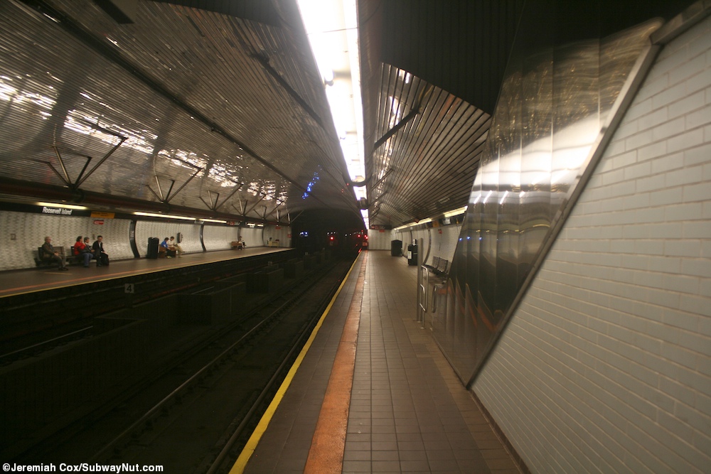
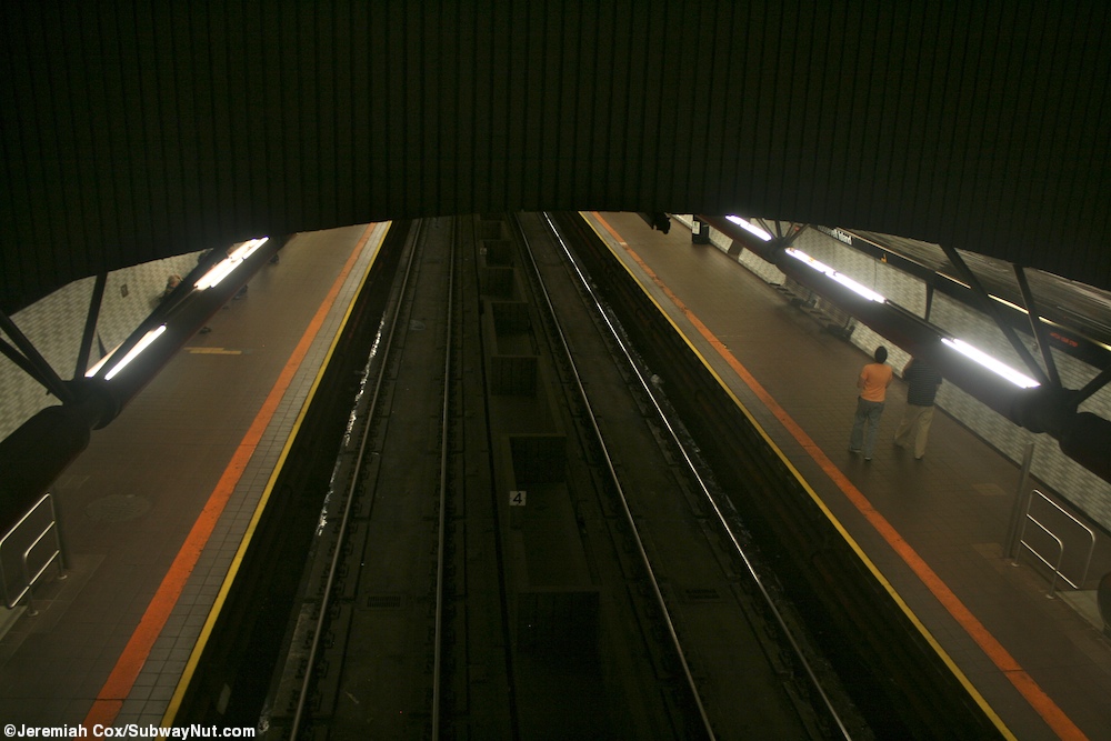
The station has two tracks and two side platforms. It is the fourth-deepest station in the New York City Subway at about 100 feet (30 m) below street level (approximately 10 stories deep) behind 34th Street–Hudson Yards, 190th Street, and 191st Street stations, also in Manhattan.[24] Due to its depth, the station contains several features not common in the rest of the system. Similar to stations of the Paris Metro and Washington Metro, the Roosevelt Island station was built with a high vaulted ceiling and a mezzanine directly visible above the tracks.[25][26][27][lower-alpha 1]
The station is fully ADA-accessible, with elevators to street level.[28] West of this station, there is a diamond crossover[29]:21 and two bellmouths that curve southward toward an unbuilt portion of the Second Avenue Subway.[30] The station has an unused lower level,[31][32] which will be used by Long Island Rail Road trains once East Side Access is completed.[32][33]
Exit
Fare control is in a glass-enclosed headhouse building off of Main Street.[34] The headhouse has a feature that is unusual to the subway system: it uses recordings of birds to try to scare away city pigeons, and these bird recordings play every few minutes or so. The system was installed because of issues with pigeons entering the headhouse and leaving feathers and droppings both inside and around the building. Previous efforts, like spiked ledges, had been ineffective in curbing the pigeon population of the area immediately next to the station.[35]
Ridership
When the station opened in 1989, daily ridership on the Roosevelt Island Tramway, an aerial tramway that also connects Roosevelt Island to Manhattan, decreased sharply, from 5,500 daily riders in 1989 to 3,000 by 1993.[36] In 2008, the subway station saw about 5,900 daily riders, compared to 3,000 for the tram, which had maintained steady ridership.[37] Over the next eight years, the station experienced additional ridership growth. In 2016, an average of 6,630 daily riders used the station on an average weekday.[38] This amounted to 2,110,471 total riders entering the station in 2016.[4]
Nearby points of interest
The station serves several destinations on Roosevelt Island. On the northern part of the island is the Bird S. Coler Hospital, a large city-owned facility.[34][39] On the southern portion of the island, Cornell University and Technion – Israel Institute of Technology opened their new 2,000,000-square-foot (190,000 m2) Cornell Tech campus,[34] which will focus on new applied science and technology, in September 2017.[40][41] On Main Street is the Good Shepherd Church,[34] which was built in 1888 and is on the National Register of Historic Places.[42] A ballfield on the island is named Firefighters Field[34] in honor of three firefighters that died while trying to save lives in the September 11 attacks.[43] The Roosevelt Island Tramway, which was intended to be replaced by the subway, is still in service with a terminal just south of the subway entrance.[34] It is used by commuters and tourists alike.[44]
Gallery
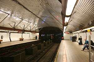
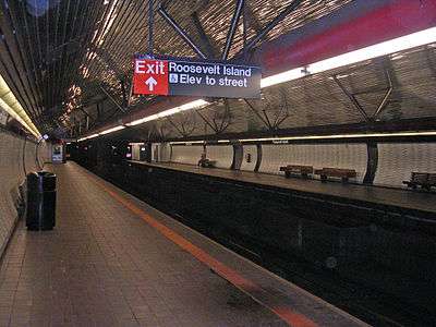 A view of the platform and tracks at the station.
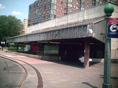 A view of the station's only exit, which is located on Main Street.
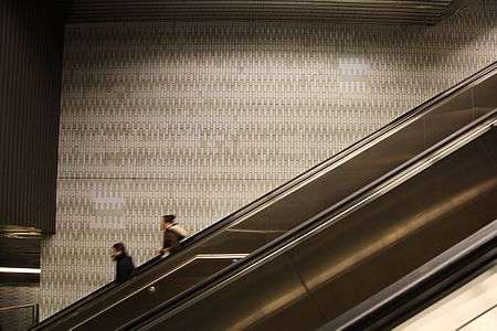 This long escalator between the mezzanine and the headhouse is necessary as the station is deep enough to pass under the East River.
Notes
- ↑ These features can also be found on some of the system's other deep stations, including Grand Central, 168th Street, and 181st Street stations, along with future stations along the Second Avenue Subway.
References
- 1 2 3 4 Lorch, Donatella (October 29, 1989). "The 'Subway to Nowhere' Now Goes Somewhere". The New York Times. Retrieved September 26, 2009.
- ↑ "Station Developers' Information". Metropolitan Transportation Authority. Retrieved June 13, 2017.
- ↑ "NYC Subway Wireless – Active Stations". Transit Wireless Wifi. Retrieved May 18, 2016.
- 1 2 "Facts and Figures: Annual Subway Ridership 2012–2017". Metropolitan Transportation Authority. July 12, 2018. Retrieved July 12, 2018.
- ↑ "Subway Map" (PDF). Metropolitan Transportation Authority. January 18, 2018. Retrieved January 18, 2018.
- 1 2 3 Seitz, Sharon; Miller, Stuart (June 6, 2011). The Other Islands of New York City: A History and Guide (Third Edition). The Countryman Press. pp. 161–163. ISBN 9781581578867.
- ↑ "Welfare Island To Be On Subway; Station to Be Built in New 63d St. Tunnel to Queens" (PDF). The New York Times. February 17, 1965. Retrieved October 10, 2016.
- ↑ Kihss, Peter (April 7, 1967). "State Gives Fund For 63rd St. Tunnel; $37.5-Million Allocated for Subway Tube to Queens --New Line Studied". The New York Times. ISSN 0362-4331. Retrieved June 12, 2017.
- ↑ Raskin, Joseph B. (November 1, 2013), The Routes Not Taken: A Trip Through New York City's Unbuilt Subway System, Fordham University Press, ISBN 978-0-8232-5369-2
- ↑ Roger P. Roess; Gene Sansone (August 23, 2012). The Wheels That Drove New York: A History of the New York City Transit System. Springer Science & Business Media. pp. 416–417. ISBN 978-3-642-30484-2.
- ↑ Project for Expanded Rapid Transit Facilities, New York City Transit System, dated July 5, 1939
- 1 2 Knowles, Clayton (December 16, 1964). "Proposed Subway Tube Assailed As 'Nowhere‐to‐Nowhere' Link". The New York Times. Retrieved September 27, 2015.
- ↑ Dougherty, Peter (2018). Tracks of the New York City Subway 2018 (16th ed.). Dougherty.
- ↑ Ferretti, Fred (May 18, 1976). "Aerial Tram Ride to Roosevelt Island Is Opened With a Splash on O'Dwyer" (PDF). The New York Times. Retrieved June 12, 2017.
- ↑ "63 St Subway Extension Opened 25 Years Ago this Week". www.mta.info. Metropolitan Transportation Authority. October 31, 2014. Retrieved June 12, 2017.
- ↑ Kershaw, Sarah (December 17, 2001). "V Train Begins Service Today, Giving Queens Commuters Another Option". The New York Times. Retrieved October 16, 2011.
- ↑ Howe, Marvine (December 26, 1993). "NEIGHBORHOOD REPORT: ROOSEVELT ISLAND; When Will Troubled Tram Reopen? Give It a Few More Weeks". The New York Times. ISSN 0362-4331. Retrieved July 26, 2016.
- ↑ Grynbaum, Michael M. (November 25, 2009). "If You Took the Train to the Plane, Sing the Jingle". Retrieved July 3, 2016.
- ↑ "Review of F Line Operations, Ridership, and Infrastructure" (PDF). nysenate.gov. MTA New York City Transit Authority. October 7, 2009. Archived from the original (PDF) on May 31, 2010. Retrieved July 28, 2015.
- ↑ "Review of the G Line" (PDF). mta.info. Metropolitan Transportation Authority. July 10, 2013. Retrieved August 2, 2015.
- ↑ Kennedy, Randy (May 25, 2001). "Panel Approves New V Train but Shortens G Line to Make Room". The New York Times. Retrieved March 20, 2010.
- ↑ "ROOSEVELT ISLAND TIDAL ENERGY PROJECT FERC No. 12611" (PDF). verdantpower.com. December 2010. p. A-15. Retrieved June 12, 2017.
- ↑ Ehrlich, David (April 15, 2008). "New York transit going green". Clean Tech Group, LLC. Archived from the original on April 20, 2008.
- ↑ "The Deepest and Highest Subway Stations in NYC: 191st St, 190th Street, Smith & 9th". Untapped Cities. June 26, 2013. Retrieved June 12, 2017.
- ↑ Cox, Jeremiah (May 24, 2010). "Looking down the station platforms alongside an escalator". subwaynut.com. Retrieved June 12, 2017.
- ↑ Cox, Jeremiah (May 24, 2010). "Looking down off the mezzanine to the tracks". subwaynut.com. Retrieved June 12, 2017.
- ↑ Vega-Barachowitz, David (February 15, 2008). "Hanging Out with the Gangs of New York on Roosevelt Island". Columbia Daily Spectator. Retrieved December 21, 2016.
- ↑ "Accessible Stations in the MTA Network". web.mta.info. Metropolitan Transportation Authority. Retrieved November 29, 2016.
- ↑ Dougherty, Peter (2018). Tracks of the New York City Subway 2018 (16th ed.). Dougherty.
- ↑ Brennan, Joseph (2002). "Abandoned Stations: Lexington Ave (63 St) north side". Retrieved October 20, 2011.
- ↑ Final Environmental Impact Statement for the 63rd Street Line Connection to the Queens Boulevard Line. Queens, New York, New York: Metropolitan Transportation Authority, United States Department of Transportation, Federal Transit Administration. June 1992. Retrieved July 23, 2016.
- 1 2 East Side Access in New York, Queens, and Bronx Counties, New York, and Nassau and Suffolk Counties, New York: Environmental Impact Statement. Metropolitan Transportation Authority, United States Department of Transportation, Federal Transit Administration. March 2001. Retrieved July 23, 2016.
- ↑ "Project Overview". MTA.info. Retrieved April 21, 2014.
- 1 2 3 4 5 6 "MTA Neighborhood Maps: Long Island City" (PDF). mta.info. Metropolitan Transportation Authority. 2015. Retrieved September 27, 2015.
- ↑ Haughney, Christine (March 18, 2012). "M.T.A. Uses Bird Recordings to Scare Pigeons From Roosevelt Island Station". The New York Times. ISSN 0362-4331. Retrieved July 26, 2016.
- ↑ Howe, Marvine (December 26, 1993). "NEIGHBORHOOD REPORT: ROOSEVELT ISLAND; When Will Troubled Tram Reopen? Give It a Few More Weeks". The New York Times. ISSN 0362-4331. Retrieved July 26, 2016.
- ↑ Hernandez, Javier C. (June 14, 2008). "What Is Life Without a Tram? Residents Are Getting a Taste". The New York Times. ISSN 0362-4331. Retrieved July 26, 2016.
- ↑ "Facts and Figures: Average Weekday Subway Ridership 2012–2017". Metropolitan Transportation Authority. July 12, 2018. Retrieved July 12, 2018.
- ↑ "Hospital Patients Forced Out as Roosevelt Island Tech Campus Moves In - Roosevelt Island". DNAinfo.com. Archived from the original on July 4, 2015. Retrieved July 19, 2015.
- ↑ Harris, Elizabeth A. (September 13, 2017). "High Tech and High Design, Cornell's Roosevelt Island Campus Opens". The New York Times. ISSN 0362-4331. Retrieved September 13, 2017.
- ↑ Lange, Alexandra (September 13, 2017). "Cornell Tech's new NYC campus puts sustainable architecture into practice". Curbed NY. Retrieved September 13, 2017.
- ↑ National Park Service (2007-01-23). "National Register Information System". National Register of Historic Places. National Park Service.
- ↑ "Louis Pasteur Park Highlights - Firefighter Field : NYC Parks". www.nycgovparks.org. Retrieved July 28, 2016.
- ↑ Brown, Nicole (May 16, 2016). "What to know about the Roosevelt Island Tram". am New York. Retrieved June 12, 2017.
External links
| Wikimedia Commons has media related to Roosevelt Island (IND 63rd Street Line). |
- nycsubway.org – IND 6th Avenue: Roosevelt Island
- F Train at Station Reporter
- Station house and entrance from Google Maps Street View
- Platforms from Google Maps Street View
- Mezzanine from Google Maps Street View
- Lobby from Google Maps Street View
| 63rd St. Lines |
|
|---|---|
| |