Bedford–Nostrand Avenues (IND Crosstown Line)
Bedford–Nostrand Avenues | |||||||
|---|---|---|---|---|---|---|---|
|
| |||||||
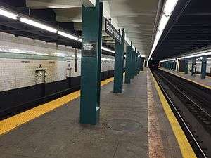 Queens bound platform | |||||||
| Station statistics | |||||||
| Address |
Lafayette Avenue between Nostrand Avenue & Bedford Avenue Brooklyn, NY 11216 | ||||||
| Borough | Brooklyn | ||||||
| Locale | Bedford-Stuyvesant | ||||||
| Coordinates | 40°41′23″N 73°57′13″W / 40.689587°N 73.953567°WCoordinates: 40°41′23″N 73°57′13″W / 40.689587°N 73.953567°W | ||||||
| Division | B (IND) | ||||||
| Line | IND Crosstown Line | ||||||
| Services |
G | ||||||
| Transit connections |
| ||||||
| Structure | Underground | ||||||
| Platforms |
2 island platforms cross-platform interchange | ||||||
| Tracks | 3 (2 in regular service) | ||||||
| Other information | |||||||
| Opened | July 1, 1937[1] | ||||||
| Station code | 289[2] | ||||||
| Wireless service |
| ||||||
| Traffic | |||||||
| Passengers (2017) |
2,779,124[4] | ||||||
| Rank | 186 out of 425 | ||||||
| Station succession | |||||||
| Next north |
Myrtle–Willoughby Avenues: G | ||||||
| Next south |
Classon Avenue: G | ||||||
| |||||||
| |||||||
| |||||||


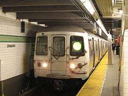
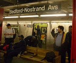
Bedford–Nostrand Avenues is a station on the IND Crosstown Line of the New York City Subway. Located at Lafayette Avenue between Bedford and Nostrand Avenues in Bedford-Stuyvesant, Brooklyn, it is served by the G train at all times.
History
This station opened on July 1, 1937, when the entire Crosstown Line was completed between Nassau Avenue and its connection to the IND Culver Line. On this date, the GG was extended in both directions to Smith–Ninth Streets and Forest Hills–71st Avenue.[1]
Station layout
| G | Street Level | Entrances/Exits |
| M | Mezzanine | to entrances/exits, station agent, MetroCard vending machines |
| P Platform level |
Southbound | ← |
| Island platform, doors will open on the left | ||
| Center track | ← No regular service | |
| Island platform, doors will open on the left | ||
| Northbound | → | |
This underground station has three tracks and two island platforms. Both outer track walls have a lime green trim line with a darker green border (formerly crimson red). Below the trim line are small black signs at regular intervals that alternate between "BEDFORD" and "NOSTRAND" in white lettering. Both platforms have green i-beam columns (formerly painted red) on each at regular intervals, with alternating ones having the standard black station name plate in white lettering.
Exits
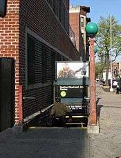
This station has a full-length mezzanine above the platforms and tracks with staircases to each side at regular intervals that connect the two fare control areas. The full-time one is at the north (geographical east) end. It has a turnstile bank, token booth, two staircases going up to the western corners of Nostrand and Lafayette Avenues, and two more staircases going up to the eastern corners of Nostrand and Lafayette Avenues that have since been boarded up.[5] The fare control area at the south (geographical west) end of the mezzanine is unstaffed, containing just full height turnstiles and staircases to all corners of Bedford and Lafayette Avenues.[6][7][8] However, the two staircases on the western corners have been boarded up.[8] They had been previously exit-only. A gate seals off the passageway towards the stairs.
Middle track and expansion provisions
The middle track is used for storage of rush hour trains, or for maintenance and refuse trains. West (railroad south) of this station, the center track has switches to the two outer tracks before ending at a bumper block, while the trackway continues into Classon Avenue. East (railroad north) of the station, the middle track splits into two tracks that ramp down under the outer tracks before those tracks curve north. The tail tracks continue to Marcy Avenue and end at bumper blocks.[7][9][10] A signal and switch tower is located in the tunnel north of the station, staffed during rush hour and midday service, but primarily used during construction reroutes if trains need to be terminated at the station.[11][12][13][14]
Unused in regular service, the middle and tail tracks were originally intended for an unbuilt extension proposed in the IND Second System. Not part of the first official plan in 1929, it was proposed by the city Board of Transportation on October 12, 1930 as an addition to the original plans.[9][15] The plan was for a line to continue east along Lafayette Avenue to Broadway (at Kosciusko Street of the BMT Jamaica Line), then northeast along Stanhope Street to a junction with the BMT Myrtle Avenue Line and a planned IND Myrtle-Central Avenues Line along Myrtle Avenue (between the Central Avenue and Knickerbocker Avenue stations). The IND would then run east along Myrtle Avenue past the Myrtle El, then along Central Avenue in Queens (as opposed to Central Avenue in Brooklyn) to 73rd Place and Cooper Avenue in Glendale, Queens, adjacent to the Long Island Rail Road's Montauk Branch. The line would have likely continued along or parallel to the Montauk and Rockaway Beach Branches of the LIRR to Rockaway Beach and Far Rockaway.[9][15][16][17] Upon completion of the extension, the center track would have been used to terminate short-run trains, or to provide an additional track to hold trains during peak hours.[15]
References
- 1 2 "New Crosstown Subway Line Is Opened". Brooklyn Daily Eagle. July 1, 1937. Retrieved December 24, 2015.
- ↑ "Station Developers' Information". Metropolitan Transportation Authority. Retrieved June 13, 2017.
- ↑ "NYC Subway Wireless – Active Stations". Transit Wireless Wifi. Retrieved May 18, 2016.
- ↑ "Facts and Figures: Annual Subway Ridership 2012–2017". Metropolitan Transportation Authority. July 12, 2018. Retrieved July 12, 2018.
- ↑ http://forgotten-ny.com/2012/09/old-and-on-a-train/
- ↑ "MTA Neighborhood Maps: Bedford Stuyvesant" (PDF). Metropolitan Transportation Authority. 2015. Retrieved October 28, 2015.
- 1 2 "Review of the G Line: Appendices" (PDF). Metropolitan Transportation Authority. July 10, 2013. Retrieved October 28, 2015.
- 1 2 "NYC DoT Maps: Bedford-Nostrand Avs (G)" (PDF). mta.info. New York City Department of Transportation. 2016. Retrieved July 5, 2016.
- 1 2 3 Raskin, Joseph B. (November 1, 2013), The Routes Not Taken: A Trip Through New York City's Unbuilt Subway System, Fordham University Press, ISBN 978-0-8232-5369-2
- ↑ Marrero, Robert (January 1, 2017). "472 Stations, 850 Miles" (PDF). B24 Blog, via Dropbox. Retrieved April 27, 2018.
- ↑ "Review of the G Line" (PDF). mta.info. Metropolitan Transportation Authority. July 10, 2013. Retrieved August 2, 2015.
- ↑ Roy, Jessica (February 25, 2015). "Mysterious Subway People Not Going to Hogwarts After All". New York. Retrieved October 28, 2015.
- ↑ Carlson, Jen (February 25, 2015). "Witnesses Describe Portal To Mysterious G Train Platform Between Subway Stations". Gothamist. Archived from the original on November 8, 2015. Retrieved October 28, 2015.
- ↑ Carlson, Jen (February 26, 2015). "Photos: Here's The Mysterious G Train Portal". Gothamist. Archived from the original on October 17, 2015. Retrieved October 28, 2015.
- 1 2 3 Blackford, Harold J. (October 12, 1930). "Shortline Tube To Link Queens To Stores Here: Altered City Subway Plan Provides Easier Way to Shopping Center". Brooklyn Daily Eagle. pp. 1, 2. Retrieved October 27, 2015 – via Newspapers.com.
- ↑ Duffus, R.L. (September 22, 1929). "OUR GREAT SUBWAY NETWORK SPREADS WIDER; New Plans of Board of Transportation Involve the Building of More Than One Hundred Miles of Additional Rapid Transit Routes for New York" (PDF). The New York Times. Retrieved August 19, 2015.
- ↑ Board of Transportation of the City of New York Engineering Department, Proposed Additional Rapid Transit Lines And Proposed Vehicular Tunnel, dated August 23, 1929
External links
| Wikimedia Commons has media related to Bedford–Nostrand Avenues (IND Crosstown Line). |
- nycsubway.org – IND Crosstown: Bedford–Nostrand Aves.
- Station Reporter — G Train
- The Subway Nut — Bedford–Nostrand Avenues Pictures
- Bedford Avenue entrance from Google Maps Street View
- Nostrand Avenue entrance from Google Maps Street View
- Platforms from Google Maps Street View
Crosstown |
|
|---|---|
| |
| Crosstown Line |
|
|---|---|
| |