67th Avenue (IND Queens Boulevard Line)
67 Avenue | |||||||||||
|---|---|---|---|---|---|---|---|---|---|---|---|
|
| |||||||||||
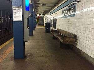 The Manhattan bound platform at 67th Avenue | |||||||||||
| Station statistics | |||||||||||
| Address |
67th Avenue & Queens Boulevard Forest Hills, NY 11375 | ||||||||||
| Borough | Queens | ||||||||||
| Locale | Forest Hills, Rego Park | ||||||||||
| Coordinates | 40°43′37″N 73°51′13″W / 40.726966°N 73.853703°WCoordinates: 40°43′37″N 73°51′13″W / 40.726966°N 73.853703°W | ||||||||||
| Division | B (IND) | ||||||||||
| Line | IND Queens Boulevard Line | ||||||||||
| Services |
E M R | ||||||||||
| Transit connections |
| ||||||||||
| Structure | Underground | ||||||||||
| Platforms | 2 side platforms | ||||||||||
| Tracks | 4 | ||||||||||
| Other information | |||||||||||
| Opened | December 31, 1936 | ||||||||||
| Station code | 262[1] | ||||||||||
| Wireless service |
| ||||||||||
| Traffic | |||||||||||
| Passengers (2017) |
2,695,321[4] | ||||||||||
| Rank | 191 out of 425 | ||||||||||
| Station succession | |||||||||||
| Next east |
Forest Hills–71st Avenue: E | ||||||||||
| Next west |
63rd Drive–Rego Park: E | ||||||||||
| |||||||||||
| |||||||||||
| |||||||||||


67th Avenue is a local station on the IND Queens Boulevard Line of the New York City Subway. Located at the intersection of 67th Avenue and Queens Boulevard in Forest Hills, Queens, it is served by the M train on weekdays, the R train at all times except nights, and the E train at night.
History
The Queens Boulevard Line was one of the first lines built by the city-owned Independent Subway System (IND),[5][6][7] and stretches between the IND Eighth Avenue Line in Manhattan and 179th Street and Hillside Avenue in Jamaica, Queens.[5][7][8] The Queens Boulevard Line was in part financed by a Public Works Administration (PWA) loan and grant of $25,000,000.[9] On December 31, 1936, the IND Queens Boulevard Line was extended by eight stops, and 3.5 miles (5.6 km), from its previous terminus at Roosevelt Avenue to Union Turnpike, and the Grand Avenue station opened as part of this extension.[10][11][12][13][14][15]
Under the 2015–2019 MTA Capital Plan, the station, along with thirty other New York City Subway stations, will undergo a complete overhaul and would be entirely closed for up to 6 months. Updates would include cellular service, Wi-Fi, charging stations, improved signage, and improved station lighting.[16][17] However, these renovations are being deferred until the 2020–2024 Capital Program due to a lack of funding.[18]
Station layout
| G | Street level | Exit/entrance |
| M | Mezzanine | Fare control, station agent, MetroCard machines |
| P Platform level |
Side platform, doors will open on the right | |
| Southbound local | ← ← ← | |
| Southbound express | ← | |
| Northbound express | | |
| Northbound local | | |
| Side platform, doors will open on the right | ||
The station has four tracks and two side platforms. The two center express tracks are used by the E train during daytime hours and the F train at all times.[19] Black columns separate them from the local tracks, some of which have a "67TH AVE" sign on them in black lettering on a white background.
The platforms' trim lines are Medium Powder Blue with a black border. The name tablets have "67TH AVE." in white sans serif font on a black background and teal blue border. There are directional and station signs beneath them in white lettering on a black background. Dark blue I-beam columns run along both platforms for their entire length with alternating ones having the standard black name plate in white lettering.
Exits
The station has a full length mezzanine, which also have dark blue I-beam columns, above the platforms. There are six staircases to each platform and the fare control areas are at either ends. The full-time one is at the west (railroad south) end. It has a turnstile bank, token booth, and two street stairs to either eastern corner of Queens Boulevard and 67th Avenue. The station's other fare control area at the east (railroad north) end is un-staffed, containing full height turnstiles, no booth, and two street stairs to either eastern corner of Queens Boulevard and 67th Drive.[20]
References
- ↑ "Station Developers' Information". Metropolitan Transportation Authority. Retrieved June 13, 2017.
- ↑ "NYC Subway Wireless – Active Stations". Transit Wireless Wifi. Retrieved May 18, 2016.
- ↑ More Subway Stations in Manhattan, Bronx in Line to Get Online, mta.info (March 25, 2015). "The first two phases included stations in Midtown Manhattan and all underground stations in Queens with the exception of the 7 Main St terminal."
- ↑ "Facts and Figures: Annual Subway Ridership 2012–2017". Metropolitan Transportation Authority. July 12, 2018. Retrieved July 12, 2018.
- 1 2 Duffus, R.L. (September 22, 1929). "OUR GREAT SUBWAY NETWORK SPREADS WIDER; New Plans of Board of Transportation Involve the Building of More Than One Hundred Miles of Additional Rapid Transit Routes for New York". The New York Times. Retrieved August 19, 2015.
- ↑ "QUEENS SUBWAY WORK AHEAD OF SCHEDULE: Completion Will Lead to Big Apartrnent Building, Says William C. Speers". The New York Times. April 7, 1929. Retrieved September 1, 2015.
- 1 2 "Queens Lauded as Best Boro By Chamber Chief". Brooklyn Daily Eagle. September 23, 1929. p. 40. Retrieved October 4, 2015 – via Newspapers.com.
- ↑ "New Subway Routes in Hylan Program to Cost $186,046,000" (PDF). The New York Times. March 21, 1925. p. 1.
- ↑ "TEST TRAINS RUNNING IN QUEENS SUBWAY; Switch and Signal Equipment of New Independent Line Is Being Checked". The New York Times. December 20, 1936. ISSN 0362-4331. Retrieved April 26, 2016.
- ↑ "NEW RETAIL AREA IN QUEENS BOROUGH; Sees Roosevelt Avenue Subway Station as Great Shopping Centre. ADVANTAGES POINTED OUT Accessibility to Many Home Communities Assures Potential Market". The New York Times. July 9, 1933. ISSN 0362-4331. Retrieved April 26, 2016.
- ↑ "Reproduction Poster of Extension to Union Turnpike – Kew Gardens". Flickr – Photo Sharing!. Retrieved April 26, 2016.
- ↑ Roger P. Roess; Gene Sansone (August 23, 2012). The Wheels That Drove New York: A History of the New York City Transit System. Springer Science & Business Media. pp. 416–417. ISBN 978-3-642-30484-2.
- ↑ "PWA Party Views New Subway Link: Queens Section to Be Opened Tomorrow Is Inspected by Tuttle and Others" (PDF). The New York Times. December 30, 1936. Retrieved June 27, 2015.
- ↑ "CITY SUBWAY OPENS QUEENS LINK TODAY; Extension Brings Kew Gardens Within 36 Minutes of 42d St. on Frequent Trains". The New York Times. December 31, 1936. ISSN 0362-4331. Retrieved April 26, 2016.
- ↑ "OPENING MOVED UP FOR NEW SUBWAY; Traffic to Be Started on the Extension of City's Line to Kew Gardens on Thursday. EIGHT STATIONS ARE ADDED La Guardia and Official Party Will Inspect New Queens Branch on Wednesday". The New York Times. December 26, 1936. ISSN 0362-4331. Retrieved April 26, 2016.
- ↑ "MTA Will Completely Close 30 Subway Stations For Months-Long "Revamp"". Gothamist. Archived from the original on August 1, 2016. Retrieved July 18, 2016.
- ↑ "MTAStations" (PDF). governor.ny.gov. Government of the State of New York. Retrieved July 18, 2016.
- ↑ Berger, Paul (April 3, 2018). "New York Subway Cuts Back Plans to Renovate Stations". Wall Street Journal. ISSN 0099-9660. Retrieved April 3, 2018.
- ↑ Dougherty, Peter (2002). "NYC Track Map Book Page 50 Queens F" (PDF). nyctrackmapbook.com. Archived from the original (PDF) on April 6, 2003. Retrieved July 3, 2016.
- ↑ "MTA Neighborhood Maps: Forest Hills" (PDF). mta.info. Metropolitan Transportation Authority. 2015. Retrieved July 6, 2015.
External links
| Wikimedia Commons has media related to 67th Avenue (IND Queens Boulevard Line). |
- nycsubway.org – IND Queens Boulevard Line: 67th Avenue
- Station Reporter — R Train
- Station Reporter — M Train
- The Subway Nut — 67th Avenue Pictures
- 67th Avenue entrance from Google Maps Street View
- 67th Drive entrance from Google Maps Street View
- Platforms from Google Maps Street View