BMT Brighton Line
| BMT Brighton Line | |
|---|---|
  | |
| Overview | |
| Type | Rapid transit line |
| System | New York City Subway |
| Status | Operational |
| Locale | Brooklyn, New York City, NY |
| Termini |
DeKalb Avenue Coney Island–Stillwell Avenue |
| Stations | 20 |
| Operation | |
| Opened | July 2, 1878 |
| Owner | City of New York |
| Operator(s) | New York City Transit Authority |
| Character |
Open cut, underground, embankment and elevated |
| Technical | |
| Number of tracks | 2-6 |
| Track gauge | 4 ft 8 1⁄2 in (1,435 mm) |
| Electrification | 600V DC third rail |
The BMT Brighton Line, also known as the Brighton Beach Line,[1] is a rapid transit line in the B Division of the New York City Subway in Brooklyn, New York City, United States. Local service is provided at all times by the Q train, but is joined by the B express train on weekdays. The Q's segment on the Brighton Line begins at the line's south end, Coney Island–Stillwell Avenue, and the Q travels the entire line, over the Manhattan Bridge south tracks to the BMT Broadway Line. The B begins at Brighton Beach and runs via the bridge's north tracks to the IND Sixth Avenue Line.
History
BMT Brighton Line | |||||||||||||||||||||||||||||||||||||||||||||||||||||||||||||||||||||||||||||||||||||||||||||||||||||||||||||||||||||||||||||||||||||||||||||||||||||||||||||||||||||||||||||||||||||||||||||||||||||||||||||||||||||||||||||||||||||||||||||||||||||||||||||||||||||||||||||||||||||||||||||||||||||||||||||||||||||||||||||||||||||||||||||||||||||||||||||||||||||||||||||||||||||||||||||||||||||||||||||||||||||||||||||||||||||||||||||||||||||||||||||||||||||
|---|---|---|---|---|---|---|---|---|---|---|---|---|---|---|---|---|---|---|---|---|---|---|---|---|---|---|---|---|---|---|---|---|---|---|---|---|---|---|---|---|---|---|---|---|---|---|---|---|---|---|---|---|---|---|---|---|---|---|---|---|---|---|---|---|---|---|---|---|---|---|---|---|---|---|---|---|---|---|---|---|---|---|---|---|---|---|---|---|---|---|---|---|---|---|---|---|---|---|---|---|---|---|---|---|---|---|---|---|---|---|---|---|---|---|---|---|---|---|---|---|---|---|---|---|---|---|---|---|---|---|---|---|---|---|---|---|---|---|---|---|---|---|---|---|---|---|---|---|---|---|---|---|---|---|---|---|---|---|---|---|---|---|---|---|---|---|---|---|---|---|---|---|---|---|---|---|---|---|---|---|---|---|---|---|---|---|---|---|---|---|---|---|---|---|---|---|---|---|---|---|---|---|---|---|---|---|---|---|---|---|---|---|---|---|---|---|---|---|---|---|---|---|---|---|---|---|---|---|---|---|---|---|---|---|---|---|---|---|---|---|---|---|---|---|---|---|---|---|---|---|---|---|---|---|---|---|---|---|---|---|---|---|---|---|---|---|---|---|---|---|---|---|---|---|---|---|---|---|---|---|---|---|---|---|---|---|---|---|---|---|---|---|---|---|---|---|---|---|---|---|---|---|---|---|---|---|---|---|---|---|---|---|---|---|---|---|---|---|---|---|---|---|---|---|---|---|---|---|---|---|---|---|---|---|---|---|---|---|---|---|---|---|---|---|---|---|---|---|---|---|---|---|---|---|---|---|---|---|---|---|---|---|---|---|---|---|---|---|---|---|---|---|---|---|---|---|---|---|---|---|---|---|---|---|---|---|---|---|---|---|---|---|---|---|---|---|---|---|---|---|---|---|---|---|---|---|---|---|---|---|---|---|---|---|---|---|---|---|---|---|---|---|---|---|---|---|---|---|---|---|---|---|---|---|---|---|---|---|---|---|---|---|---|---|---|---|---|---|---|---|---|---|---|
| |||||||||||||||||||||||||||||||||||||||||||||||||||||||||||||||||||||||||||||||||||||||||||||||||||||||||||||||||||||||||||||||||||||||||||||||||||||||||||||||||||||||||||||||||||||||||||||||||||||||||||||||||||||||||||||||||||||||||||||||||||||||||||||||||||||||||||||||||||||||||||||||||||||||||||||||||||||||||||||||||||||||||||||||||||||||||||||||||||||||||||||||||||||||||||||||||||||||||||||||||||||||||||||||||||||||||||||||||||||||||||||||||||||
Origins

The Brighton Line opened from the Willink entrance of Prospect Park (modern intersection of Flatbush and Ocean Avenues and Empire Boulevard, now the Prospect Park station on both the renamed Brighton and the Franklin Ave. Shuttle lines) to Brighton Beach (modern Coney Island Avenue at the shoreline) on July 2, 1878 and the full original line on August 18. It was an excursion railroad — the Brooklyn, Flatbush and Coney Island Railway — to bring beachgoers from downtown Brooklyn (via a connection with the Long Island Rail Road) to the seashore at Coney Island on the Atlantic Ocean, at a location named Brighton Beach at the same time the railroad arrived. It has been known since its opening as the Brighton Beach Line but is now described as the Brighton Line in MTA literature and in public usage.
After losing its connection with the Long Island Rail Road in 1883, the railroad fell on hard times, reorganizing as the Brooklyn and Brighton Beach Railroad. Seeking a new route for its excursion business and its local trade in communities along the way, it formed an agreement with the Kings County Elevated Railway to connect to its Fulton Street Line, which gave access to the new Brooklyn Bridge and Manhattan passengers. This was accomplished in 1896.
A series of mergers and leases put the Brighton Beach Line in the hands of the Brooklyn Rapid Transit Company (BRT), a holding company which eventually controlled most of the rapid transit, streetcar, and bus lines in Brooklyn and part of Queens. The line was electrified with trolley wire and, for a time, trolleys from several surface routes and elevated trains operated together on the line.
The BRT was reorganized as the Brooklyn–Manhattan Transit Corporation (BMT) in 1923. In 1940, the BMT was purchased by the City of New York, and operation passed to the city's Board of Transportation, which already operated the city-built Independent Subway System (IND).
The original line was a two-tracked high-speed surface steam railroad operating from Bedford Station, at Atlantic Avenue near Franklin Avenue in the City of Brooklyn, at which point it made a physical connection to the Long Island Rail Road's Atlantic Branch. From Bedford the line ran on a surface private right-of-way several blocks south to Park Place, which it crossed at grade, and then in an open cut with street overpasses through what is now Crown Heights and Flatbush, as far as Church Lane (now Church Avenue) in the Town and Village of Flatbush. From that point the line continued on the surface to a point at current Beverley Road between Marlborough Road (East 15th Street) and East 16th Street, curving southeast and running on the surface between the lines of the latter streets through the Towns of Flatbush and Gravesend to Sheepshead Bay, then turning southerly to reach the beach at Brighton Beach on Coney Island in the Town of Gravesend.
The line was extended westward from Brighton Beach in 1903, so that it could terminate with the former Prospect Park and Coney Island Railroad at Culver Depot in Coney Island. Passengers, with this short extension, were given access to the developing area of Coney Island. The Culver Depot became the center of operations for the Culver Line and the Brighton Beach Line.[2]
Grade crossing eliminations, 1903-08 and 1918-20
In 1903, the New York State Legislature created the Brooklyn Grade Crossing Elimination Commission (BGCEC) to eliminate grade all grade crossings on the Brighton Beach Line and the Bay Ridge Line of the Long Island Rail Road. The city was supposed to cover half of the costs, not exceeding $1,000,000, while the railroads were to cover the other half of the costs. The work started on December 30, 1905, and was completed in 1908. A short piece of two-tracked elevated railroad was built from the ramp connecting to the Fulton Street Elevated as far as Park Place, where the original 1878 open cut began. From the end of that original cut south of Church Avenue, the line was wholly rebuilt as a four-track railroad with express and local stations to a point south of Neptune Avenue at the border of Coney Island, continuing along its original right-of-way to Brighton Beach station. The portion from Church Avenue to Avenue H was placed in a depressed open cut, while the portion from Avenue H to south of Sheepshead Bay was raised onto an earthen embankment, primarily with earth excavated from the open-cut portion and from the Bay Ridge Improvement of the Long Island Rail Road. The separation of the railroad grade allowed the line's trolley wire north of Sheepshead Bay to be replaced with ground-level third rail.[2]
The above work by the BGCEC left the line between Park Place and Church Avenue in substantially its original condition from steam railroad days. Between 1918 and 1920, however, further work rebuilt the portion between Prospect Park and Church Avenue as a four-track line. At the same time, the remaining portion of the line south of Neptune Avenue was replaced with a four-track elevated structure, including a four- to six-track elevated line extension, connecting the Brighton Line to the new Coney Island terminal at Surf and Stillwell Avenues. This same work rerouted mainline Brighton Beach trains from the Fulton Street elevated line via a new deep tunnel under Flatbush Avenue to connect to the BMT Fourth Avenue Line at DeKalb Avenue station, where trains could access the new BMT Broadway subway. This work was done as a part of the Dual Contracts.
A spur south of Neck Road, which split to Sheepshead Bay Race Track, was in use from 1909 to around 1929. The single-track spur was part of the Long Island Rail Road's Manhattan Beach Branch, and it ran along the street to Ocean Avenue between Avenues X and Y, where it terminated at a six-track terminal.[3]:2
Brighton–Franklin Line
The St. Felix Street and Flatbush Avenue Connection opened on August 1, 1920, providing direct service between the Brighton Line and midtown Manhattan.[1][4] With the opening of the connection, the original portion of the line between the Fulton Street Elevated and the link to the new subway at Prospect Park became a secondary line, known as Brighton–Franklin, and now known as the BMT Franklin Avenue Line. At times through services (including expresses) operated on mainline Brighton tracks to Coney Island. Some special weekend trains even operated beyond Coney Island back to Manhattan via the BMT Sea Beach Line express tracks and the BMT Fourth Avenue Subway. This service was variously known as Franklin–Nassau and as the Coney Island Express, but its popular name was the "Sunny Sunday Summer Special," because it was only supposed to operate as needed on the hottest beach-going days.
Through services gradually diminished on the Brighton–Franklin, and after 1963 it became a pure shuttle, operating between Franklin Avenue station at Fulton Street and Prospect Park station, where it connects with mainline Brighton Beach trains.
During the era of route contraction from 1940 to about 1975, the Franklin Avenue Shuttle seemed a prime candidate for abandonment; its physical structure had been allowed to deteriorate and its service steadily curtailed. The New York City fiscal crisis of the '70s and the recession in 1990 contributed to plans to discontinue the line. By the 1990s the Franklin Avenue Shuttle was known as the "ghost train". It was shrunk in size to only two cars and the Dean Street station was closed. The entire line was under consideration for abandonment, but community pressure forced the MTA to rebuild rather than abandon the line, and as a result, most of the supporting infrastructure and stations were completely rehabilitated in 1998–1999 at a cost of $74 million and reopened in 1999.[5]
Platform extensions, track repairs, and Stillwell Avenue reconstruction
During the 1964–1965 fiscal year, the platforms at the Atlantic Avenue, Seventh Avenue, Parkside Avenue, Church Avenue, Beverley Road, Cortelyou Road, and Newkirk Avenue stations were lengthened to 615 feet to accommodate a ten-car train of 60-foot IND cars, or a nine-car train of 67-foot BMT cars. At the time, work continued on the platform extensions for Avenue H, Avenue J, Avenue M, Kings Highway, Avenue U, Neck Road, Brighton Beach, Ocean Parkway, West 8th Street and Stillwell Avenue.[6]
In 1986, service was disrupted due to track repairs and other construction work along the line. The two local tracks were completely rebuilt between Prospect Park and Newkirk Avenue, in two phases, with the Manhattan-bound track rebuilt first. A temporary platform was built at Cortelyou Road while Beverley Road and Parkside Avenue were closed in one direction. To reduce congestion, skip-stop service was implemented on weekdays, which lasted until 1988.[7]
From September 8, 2002 to May 23, 2004, service was suspended west of Brighton Beach due to allow rebuilding of the Coney Island–Stillwell Avenue terminal station, which had deteriorated due to the effects of salt water corrosion and deferred maintenance.[8]
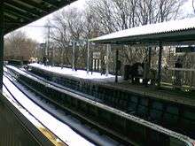
Brighton Line Station Reconstruction Project
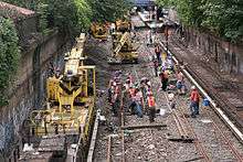
.jpg)
In 2007, the MTA announced that it would reconstruct seven stations between Newkirk Avenue and Neck Road, inclusive.[9] On December 8, 2008, the first phase of the Brighton Line Station Reconstruction Project began. The Coney Island-bound platforms of Avenue U and Neck Road were closed for rebuilding and all southbound trains ran on the express track from Kings Highway to Sheepshead Bay.
On September 14, 2009, the second phase of the project involving all stations between Kings Highway and Newkirk Plaza began, requiring all trains to run local until Fall 2011.[10] Over the next two weeks, temporary platforms were placed on the Manhattan-bound express track at Kings Highway and Avenue J for southbound service. On September 28, the southbound platforms of Avenue H, Avenue J, Avenue M, and Kings Highway began rebuilding. South of Cortelyou Road, a single crossover connected the southbound local track with the express one and all southbound trains skipped Avenue H and Avenue M.
On January 18, 2010, Coney Island-bound service was restored at Avenue U and Neck Road. The Manhattan-bound platforms were closed for rebuilding until October 25 and all northbound trains operated on the express track from Sheepshead Bay to Kings Highway.
On September 13, Coney Island-bound service to Avenue H and Avenue M was restored and the two southbound tracks south of Cortelyou Road were separated. Over the next two weeks, the temporary platforms at Avenue J and Kings Highway were moved to the southbound express track and the two northbound tracks were connected to each other north of Newkirk Plaza. On September 27, the Manhattan-bound platforms of those three stations as well as Avenues H and M, which were then being bypassed, began rehabilitation and all northbound service was directed to the express track until Cortelyou Road. The platforms of all stations reopened on September 12, 2011 and B express service was restored on October 3. However, rehabilitation work that did not affect service continued until the end of the year.
Service patterns
The following services use part or all of the Brighton Line:[11]
| Service | Section of line | |||
|---|---|---|---|---|
| Weekdays | Weekends | Late Nights | ||
| express | no service | north of Brighton Beach | ||
| local | entire line | |||
Since 1920, the primary service on the line has been through to Manhattan rather than over the tracks now used by the Franklin Avenue Shuttle. Local service has run all the time, while express service has generally been provided during weekday rush hours and later middays. Until the 1960s, all service on the line north of Prospect Park was labeled 1.
Standard local service ran through the Montague Street Tunnel and along the BMT Broadway Line local tracks; service instead crossed the Manhattan Bridge north tracks and ran express under Broadway during Broadway theatre hours (7:30 pm to midnight). Over the years, the local bridge service was expanded, and the local tunnel service ended up only from 6 am to 7 pm. Express service over the bridge to the Broadway express tracks, initially during rush hours, was also expanded to 6 am to 7 pm. The three patterns were assigned latter designations in the early 1960s: Q express via bridge, QT local via tunnel, and QB local via bridge.
The Chrystie Street Connection opened in late 1967, and almost all Brighton Line trains were removed from Broadway. The Q and QB were both combined with the D on the IND Sixth Avenue Line, running express during the day and local at other times. The daytime QT local was combined with the J and JJ to form the QJ, running through the tunnel to the BMT Nassau Street Line. The only Brighton-Broadway service was a new QB, running in the peak direction at rush hours on the local Brighton and express Broadway tracks. (The two QB services were distinct; the old QB had run at non-peak times; this new QB had the same name and almost the same route but was a different service.)
The QJ's Brighton section was replaced with an extension of the M in 1973. In 1985, the QB was renamed Q as the subway eliminated the double letter naming system for local routes.[12] Reconstruction of the Manhattan Bridge subway tracks began, which would continue until 2004. Though the same general service patterns remained on the Brighton Line, all trains were sent over the bridge and onto the Broadway or Sixth Avenue Line, depending on which set of tracks was open. From 1986 to 1988, the south side (Broadway) was in service, and the D continued to serve the line at all times, the M was rerouted onto the BMT Fourth Avenue Line and Q service now also ran during middays. Because of the concurrent track and infrastructure repairs on the Brighton Line, express service was suspended for two years. As tracks between Prospect Park and Newkirk Avenue were rebuilt, the D and Q provided skip-stop service between Newkirk Avenue and Sheepshead Bay on weekdays. D trains served Neck Road, Avenue M and Avenue H; the Q skipped those stops, serving Avenue U and Avenue J, while both trains served Kings Highway.[7] By 1987, as the line's reconstruction progressed, the weekday skip-stop pattern expanded to Prospect Park, with D trains serving Beverley Road while Q trains served Cortelyou Road and Parkside Avenue, with Church Avenue as a mutual station.[13]
In 1988, the Bridge's north (Sixth Avenue) tracks reopened; at this time, the skip-stop pattern was eliminated, and the D became a full-time local service to Stillwell Avenue, while the Q ran express on weekdays to Brighton Beach. Both trains ran via Sixth Avenue Express. From April 30 to November 12, 1995, the Manhattan Bridge fully closed during middays and weekends. D service in Brooklyn was suspended during these hours; the Q replaced it, running local to Stillwell Avenue and via the Montague Street Tunnel and Broadway Express.[14][15]
The 2001 shifting of trains back to the south side (Broadway) led to the D only running north of Midtown Manhattan; the Q replaced the D as the full-time Brighton Local while the Brighton express portion of the Q became the diamond <Q>. When both sides of the bridge reopened in 2004, the <Q> was discontinued and replaced by the B in Brooklyn. The B was moved to the Brighton rather than the West End Line, where it ran from 1967 to 2001, to combine two weekday-only services and because Brighton Line residents preferred Broadway Service, the Q was kept as the full-time local. [16]
Description

The modern-day line shows a mix of its various re-buildings.
DeKalb Avenue to Prospect Park
The underground portion from the DeKalb Avenue connection to the BMT Fourth Avenue Line was built in 1920 as part of the Dual Contracts. This section contains two additional stations: the Atlantic Avenue–Barclays Center and Seventh Avenue. Between Atlantic Avenue and Grand Army Plaza, the Brighton Line tunnel runs beside, under, and between the tracks of the Interborough Rapid Transit Company (IRT)'s Eastern Parkway Line.[17] The Eastern Parkway Line was built simultaneously with this part of the Brighton Line, and also opened in 1920.[18]
At Prospect Park, the Brighton subway tunnel emerges into an open cut. The Prospect Park station contains a cross-platform interchange with the BMT Franklin Avenue Line, which is used by the S train. Franklin Avenue Line trains use the northbound local track, while the express tracks in both directions are used by the Brighton Line trains; the southbound local track is not in service.[17] The former alignment of the Brighton Line ran along what is now the Franklin Avenue Line, which had been built as a surface railway in 1878 and rebuilt as a grade-separated open-cut and embankment line in 1905.
Prospect Park to Brighton Beach
South of Prospect Park, the Brighton Line widens to a four-track line for much of the rest of the route. The B continues on the inner tracks and runs to Brighton Beach, serving only express stations, while the Q splits to the outer tracks, serving all stops until the end of the line at Coney Island–Stillwell Avenue. The original line built in 1878 ran in a two-track open cut. This segment was rebuilt in 1918 to 1920 to a four track line with an express station at Prospect Park, a local station at Parkside Avenue (replacing the original station at Woodruff Avenue) and another express station at Church Avenue. The line features slightly sloped and capped reinforced concrete walls, as well as cut-and-cover tunnels underneath cross-streets.
The segment between Church Avenue to Avenue H is a result of the BGCEC rebuilding program of 1903–1907. Just south of the tunnel under Church Avenue, the construction of the cut wall visibly changes. Steel trestles carry the streets above the line, giving it a more open appearance. Cottage-style station houses are suspended over the line at local stations at Beverley and Cortelyou Roads, and at the express station at Newkirk Plaza. Past Newkirk Plaza the line continues in an open cut, then begins to rise to street level at the north end of Avenue H station.[17]
The station house at Avenue H is a wooden structure built in 1905 and originally housed a real estate office for the sale of homes in the new Fiske Terrace community surrounding the station. The building was designated a landmark by the New York City Landmarks Preservation Commission in 2004. At this point the line now runs on an earthen embankment with local stations at Avenue H, Avenue J and Avenue M, an express station at Kings Highway, local stops at Avenue U and (Gravesend) Neck Road, and an express station at Sheepshead Bay (formerly Shore Road).[17] All of the station houses for these stops are located beneath the tracks at street level.
The line continues south on the 1907 embankment to a bridge over Neptune Avenue. At this point the BGCEC roadbed ends. Prior to the Dual Contracts rebuild in the late 1910s, the line descend to the surface on two single track concrete and steel ramps to operate on the surface to Brighton Beach. As part of the 1918–1920 Dual Contracts work, all four tracks now continue on a steel elevated structure to the junction of Coney Island and Brighton Beach Avenues, where the line turns west onto Brighton Beach Avenue and enters the Brighton Beach station.
Brighton Beach to Coney Island
Traveling west from Brighton Beach station, the line operates on a six track elevated structure over Brighton Beach Avenue. One track splits from each pair of local and express tracks in each direction. Only the outer two tracks are currently used for revenue service, carrying Q trains. The inner four are layup tracks used to store B trains that terminate at Brighton Beach; the innermost two tracks were originally.[17] This is the former right-of-way of the Sea View Railway which originally provided service west of Brighton Beach.
Each of the two layup tracks between the local and express tracks ends before Ocean Parkway station, while the innermost and outermost tracks stop at the station. The outer tracks merge with the inner tracks, and the inner tracks climb to an upper level. The outer trackways remain at the same elevation, and shortly afterward merge with the two tracks of the IND Culver Line (F train), which merge into the structure from the north. Both lines then stop at the West Eighth Street–New York Aquarium station, a double-level steel structure with two tracks on each level. The Brighton trains occupy the upper level and the Culver Line trains the lower.[17] Both lines then enter the 8-track Stillwell Avenue terminal, which was built in 1917–1920 and renovated in 2001–2004. The Brighton trains occupy tracks 3 and 4.[17]
Chaining information
The entire main line of the Brighton Line (excluding the Franklin Avenue Shuttle) is "chained" BMT A.[17] This has no relation to the letters assigned to the services on the Brighton Line, which are B for the weekday Sixth Avenue service and Q for the full-time Broadway service.
Chaining zero is BMT Southern, located just north of the 57th Street–Seventh Avenue station of the BMT Broadway Line via the Manhattan Bridge. The Brighton Line picks up this chaining south of DeKalb Avenue station.[17]
Railroad north is toward Manhattan, generally corresponding to compass north-northwest.[17]
Brighton Beach terminal's BMT telegraphy call letters were BC and in the past the entire Brighton Line had been referred to by the letters BC as a shorthand notation in internal documents. This has gradually diminished and is now uncommon.
Tracks on the Brighton Line are numbered as follows:[17]
- Odd numbered tracks are away from Manhattan (southbound)
- Even numbered tracks are toward Manhattan (northbound)
- Tracks 1 and 2 are usually local (outside tracks, shown in Roman type)
- Tracks 3 and 4 are usually express (inside tracks, shown in bold type)
- Non-revenue tracks are shown in italic type
| From | To | Track arrangement | Line orientation | Comments |
|---|---|---|---|---|
| DeKalb Avenue | Prospect Park | A3-A4 | NNW | no local tracks |
| Prospect Park | Brighton Beach | A1-A3-A4-A2 | NNW | local tracks for Franklin Avenue Line in Prospect Park station only |
| Brighton Beach | Ocean Parkway | A1-A5-A3-A4-A6-A2 | WSW | A3-A4 were originally express tracks; A5-A6 are layup tracks |
| Ocean Parkway | West Eighth Street–New York Aquarium (upper level) | A3-A4 | WSW | |
| Ocean Parkway | West Eighth Street–New York Aquarium (lower level) | A1-A2 | WSW | abandoned 1954; trackbeds only |
| West Eighth Street–New York Aquarium (upper level) | Coney Island–Stillwell Avenue (C-D tracks) | A3-A4 | WSW | All Brighton line trains |
| West Eighth Street–New York Aquarium (lower level) | Coney Island–Stillwell Avenue (E-F tracks) | A1-A2 | WSW | now used by IND Culver Line (F) trains only |
Station listing
| Station service legend | |
|---|---|
| Stops all times | |
| Stops all times except late nights | |
| Stops late nights only | |
| Stops weekdays only | |
| Stops rush hours only | |
| Time period details | |
| Station is compliant with the Americans with Disabilities Act | |
| Station is compliant with the Americans with Disabilities Act in the indicated direction only | |
| Elevator access to mezzanine only | |
| Neighborhood (approximate) |
Station | Tracks | Services | Opened | Transfers and notes | |
|---|---|---|---|---|---|---|
| Begins as a merge of the Montague Street Tunnel (N BMT Broadway Line express tracks via the Manhattan Bridge (N and IND Sixth Avenue Line express tracks via the Manhattan Bridge (B | ||||||
| Downtown Brooklyn | DeKalb Avenue | bridge, tunnel | B |
August 1, 1920[4] | 6 tracks; only four outer tracks stop at this station. Within station, outermost tracks are used by trains using the bridge, and center tracks are used by trains using the tunnel. Innermost tracks are used by BMT Fourth Avenue Line express trains from the bridge. | |
| split with the BMT Fourth Avenue Line (D | ||||||
| Atlantic Avenue–Barclays Center | all | B |
August 1, 1920[1][4] | 2 D Connection to LIRR at Atlantic Terminal | ||
| Park Slope | Seventh Avenue | all | B |
August 1, 1920[1][4] | ||
| Flatbush | Prospect Park | all | B |
July 2, 1878[19] | S Prior to the 1920 expansion, the Brighton Line followed the current Franklin Avenue Line north of this station. | |
| Two Center Express tracks begin (B | ||||||
| Parkside Avenue | local | Q |
by 1895 | |||
| Church Avenue | all | B |
July 2, 1878[19] | Originally called Flatbush station, or sometimes Church lane, Flatbush.[19] | ||
| Beverley Road | local | Q |
by 1899 | |||
| Cortelyou Road | local | Q |
by 1902 | Formerly known as Avenue C station[1] | ||
| Newkirk Plaza | all | B |
July 2, 1878[19] | Originally known as Parkville station[19] | ||
| Midwood | Avenue H | local | Q |
1896 or 1897[20][21] | Station is ADA-accessible in the southbound direction only | |
| Avenue J | local | Q |
August 23, 1907 | |||
| Avenue M | local | Q |
1878[22][23][24] | Originally known as South Greenfield station, and later Elm Avenue station[1] | ||
| Kings Highway | all | B |
July 2, 1878[19] | B82 Select Bus Service Originally described as at Kings Highway, near the Prospect Park Fair Grounds[19] | ||
| Homecrest | Avenue U | local | Q |
by 1898 | Originally known as Gravesend station | |
| Neck Road | local | Q |
July or August 1878[25] | Former transfer to LIRR | ||
| Sheepshead Bay | Sheepshead Bay | all | B |
July 2, 1878[19] | Originally described as at Coney Island Creek, Sheepshead Bay. | |
| Brighton Beach | Brighton Beach | all | B |
July 2, 1878[19] | Originally serviced the Brighton Beach Hotel at this location. | |
| Express tracks continue (No Regular Service) | ||||||
| Ocean Parkway | all | Q |
April 22, 1917 | |||
| Local tracks merge into Express tracks (Local trackways continue to lower level of West Eighth Street) | ||||||
| Coney Island | West Eighth Street–New York Aquarium | all | Q |
May 19, 1919 | F Brighton tracks on upper level | |
| Coney Island–Stillwell Avenue | all | Q |
May 29, 1919 | D F N | ||
See also
References
- 1 2 3 4 5 6 District, New York (State) Public Service Commission First (January 1, 1921). Annual Report for the Year Ended ... The Commission.
- 1 2 Cudahy, Brian J. (January 1, 1999). The Malbone Street Wreck. Fordham Univ Press. ISBN 9780823219322.
- ↑ "BRIGHTON LINE TRACK PLANS BRIGHTON LINE TRACK PLANS" (PDF). Electric Railroaders' Association Bulletin. 46 (7): 2. July 2003. Retrieved April 10, 2018.
- 1 2 3 4 "New Subways Add Seven More Miles to BRT on Aug 1". Brooklyn Daily Eagle. July 25, 1920. Retrieved August 19, 2016 – via newspapers.com.
- ↑ Wilson, Michael (July 24, 2008), "In Brooklyn, It's the Little Train That Can", The New York Times, ISSN 0362-4331, retrieved July 27, 2008
- ↑ Annual Report 1964–1965. New York City Transit Authority. 1965.
- 1 2 "The JoeKorNer Brochures". Retrieved February 8, 2018.
- ↑ "Stillwell Terminal Remains a Sparkling Jewel a Decade after Full Rehabilitation". www.mta.info. Metropolitan Transportation Authority. May 20, 2014. Retrieved August 15, 2016.
- ↑ "Southern Brooklyn Q stops gearing up for renovations". Second Ave. Sagas. December 10, 2007. Retrieved August 11, 2017.
- ↑ "MTA - Press Release - NYC Transit - Temporary Loss of Brighton Line Express". mta.info.
- ↑ "Subway Service Guide" (PDF). Metropolitan Transportation Authority. June 25, 2017. Retrieved July 1, 2017.
- ↑ "Hey, What's a "K" train? 1985 Brochure". Flickr - Photo Sharing!. Retrieved June 17, 2016.
- ↑ Mader, Stewart. "NYC Subway Maps Have a Long History of Including PATH, NJ Waterfront". stewartmader.com. Retrieved February 9, 2018.
- ↑ Ronald Sullivan (March 26, 1995). "Bridge Repairs to Disrupt Off-Peak Subway Service". The New York Times. Retrieved July 2, 2016.
- ↑ "QUEENSBRIDGE / 6TH AVE - BRIGHTON BEACH LINE (Q TRAIN)".
- ↑ "A Subway Map Remade, in Hopes of Matching Routes and Riders". The New York Times. February 20, 2004. Retrieved June 9, 2014.
- 1 2 3 4 5 6 7 8 9 10 11 Dougherty, Peter (2006) [2002]. Tracks of the New York City Subway 2006 (3rd ed.). Dougherty. OCLC 49777633 – via Google Books.
- ↑ "More Interborough Service for Brooklyn 2 New Lines". pudl.princeton.edu. Interborough Rapid Transit Company. August 23, 1920. Retrieved September 19, 2016.
- 1 2 3 4 5 6 7 8 9 "Finished". Brooklyn Daily Eagle. Brooklyn, NY. July 1, 1878. p. 2.
- ↑ "Flatbush Notes". Brooklyn Daily Eagle. Brooklyn, NY. May 16, 1896. p. 7.
- ↑ "Parkville Notes". Brooklyn Daily Eagle. Brooklyn, NY. April 27, 1897. p. 10.
Charles H Severs of Washington avenue has finished work on the railroad station at Fiske Terrace.
- ↑ "The Little Station in the Woods".
- ↑ Seymour, Jr. (State Engineer & Surveyor), Horatio (1879). Annual Report on the Railroads of New York (1878). Albany, NY: New York State / Charles van Benthuysen & Sons. p. 58.
July 11 About half past nine in the evening John Galagher was struck by engine No 4 train No 101 going south at Greenfield and was instantly killed He was standing on the platform when the train approached and when the engine was within fifty feet of him he stepped on the track in front of the train and was struck and instantly killed He was employed on repairs of track at the time Coroner's jury exonerated the company from any blame in the matter
- ↑ "Coney Island: Railroad to Brighton Beach". Brooklyn Daily Eagle. Brooklyn, NY. November 1, 1878. p. 1.
Commencing on Monday October 1, the Brooklyn, Flatbush and Coney Island Railway Company will run trains from Prospect Park Station (Willinks) For Brighton Beach as follows: ... stopping both ways at Flatbush [Church Ave], Parkville [Newkirk], South Greenfield [Avenue M], Gravesend [Avenue U], Neck Road and Sheepshead Bay.
- ↑ "Killed on the Rail". Brooklyn Public Library. The Brooklyn Daily Eagle. August 25, 1878. Retrieved December 26, 2016.
External links
Route map:
| Wikimedia Commons has media related to BMT Brighton Line. |
- nycsubway.org – BMT Brighton Line:
| Current services |
| ||||||||||
|---|---|---|---|---|---|---|---|---|---|---|---|
| Defunct services |
| ||||||||||
| Unused labels | |||||||||||
| Stations |
| ||||||||||
| Divisions | |||||||||||
| Other lists | |||||||||||
| History |
| ||||||||||
| Infrastructure | |||||||||||
| Arts and culture | |||||||||||
| Miscellaneous | |||||||||||
| Other rapid transit in NYC |
| ||||||||||