Steinway Street (IND Queens Boulevard Line)
Steinway Street | |||||||||||
|---|---|---|---|---|---|---|---|---|---|---|---|
|
| |||||||||||
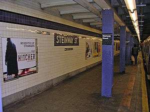 A mosaic at Steinway Street with an R46 R train at the station. | |||||||||||
| Station statistics | |||||||||||
| Address |
Steinway Street & Broadway Queens, NY 11103 | ||||||||||
| Borough | Queens | ||||||||||
| Locale | Astoria | ||||||||||
| Coordinates | 40°45′31″N 73°55′08″W / 40.758668°N 73.918934°WCoordinates: 40°45′31″N 73°55′08″W / 40.758668°N 73.918934°W | ||||||||||
| Division | B (IND) | ||||||||||
| Line | IND Queens Boulevard Line | ||||||||||
| Services |
E M R | ||||||||||
| Transit connections |
| ||||||||||
| Structure | Underground | ||||||||||
| Platforms | 2 side platforms | ||||||||||
| Tracks | 2 | ||||||||||
| Other information | |||||||||||
| Opened | August 19, 1933 | ||||||||||
| Station code | 271[1] | ||||||||||
| Wireless service |
| ||||||||||
| Traffic | |||||||||||
| Passengers (2017) |
4,733,777[4] | ||||||||||
| Rank | 104 out of 425 | ||||||||||
| Station succession | |||||||||||
| Next north |
46th Street: E | ||||||||||
| Next south |
36th Street: E | ||||||||||
| |||||||||||
| |||||||||||
| |||||||||||


Steinway Street is a local station on the IND Queens Boulevard Line of the New York City Subway. Located under Steinway Street between Broadway and 34th Avenue, it is served by the M train on weekdays, the R train at all times except nights, and the E train at night.
History
The Queens Boulevard Line was one of the first lines built by the city-owned Independent Subway System (IND),[5][6][7] and stretches between the IND Eighth Avenue Line in Manhattan and 179th Street and Hillside Avenue in Jamaica, Queens.[5][7][8] The Queens Boulevard Line was in part financed by a Public Works Administration (PWA) loan and grant of $25,000,000.[9] One of the proposed stations would have been located at Steinway Street.
The first section of the line, west from Roosevelt Avenue to 50th Street, opened on August 19, 1933. E trains ran local to Hudson Terminal (today's World Trade Center) in Manhattan, while the GG (predecessor to current G service) ran as a shuttle service between Queens Plaza and Nassau Avenue on the IND Crosstown Line.[10][11][12][13][14][15]
Station layout
| G | Street Level | Exit/Entrance |
| M | Mezzanine | Fare control, station agent |
| P Platform level |
Side platform, doors will open on the right | |
| Southbound local | ← ← ← | |
| Northbound local | → → | |
| Side platform, doors will open on the right | ||
This station has two tracks and two side platforms. The platform tiles are white with a purple trim line and narrow black border. Beneath them are black tiles with the word "STEINWAY" in white. The name tablets have a purple border, white letters, and black tile backgrounds. Purple i-beam columns run at regular intervals along both platforms.
South of this station, the express tracks rejoin the local tracks and the line becomes four tracks again.
Exits
There are two separate mezzanines, one at each end of the station, and crossover is allowed on both of them. The full-time side on Steinway Street near Broadway has two street stairs. This side has two small staircases to the southbound side and a single platform-wide staircase on the northbound side. The part-time side at 34th Avenue and Steinway Street currently has no booth (it had been completely dismantled for asbestos abatement), and is HEET turnstile access at all times. This side has two stairs to the street to the northeast and southwest corners, and one to each platform.[16]
References
- ↑ "Station Developers' Information". Metropolitan Transportation Authority. Retrieved June 13, 2017.
- ↑ "NYC Subway Wireless – Active Stations". Transit Wireless Wifi. Retrieved May 18, 2016.
- ↑ More Subway Stations in Manhattan, Bronx in Line to Get Online, mta.info (March 25, 2015). "The first two phases included stations in Midtown Manhattan and all underground stations in Queens with the exception of the 7 Main St terminal."
- ↑ "Facts and Figures: Annual Subway Ridership 2012–2017". Metropolitan Transportation Authority. July 12, 2018. Retrieved July 12, 2018.
- 1 2 Duffus, R.L. (September 22, 1929). "OUR GREAT SUBWAY NETWORK SPREADS WIDER; New Plans of Board of Transportation Involve the Building of More Than One Hundred Miles of Additional Rapid Transit Routes for New York". The New York Times. Retrieved August 19, 2015.
- ↑ "QUEENS SUBWAY WORK AHEAD OF SCHEDULE: Completion Will Lead to Big Apartrnent Building, Says William C. Speers". The New York Times. April 7, 1929. Retrieved September 1, 2015.
- 1 2 "Queens Lauded as Best Boro By Chamber Chief". Brooklyn Daily Eagle. September 23, 1929. p. 40. Retrieved October 4, 2015 – via Newspapers.com.
- ↑ New York Times, New Subway Routes in Hylan Program to Cost $186,046,000, March 21, 1925, page 1
- ↑ "TEST TRAINS RUNNING IN QUEENS SUBWAY; Switch and Signal Equipment of New Independent Line Is Being Checked". The New York Times. December 20, 1936. ISSN 0362-4331. Retrieved April 26, 2016.
- ↑ Kramer, Frederick A. (1990). Building the Independent Subway. Quadrant Press. ISBN 978-0-915276-50-9.
- ↑ Raskin, Joseph B. (November 1, 2013), The Routes Not Taken: A Trip Through New York City's Unbuilt Subway System, Fordham University Press, ISBN 978-0-8232-5369-2
- ↑ "Independent Subway Services Beginning in 1932". thejoekorner.com. August 21, 2013. Retrieved August 2, 2015.
- ↑ "TWO SUBWAY UNITS OPEN AT MIDNIGHT; Links in City-Owned System in Queens and Brooklyn to Have 15 Stations" (PDF). The New York Times. August 18, 1933. Retrieved November 7, 2015.
- ↑ "New Queens Subway Service Will Be Launched Tonight; Tunnel From Manhattan Open to Jackson Heights; Service Will Eventually Be Extended Through To Jamaica". Long Island Daily Press. Fultonhistory.com. August 18, 1933. p. 20. Retrieved July 27, 2016.
- ↑ "New Queens Tube To Open Saturday: Brooklyn-Long Island City Link of City Line Also to Be Put in Operation". New York Evening Post. Fultonhistory.com. August 17, 1933. p. 18. Retrieved July 27, 2016.
- ↑ "MTA Neighborhood Maps: Long Island City" (PDF). Metropolitan Transportation Authority. 2015. Retrieved September 27, 2015.
External links

- nycsubway.org – IND Queens Boulevard Line: Steinway Street
- Station Reporter — R Train
- Station Reporter — M Train
- The Subway Nut — Steinway Street Pictures
- Broadway entrance from Google Maps Street View
- 34th Avenue entrance from Google Maps Street View
- Platforms from Google Maps Street View
| People | |
|---|---|
| Related places and things | |
| Eponymous places and things | |
| |