75th Avenue (IND Queens Boulevard Line)
75 Avenue | |||||||||
|---|---|---|---|---|---|---|---|---|---|
|
| |||||||||
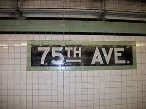 The mosaics at 75th Avenue station | |||||||||
| Station statistics | |||||||||
| Address |
75th Avenue & Queens Boulevard Forest Hills, NY 11375 | ||||||||
| Borough | Queens | ||||||||
| Locale | Forest Hills | ||||||||
| Coordinates | 40°43′07″N 73°50′16″W / 40.71864°N 73.837738°WCoordinates: 40°43′07″N 73°50′16″W / 40.71864°N 73.837738°W | ||||||||
| Division | B (IND) | ||||||||
| Line | IND Queens Boulevard Line | ||||||||
| Services |
E F | ||||||||
| Transit connections |
| ||||||||
| Structure | Underground | ||||||||
| Platforms | 2 side platforms | ||||||||
| Tracks | 4 | ||||||||
| Other information | |||||||||
| Opened | December 31, 1936 | ||||||||
| Station code | 260[1] | ||||||||
| Wireless service |
| ||||||||
| Former/other names | 75th Avenue–Puritan Avenue | ||||||||
| Traffic | |||||||||
| Passengers (2017) |
994,127[4] | ||||||||
| Rank | 362 out of 425 | ||||||||
| Station succession | |||||||||
| Next east |
Kew Gardens–Union Turnpike: E | ||||||||
| Next west |
Forest Hills–71st Avenue: E | ||||||||
| |||||||||
| |||||||||
| |||||||||


75th Avenue (originally 75th Avenue–Puritan Avenue) is a local station on the IND Queens Boulevard Line of the New York City Subway. Located at the intersection of 75th Avenue and Queens Boulevard in Forest Hills, Queens, it is served by the F train at all times, and the E train at all times except weekday rush hours and middays.
The station opened on December 31, 1936 as a station along the Independent Subway System's Queens Boulevard Line. The opening of the station brought significant growth to the adjacent community of Forest Hills, transforming them from quiet residential communities to active population centers.
History
The Queens Boulevard Line, one of the first built by the city-owned Independent Subway System (IND),[5] opened on August 19, 1933. The eastern terminus was at Roosevelt Avenue, in Jackson Heights.[6] A 3.5-mile (5.6 km) extension from Roosevelt Avenue to Kew Gardens opened on December 31, 1936.[7] The extension added eight new stations, including one at 75th Avenue.[8]
Early planning documents called for a station at "Queens Boulevard–Puritan Avenue";[9] Puritan Avenue was the name for 75th Road in Forest Hills Gardens.[10] For the first few years of operation the station was referred to as Puritan Avenue.[11] The design called for a small mezzanine but 75th Avenue was built with a full one as it was cheaper than filling in the excavation.[12]
The construction of the extension to Kew Gardens brought significant growth to Queens, specifically in Forest Hills and Kew Gardens.[13] With the subway providing a quick and cheap commute, Forest Hills became a more desirable place to live, and as a result new apartment buildings were built in advance of the line's opening to accommodate the expected influx of residents.[14]:74[15]:71 Forest Hills was transformed from a quiet residential community of one-family houses to an active population center.[16][17]
In 1953, the platforms at six Queens Boulevard Line stations, including 75th Avenue, were lengthened to allow eleven-car trains.[lower-alpha 1][19] The bid for the project went out in 1951.[20] The lengthened trains began running during rush hour on September 8, 1953. Eleven-car trains would only operate on weekdays.[21]:37–38 The extra car increased the total carrying capacity by 4,000 passengers. The lengthening project cost $400,000.[19]
Station layout
| G | Street level | Exit/entrance |
| B1 | Mezzanine | Fare control, station agent, MetroCard machines |
| B2 Platform level |
Side platform, doors will open on the right | |
| Southbound local | ← ← | |
| Southbound express | ← | |
| Northbound express | | |
| Northbound local | | |
| Side platform, doors will open on the right | ||
| B3 Lower level |
Yard track | ← No passenger service |
| Storage track | | |
| Storage track | | |
| Yard track | No passenger service → | |
This local station has four tracks and two side platforms.[22] The F train stops here at all times, while the E train uses the two center tracks to bypass this station weekdays (Manhattan-bound from approximately 6:00 a.m. to 6:00 p.m., Jamaica-bound from 7:30 a.m. to 7:45 p.m.).[23][24]
The platforms' color scheme consists of a light sage green trim line on a black border with "75TH AVE" tiled in white lettering on a black border beneath them.[25] The name tablets have "75TH AVE." in white IND-custom font on a black background with a lighter green border as above.[26] Beneath them are directional signs in white lettering on a black border.[26] The platform columns are painted in light Nile Green and the track columns have white "75TH AVE" signs on them in black lettering.[27] The former name of Puritan Avenue was still reflected on platform signage into the 1990s.[28]
Exits
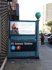
The station has a full-length mezzanine above the platforms and tracks.[12] All of the mezzanine is still completely open, with the exception of a tiny closed fenced-off section at the station's eastern end that is accessed from a single closed staircase on the Manhattan-bound platform. [29][30] However, it is set up in a way that does not allow a free transfer between directions, as the fare control is located in the middle of the mezzanine.[31] The token booth and turnstile banks for either direction are at the center.[31][32] HEET turnstiles are at either ends near the station's entrances and exits, both of which have two street stairs.[33][34] The entrance at the west (railroad south) end leads to the northwest corner[35] and southwest corners of Queens Boulevard and 75th Avenue,[36] while the one on the east (railroad north) end leads to southeast corner of Queens Boulevard and 75th Road.[37] Chain-link fences separate the sections of the mezzanine within fare control and the section out of fare control.[38] The section of the mezzanine within fare control used to span across the entire space, but a fare-free underpass under Queens Boulevard now divides the northbound and southbound parts of the mezzanine, and there is no way to make a free transfer between the two platforms anymore.[39]
Track layout
There are two diamond switches near the western end of this station, located between the local and express tracks in each direction.[40] This switch is used in revenue service. E and F trains use it to switch from the Queens Boulevard express tracks to the local tracks, allowing them to stop at 75th Avenue. The F uses these switches at all times, while the E only uses them on weekends and during weekday evenings.[41] The stretch of local track between 71st Avenue and 75th Avenue is only used in revenue service during late nights, when the E runs local.[22][42]
There are also four tracks underneath this station, which are not visible from the platforms. An emergency exit located in the middle of the Jamaica-bound platform leads to this lower level. The two outer tracks lead to Jamaica Yard while the two center tracks are used for reversing trains from Forest Hills–71st Avenue and end at bumper blocks just below Kew Gardens - Union Turnpike station under the mainline tracks. The two center tracks used for reversing trains can be seen from Jamaica bound express train. On the west end of the station, there are two punch boxes one on the local and express tracks. [40][42]:50[43]
Ridership
75th Avenue is served by the F train at all times,[24] and the E train at all times except weekday rush hours and middays (6:00 a.m.–6:00 p.m.).[23] In the 1970s, when the New York City Subway was at an all-time low, following the general trend of a decrease in ridership, the number of passengers using the 75th Avenue station decreased by 300,000 passengers.[44] The 75th Avenue station sees low ridership because it serves only local trains, and because the adjacent stations of Forest Hills and Kew Gardens are express stations and thus see more frequent service. In 2016, the station had 1,102,600 boardings, making it the 346th most used station in the 422-station system.[4] This amounted to an average of 3,710 passengers per weekday.[45]
Notes
- ↑ The subway cars on the IND were built to be 60 feet (18.3 m) long. These cars typically operated in 10-car trains, with an entire train length being 600 feet (182.9 m). When platforms at stations such as 75th Avenue were lengthened to accommodate 11-car trains, the platforms had to be extended an additional car length, or 60 feet, making the platform at least 660 feet (201.2 m) long.[18]:185
References
- ↑ "Station Developers' Information". Metropolitan Transportation Authority. Retrieved June 13, 2017.
- ↑ "NYC Subway Wireless – Active Stations". Transit Wireless Wifi. Retrieved May 18, 2016.
- ↑ More Subway Stations in Manhattan, Bronx in Line to Get Online, mta.info (March 25, 2015). "The first two phases included stations in Midtown Manhattan and all underground stations in Queens with the exception of the 7 Main St terminal."
- 1 2 "Facts and Figures: Annual Subway Ridership 2012–2017". Metropolitan Transportation Authority. July 12, 2018. Retrieved July 12, 2018.
- ↑ "NEW SUBWAY ROUTES IN HYLAN PROGRAM TO COST $186,046,000" (PDF). The New York Times. March 21, 1925. p. 1. Retrieved December 11, 2016.
- ↑ "TWO SUBWAY LINKS OPENED IN QUEENS". The New York Times. August 19, 1933. p. 13. Retrieved December 11, 2016.
- ↑ "CITY SUBWAY OPENS QUEENS LINK TODAY". The New York Times. December 31, 1936. Retrieved April 26, 2016.
- ↑ "OPENING MOVED UP FOR NEW SUBWAY". The New York Times. December 26, 1936. Retrieved April 26, 2016.
- ↑ "104 STATION SITES FOR CITY'S SUBWAYS CHOSEN BY BOARD" (PDF). The New York Times. June 2, 1930. Retrieved October 27, 2015.
- ↑ Kern-Jedrychowska, Ewa (April 16, 2015). "Streets With 2 Names Cause 'Chronic' 911 Problems, Official Says". DNAinfo.com. Archived from the original on December 19, 2015. Retrieved October 27, 2015.
- ↑ "NEW SUBWAY TO ADD 2 NEEDED SERVICES; Opening of 6th Ave. Line to Provide Uptown Local Route and More Queens Expresses". The New York Times. December 2, 1939. ISSN 0362-4331. Retrieved December 8, 2016.
- 1 2 Marks, Seymour (January 20, 1959). "Phantom Subway: Ideal Spot to Park". Long Island Star-Journal. Fultonhistory.com. p. 3. Retrieved August 12, 2016.
- ↑ "SUBWAY LINK AIDS REALTY ACTIVITY". The New York Times. March 7, 1937. ISSN 0362-4331. Retrieved April 26, 2016.
- ↑ Hirshon, Nicholas (2013). Forest Hills. Arcadia Publishing. p. 74. ISBN 978-0-7385-9785-0.
- ↑ Copquin, Claudia Gryvatz (2007). The Neighborhoods of Queens. Yale University Press. ISBN 0-300-11299-8.
- ↑ "DEMAND IS NOTED FOR QUEENS HOMES". The New York Times. July 18, 1937. ISSN 0362-4331. Retrieved April 26, 2016.
- ↑ Myers, Steven Lee (June 14, 1992). "Life Beyond the Subway Is Subject to Its Own Disruptions". The New York Times. Retrieved April 26, 2016.
- ↑ Sansone, Gene (October 25, 2004). New York Subways: An Illustrated History of New York City's Transit Cars. JHU Press. ISBN 9780801879227.
- 1 2 Ingalls, Leonard (August 28, 1953). "2 Subway Lines to Add Cars, Another to Speed Up Service" (PDF). New York Times. Retrieved January 25, 2016.
- ↑ Proceedings. New York Board of Transportation. 1951 – via Google Books.
- ↑ Report. New York City Transit Authority. 1953.
- 1 2 Dougherty, Peter (2002). "NYC Track Map Book Page 50 Queens F" (PDF). nyctrackmapbook.com. Archived from the original (PDF) on April 6, 2003. Retrieved July 3, 2016.
- 1 2 "E Subway Timetable, Effective June 24, 2018" (PDF). Metropolitan Transportation Authority. Retrieved June 24, 2018.
- 1 2 "F Subway Timetable, Effective June 24, 2018" (PDF). Metropolitan Transportation Authority. Retrieved June 24, 2018.
- ↑ Cox, Jeremiah (June 2, 2008). The 75th Ave tiled text a tile width below the lime green trim with a black border (image).
- 1 2 Cox, Jeremiah (June 2, 2008). A name tablet with a mosaic arrow for the exit to 75th Ave (image).
- ↑ Cox, Jeremiah (June 2, 2008). Looking down an empty Manhattan-bound platform at 75th Ave (image).
- ↑ NYCSubwaySystem (June 26, 2012). NYC Subway: 75 Avenue, F Train. Retrieved December 6, 2016 (The platform sign showing the name as "75 Av-Puritan Av" can be seen at the 0:09 mark of the video, and an entrance sign showing this name can be seen at the 2:18 mark)
- ↑ Cox, Jeremiah (June 2, 2008). "A view of a closed staircase up to the mezzanine at 75th Ave". subwaynut.com. Retrieved December 10, 2016.
- ↑ Cox, Jeremiah (January 3, 2012). "The closed off extreme eastern end of the mezzanine". subwaynut.com. Retrieved December 10, 2016.
- 1 2 Cox, Jeremiah (January 2, 2013). "Approaching the token booth on the middle mezzanine". subwaynut.com. Retrieved December 10, 2016.
- ↑ Cox, Jeremiah (June 2, 2008). "A view of the turnstiles in the center of the station from the Manhattan-bound side of the mezzanine, nowhere near an exit to the street". subwaynut.com. Retrieved December 10, 2016.
- ↑ Cox, Jeremiah (January 3, 2012). "Two high turnstiles to the 75 Road exit". subwaynut.com. Retrieved December 10, 2016.
- ↑ Cox, Jeremiah (June 2, 2008). "A view of the High Entrance/Exit gates to the 75 Avenue exit, this means passengers don't have to walk the equivalent of 1/2 way down a platform length to find turnstiles to enter the system". subwaynut.com. Retrieved December 10, 2016.
- ↑ Cox, Jeremiah (June 2, 2008). "A mosaic sign outside of fare control for 75th Ave/N Side Queens Blvd". subwaynut.com. Retrieved December 15, 2016.
- ↑ Cox, Jeremiah (January 3, 2012). "Mosaic for 75th Ave. and the S. Side Queens Blvd". subwaynut.com. Retrieved December 15, 2016.
- ↑ "Neighborhood Map Kew Gardens, Forest Hills, Kew Gardens Hills, Hillcrest, Briarwood, Richmond Hill" (PDF). mta.info. Metropolitan Transport`ation Authority. 2015. Retrieved July 3, 2016.
- ↑ Cox, Jeremiah (June 2, 2008). "Another view down the Manhattan-bound side of the mezzanine at 75th Avenue, the cheep-looking chain link fence painted white that separates it from the area outside of fare control is visible". subwaynut.com. Retrieved December 10, 2016.
- ↑ Cox, Jeremiah (January 3, 2012). "The Jamaica-bound platform is exit only near the exits". subwaynut.com. Retrieved December 11, 2016.
- 1 2 Dougherty, Peter (2018). Tracks of the New York City Subway 2018 (16th ed.). Dougherty.
- ↑ "Review of F Line Operations, Ridership, and Infrastructure" (PDF). mta.info. Metropolitan Transportation Authority. October 7, 2009. Retrieved December 10, 2016.
- 1 2 Dougherty, Peter (2018). Tracks of the New York City Subway 2018 (16th ed.). Dougherty.
- ↑ Linsky, Alan. "A Picture History of Kew Gardens, NY – Queens Boulevard Rapid Transit". www.oldkewgardens.com. Kew Gardens Civic Association Incorporated. Retrieved April 26, 2016.
- ↑ Burks, Edward C. (April 20, 1975). "Ridership on Queens Subways Down". The New York Times. ISSN 0362-4331. Retrieved July 3, 2016.
- ↑ "Facts and Figures: Average Weekday Subway Ridership 2012–2017". Metropolitan Transportation Authority. July 12, 2018. Retrieved July 12, 2018.
External links

- Track map of the area, from nycsubway.org
- 75th Avenue entrance from Google Maps Street View
- 75th Road entrance from Google Maps Street View
- Platforms from Google Maps Street View