63rd Drive–Rego Park (IND Queens Boulevard Line)
63 Drive–Rego Park | |||||||||||
|---|---|---|---|---|---|---|---|---|---|---|---|
|
| |||||||||||
 A platform at 63rd Drive. | |||||||||||
| Station statistics | |||||||||||
| Address |
63rd Drive & Queens Boulevard Rego Park, NY 11374 | ||||||||||
| Borough | Queens | ||||||||||
| Locale | Rego Park | ||||||||||
| Coordinates | 40°43′48″N 73°51′43″W / 40.73°N 73.862°WCoordinates: 40°43′48″N 73°51′43″W / 40.73°N 73.862°W | ||||||||||
| Division | B (IND) | ||||||||||
| Line | IND Queens Boulevard Line | ||||||||||
| Services |
E M R | ||||||||||
| Transit connections |
| ||||||||||
| Structure | Underground | ||||||||||
| Platforms | 2 side platforms | ||||||||||
| Tracks | 4 | ||||||||||
| Other information | |||||||||||
| Opened | December 31, 1936 | ||||||||||
| Station code | 263[1] | ||||||||||
| Wireless service |
| ||||||||||
| Former/other names | 63rd Drive | ||||||||||
| Traffic | |||||||||||
| Passengers (2017) |
4,991,559[4] | ||||||||||
| Rank | 98 out of 425 | ||||||||||
| Station succession | |||||||||||
| Next east |
67th Avenue: E | ||||||||||
| Next west |
Woodhaven Boulevard: E | ||||||||||
| |||||||||||
| |||||||||||
| |||||||||||


63rd Drive–Rego Park is a local station on the IND Queens Boulevard Line of the New York City Subway, consisting of four tracks. Located at 63rd Drive and Queens Boulevard in the Rego Park neighborhood of Queens, it is served by the M train on weekdays, the R train at all times except nights, and the E train at night.
History
The Queens Boulevard Line was one of the first lines built by the city-owned Independent Subway System (IND),[5][6][7] and stretches between the IND Eighth Avenue Line in Manhattan and 179th Street and Hillside Avenue in Jamaica, Queens.[5][7][8] The Queens Boulevard Line was in part financed by a Public Works Administration (PWA) loan and grant of $25,000,000.[9] On December 31, 1936, the IND Queens Boulevard Line was extended by eight stops, and 3.5 miles (5.6 km), from its previous terminus at Roosevelt Avenue to Union Turnpike, and the 63rd Drive station opened as part of this extension.[10][11][12][13][14][15]
Station layout
| G | Street level | Exit/entrance |
| M | Mezzanine | Fare control, station agent, MetroCard machines |
| P Platform level |
Side platform, doors will open on the right | |
| Southbound local | ← ← ← | |
| Southbound express | ← | |
| Northbound express | | |
| Northbound local | | |
| Side platform, doors will open on the right | ||
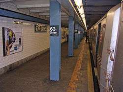
Both platforms have a medium Sky Blue trim line with a black border and small "63RD DRIVE" signs below them in white lettering on a black border. The name tablets read "63RD DRIVE" in white sans serif font on a black border and identical blue trim. Above some of these tablets are modern signs reading "Rego Park". Some of the columns separating the local and express tracks have small "63RD DRIVE" signs on them in black lettering on a white border. The station's I-beam columns are all painted Slate Blue with alternating ones on the platforms having the standard black station name plate in white lettering.
This station has an upper level mezzanine that is about 1/3rd the length of the platforms. The mezzanine is split into three sections by a wall on the southbound side and a chain link fence on the northbound side. Numerous staircases from each platform go up to their respective outer section of the mezzanine. A small turnstile bank on the southbound side and exit-only turnstiles on the northbound side lead to the main fare control area.
Exits
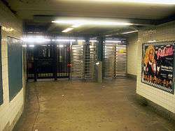
Towards the northwest end of the mezzanine, a single extra-wide staircase from each platform goes up to a crossover, where a turnstile bank leads to the main fare control area. There is a token booth and two street stairs, one to the northwest corner of 63rd Drive and Queens Boulevard and the other to the south side of Queens Boulevard near this intersection.[16]
On the southeast side of the mezzanine, high entry-exit turnstiles from either outer section lead to an un-staffed fare control area, where one street stair goes up to the northwest corner of 64th Avenue and Queens Boulevard while the other goes up to the south side of Queens Boulevard near the intersection with 64th Road. The mezzanine has mosaic directional signs in white lettering on a teal border. The center section connects the two fare control areas, but provides no crossover.[16]
On the extreme northwest (railroad south) end of the platforms, high turnstiles lead to a single staircase that goes up to either western corners of 63rd Road and Queens Boulevard, the northwest one for the Manhattan-bound platform and the southwest one for the Forest Hills-bound platform.[16]
Unfinished Rockaway spur
East of this station, there is an unfinished signal tower on the Jamaica-bound (railroad north) platform and a bellmouth that diverges to the south from the local track. Another tunnel from the Manhattan-bound local track diverges north, then curves south under the Queens Boulevard Line to join the other bellmouth.[17] These were provisions for a planned expansion in the 1930s that would have connected with the IND Rockaway Line (formerly a Long Island Rail Road branch) towards Howard Beach, JFK Airport, and the Rockaways.[18][19][20][21][22] This spur would have run down 66th Avenue before joining the Rockaway Line at its former junction with the LIRR Main Line.[20] In January 2013, a petition was started on change.org to make use of the bellmouths to connect the station to the currently unused portion of the Rockaway Line.[23]
References
- ↑ "Station Developers' Information". Metropolitan Transportation Authority. Retrieved June 13, 2017.
- ↑ "NYC Subway Wireless – Active Stations". Transit Wireless Wifi. Retrieved May 18, 2016.
- ↑ More Subway Stations in Manhattan, Bronx in Line to Get Online, mta.info (March 25, 2015). "The first two phases included stations in Midtown Manhattan and all underground stations in Queens with the exception of the 7 Main St terminal."
- ↑ "Facts and Figures: Annual Subway Ridership 2012–2017". Metropolitan Transportation Authority. July 12, 2018. Retrieved July 12, 2018.
- 1 2 Duffus, R.L. (September 22, 1929). "OUR GREAT SUBWAY NETWORK SPREADS WIDER; New Plans of Board of Transportation Involve the Building of More Than One Hundred Miles of Additional Rapid Transit Routes for New York". The New York Times. Retrieved August 19, 2015.
- ↑ "QUEENS SUBWAY WORK AHEAD OF SCHEDULE: Completion Will Lead to Big Apartrnent Building, Says William C. Speers". The New York Times. April 7, 1929. Retrieved September 1, 2015.
- 1 2 "Queens Lauded as Best Boro By Chamber Chief". Brooklyn Daily Eagle. September 23, 1929. p. 40. Retrieved October 4, 2015 – via Newspapers.com.
- ↑ "New Subway Routes in Hylan Program to Cost $186,046,000" (PDF). The New York Times. March 21, 1925. p. 1.
- ↑ "TEST TRAINS RUNNING IN QUEENS SUBWAY; Switch and Signal Equipment of New Independent Line Is Being Checked". The New York Times. December 20, 1936. ISSN 0362-4331. Retrieved April 26, 2016.
- ↑ "NEW RETAIL AREA IN QUEENS BOROUGH; Sees Roosevelt Avenue Subway Station as Great Shopping Centre. ADVANTAGES POINTED OUT Accessibility to Many Home Communities Assures Potential Market". The New York Times. July 9, 1933. ISSN 0362-4331. Retrieved April 26, 2016.
- ↑ "Reproduction Poster of Extension to Union Turnpike – Kew Gardens". Flickr – Photo Sharing!. Retrieved April 26, 2016.
- ↑ Roger P. Roess; Gene Sansone (August 23, 2012). The Wheels That Drove New York: A History of the New York City Transit System. Springer Science & Business Media. pp. 416–417. ISBN 978-3-642-30484-2.
- ↑ "PWA Party Views New Subway Link: Queens Section to Be Opened Tomorrow Is Inspected by Tuttle and Others" (PDF). The New York Times. December 30, 1936. Retrieved June 27, 2015.
- ↑ "CITY SUBWAY OPENS QUEENS LINK TODAY; Extension Brings Kew Gardens Within 36 Minutes of 42d St. on Frequent Trains". The New York Times. December 31, 1936. ISSN 0362-4331. Retrieved April 26, 2016.
- ↑ "OPENING MOVED UP FOR NEW SUBWAY; Traffic to Be Started on the Extension of City's Line to Kew Gardens on Thursday. EIGHT STATIONS ARE ADDED La Guardia and Official Party Will Inspect New Queens Branch on Wednesday". The New York Times. December 26, 1936. ISSN 0362-4331. Retrieved April 26, 2016.
- 1 2 3 "MTA Neighborhood Maps: Forest Hills" (PDF). mta.info. Metropolitan Transportation Authority. 2015. Retrieved July 6, 2015.
- ↑ "Tomb Ov The Unknown Tunnel". ltvsquad.com. Retrieved February 8, 2016.
- ↑ "The Express Stop That Never Was". ltvsquad.com. LTV Squad. June 2, 2015. Retrieved June 27, 2015.
- ↑ Kihss, Peter (April 13, 1967). "3 Routes Proposed to Aid Growing Queens Areas" (PDF). The New York Times. Retrieved June 27, 2015.
- 1 2 "City Plans to Buy New Subway Link: Would Take Over Rockaway Branch of Long Island to Connect With Queens" (PDF). The New York Times. December 23, 1933. Retrieved June 30, 2015.
- ↑ "Complete Text of TA's Queens Subway Plan". Long Island Star-Journal. Fultonhistory.com. April 1, 1963. p. 8. Retrieved April 27, 2016.
- ↑ Perlow, Austin H. (March 15, 1957). "New Rockaway Link Possible at Bargain Price". Long Island Star-Journal. Fultonhistory.com. p. 6. Retrieved August 18, 2016.
- ↑ Capt. Subway (January 21, 2013). "Guest Post: How sending the R train to Howard Beach can help the G go to Forest Hills". Cap'n Transit Rides Again Blog. Retrieved December 25, 2013.
External links
| Wikimedia Commons has media related to 63rd Drive – Rego Park (IND Queens Boulevard Line). |
- nycsubway.org – IND Queens Boulevard Line: 63rd Drive/Rego Park
- nycsubway.org – The History of the Independent Subway:
- Station Reporter — R Train
- Station Reporter — M Train
- Forgotten NY: Subways and Trains — Rockaway Branch
- Forgotten NY: Subways and Trains — Subway Signs to Nowhere
- The Subway Nut - 63rd Drive–Rego Park Pictures
- 63rd Road exit only stair from Google Maps Street View
- 63rd Drive entrance from Google Maps Street View
- 64th Road entrance from Google Maps Street View
- Platforms from Google Maps Street View