Clinton–Washington Avenues (IND Crosstown Line)
Clinton–Washington Avenues | |||||||
|---|---|---|---|---|---|---|---|
|
| |||||||
 Queens-bound platform | |||||||
| Station statistics | |||||||
| Address |
Lafayette Avenue between Clinton Avenue & Washington Avenue Brooklyn, NY 11205 | ||||||
| Borough | Brooklyn | ||||||
| Locale | Clinton Hill | ||||||
| Coordinates | 40°41′17″N 73°58′01″W / 40.688058°N 73.96687°WCoordinates: 40°41′17″N 73°58′01″W / 40.688058°N 73.96687°W | ||||||
| Division | B (IND) | ||||||
| Line | IND Crosstown Line | ||||||
| Services |
G | ||||||
| Transit connections |
| ||||||
| Structure | Underground | ||||||
| Platforms | 2 side platforms | ||||||
| Tracks | 2 | ||||||
| Other information | |||||||
| Opened | July 1, 1937[1] | ||||||
| Station code | 291[2] | ||||||
| Wireless service |
| ||||||
| Traffic | |||||||
| Passengers (2017) |
1,551,042[4] | ||||||
| Rank | 298 out of 425 | ||||||
| Station succession | |||||||
| Next north |
Classon Avenue: G | ||||||
| Next south |
Fulton Street: G | ||||||
| |||||||
| |||||||
| |||||||


Clinton–Washington Avenues is a station on the IND Crosstown Line of the New York City Subway. Located at Lafayette Avenue between Clinton and Washington Avenues in Clinton Hill, Brooklyn, it is served by the G train at all times.
History
This station opened on July 1, 1937, when the entire Crosstown Line was completed between Nassau Avenue and its connection to the IND Culver Line. On this date, the GG was extended in both directions to Smith–Ninth Streets and Forest Hills–71st Avenue.[1]
Station layout
| G | Street level | Entrances/exits |
| M | Mezzanine | To entrances/exits, station agent, MetroCard machines |
| P Platform level |
Side platform, doors will open on the right | |
| Southbound | ← | |
| Northbound | | |
| Side platform, doors will open on the right | ||
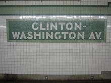
This underground station has two tracks and two side platforms.[5] Both platforms have a light green trim line with a dark green border and name tablets reading "CLINTON - WASHINGTON AV." on two lines in white sans serif lettering on a dark green background and a lighter green border. Beneath the trim line and name tablets are small directional signs and station names (alternating between "CLINTON" and "WASHINGTON") in white lettering on a black border. Yellow i-beam columns run along both platforms at regular intervals with every other one having the standard black station name plate in white lettering.
The mezzanine has five murals of artwork, each of different names and artists. They are Night and Day by Jim Porter installed in 1998, Safe Passage by Dan Simmons, an untitled artwork by Maku, Fusion by Jamal Ince installed in 2000, and Mercury by John Woodrow Kelley installed in 2000.
Exits
This station has a full length mezzanine above the platforms and tracks supported by yellow I-beam columns. The center of the mezzanine is outside fare control and has a token booth and two street stairs at each end. The ones on the west (railroad south) go up to the northeast and southwest corners of Clinton and Lafayette Avenues while the ones on the east (railroad north) end go up to either eastern corners of Washington and Lafayette Avenues.[6] The center of the mezzanine also has a bank of turnstiles, two exit-only turnstiles, and two staircases going down to each platform.[5]
At either end of the mezzanine are unstaffed entrances/exits containing two exit-only turnstiles, one high entry/exit turnstile, and one staircase to each platform. Both of these fare control areas have a crossover that allow a free transfer between directions. A short staircase is required to reach the center mezzanine from the Clinton Avenue fare control area due to a higher ceiling.[5]
Nearby points of interest
References
- 1 2 "New Crosstown Subway Line Is Opened". Brooklyn Daily Eagle. July 1, 1937. Retrieved December 24, 2015.
- ↑ "Station Developers' Information". Metropolitan Transportation Authority. Retrieved June 13, 2017.
- ↑ "NYC Subway Wireless – Active Stations". Transit Wireless Wifi. Retrieved May 18, 2016.
- ↑ "Facts and Figures: Annual Subway Ridership 2012–2017". Metropolitan Transportation Authority. July 12, 2018. Retrieved July 12, 2018.
- 1 2 3 "Review of the G Line: Appendices" (PDF). Metropolitan Transportation Authority. July 10, 2013. Retrieved October 28, 2015.
- 1 2 3 4 5 "MTA Neighborhood Maps: Bedford-Stuyvesant" (PDF). Metropolitan Transportation Authority. 2016. Retrieved July 5, 2016.
External links
| Wikimedia Commons has media related to Clinton–Washington Avenues (IND Crosstown Line). |
- nycsubway.org – IND Crosstown: Clinton–Washington Aves.
- Station Reporter — G Train
- The Subway Nut — Clinton–Washington Avenues Pictures
- Clinton Avenue entrance from Google Maps Street View
- Washington Avenue entrance from Google Maps Street View
- Platforms from Google Maps Street View
Crosstown |
|
|---|---|
| |
| Crosstown Line |
|
|---|---|
| |