65th Street (IND Queens Boulevard Line)
65 Street | |||||||||||
|---|---|---|---|---|---|---|---|---|---|---|---|
|
| |||||||||||
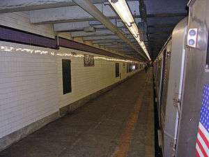 R46 R train at the station. | |||||||||||
| Station statistics | |||||||||||
| Address |
65th Street & Broadway Queens, NY 11377 | ||||||||||
| Borough | Queens | ||||||||||
| Locale | Woodside | ||||||||||
| Coordinates | 40°44′58″N 73°53′50″W / 40.7494°N 73.8973°WCoordinates: 40°44′58″N 73°53′50″W / 40.7494°N 73.8973°W | ||||||||||
| Division | B (IND) | ||||||||||
| Line | IND Queens Boulevard Line | ||||||||||
| Services |
E M R | ||||||||||
| Structure | Underground | ||||||||||
| Platforms | 2 side platforms | ||||||||||
| Tracks | 4 | ||||||||||
| Other information | |||||||||||
| Opened | August 19, 1933 | ||||||||||
| Station code | 268[1] | ||||||||||
| Wireless service |
| ||||||||||
| Traffic | |||||||||||
| Passengers (2017) |
1,120,703[4] | ||||||||||
| Rank | 339 out of 425 | ||||||||||
| Station succession | |||||||||||
| Next east |
Jackson Heights–Roosevelt Avenue: E | ||||||||||
| Next west |
Northern Boulevard: E | ||||||||||
| |||||||||||
| |||||||||||
| |||||||||||


65th Street is a local station on the IND Queens Boulevard Line of the New York City Subway, located at the intersection of 65th Street and Broadway in Queens. It is served by the M train on weekdays, the R train at all times except nights, and the E train at night.
History
The Queens Boulevard Line was one of the first lines built by the city-owned Independent Subway System (IND),[5][6][7] and stretches between the IND Eighth Avenue Line in Manhattan and 179th Street and Hillside Avenue in Jamaica, Queens.[5][7][8] The Queens Boulevard Line was in part financed by a Public Works Administration (PWA) loan and grant of $25,000,000.[9] One of the proposed stations would have been located at 65th Street.
The first section of the line, west from Roosevelt Avenue to 50th Street, opened on August 19, 1933. E trains ran local to Hudson Terminal (today's World Trade Center) in Manhattan, while the GG (predecessor to current G service) ran as a shuttle service between Queens Plaza and Nassau Avenue on the IND Crosstown Line.[10][11][12][13][14][15]
Station layout
| G | Street level | Exit/entrance |
| M | Mezzanine | Fare control, station agent, MetroCard machines |
| P Platform level |
Side platform, doors will open on the right | |
| Southbound local | ← ← ← | |
| Southbound express | ← | |
| Northbound express | | |
| Northbound local | | |
| Side platform, doors will open on the right | ||
This underground station has two side platforms and four tracks. The two center express tracks are used by the E train during daytime hours and the F train at all times.
Signs to the Forest Hills-bound platform are on the wall instead of hanging over the staircase. The reason for this was because the original 1933 IND tile sign read "Jamaica and Rockaway", anticipating construction of a never-built system expansion. These signs remained uncovered as late as 2001.[16] The 1933 Manhattan-bound tile signs remain intact.
The station's tile bands are Puce with a black border. Some violet replacement tiles have been placed.
West of this station, the express tracks become depressed and break from the local tracks. The express tracks run underneath Northern Boulevard, while the local tracks continue under Broadway and then turn to Steinway Street before meeting up with the express trains underneath Northern and Steinway. The line was built in this fashion because Broadway and Steinway Street are too narrow to align four tracks side by side underneath them.
Exits
The full-time mezzanine is at the eastern end has three staircases to each platform and two staircases to the street, one to either eastern corner of Broadway and 65th Street.[17] Both sides had fare controls and former booths at platform levels at the far western end, at the opposite end of the current mezzanine. They have since been sealed. Signs at the northeast exit as well as the Manhattan-bound platforms are for Rowan Street, the former name of 65th Street.[18][19]
References
- ↑ "Station Developers' Information". Metropolitan Transportation Authority. Retrieved June 13, 2017.
- ↑ "NYC Subway Wireless – Active Stations". Transit Wireless Wifi. Retrieved May 18, 2016.
- ↑ More Subway Stations in Manhattan, Bronx in Line to Get Online, mta.info (March 25, 2015). "The first two phases included stations in Midtown Manhattan and all underground stations in Queens with the exception of the 7 Main St terminal."
- ↑ "Facts and Figures: Annual Subway Ridership 2012–2017". Metropolitan Transportation Authority. July 12, 2018. Retrieved July 12, 2018.
- 1 2 Duffus, R.L. (September 22, 1929). "OUR GREAT SUBWAY NETWORK SPREADS WIDER; New Plans of Board of Transportation Involve the Building of More Than One Hundred Miles of Additional Rapid Transit Routes for New York". The New York Times. Retrieved August 19, 2015.
- ↑ "QUEENS SUBWAY WORK AHEAD OF SCHEDULE: Completion Will Lead to Big Apartrnent Building, Says William C. Speers". The New York Times. April 7, 1929. Retrieved September 1, 2015.
- 1 2 "Queens Lauded as Best Boro By Chamber Chief". Brooklyn Daily Eagle. September 23, 1929. p. 40. Retrieved October 4, 2015 – via Newspapers.com.
- ↑ "New Subway Routes in Hylan Program to Cost $186,046,000" (PDF). The New York Times. March 21, 1925. p. 1.
- ↑ "TEST TRAINS RUNNING IN QUEENS SUBWAY; Switch and Signal Equipment of New Independent Line Is Being Checked". The New York Times. December 20, 1936. ISSN 0362-4331. Retrieved April 26, 2016.
- ↑ Kramer, Frederick A. (1990). Building the Independent Subway. Quadrant Press. ISBN 978-0-915276-50-9.
- ↑ Raskin, Joseph B. (November 1, 2013), The Routes Not Taken: A Trip Through New York City's Unbuilt Subway System, Fordham University Press, ISBN 978-0-8232-5369-2
- ↑ "Independent Subway Services Beginning in 1932". thejoekorner.com. August 21, 2013. Retrieved August 2, 2015.
- ↑ "TWO SUBWAY UNITS OPEN AT MIDNIGHT; Links in City-Owned System in Queens and Brooklyn to Have 15 Stations" (PDF). The New York Times. August 18, 1933. Retrieved November 7, 2015.
- ↑ "New Queens Subway Service Will Be Launched Tonight; Tunnel From Manhattan Open to Jackson Heights; Service Will Eventually Be Extended Through To Jamaica". Long Island Daily Press. Fultonhistory.com. August 18, 1933. p. 20. Retrieved July 27, 2016.
- ↑ "New Queens Tube To Open Saturday: Brooklyn-Long Island City Link of City Line Also to Be Put in Operation". New York Evening Post. Fultonhistory.com. August 17, 1933. p. 18. Retrieved July 27, 2016.
- ↑ Subway Signs to Nowhere (Forgotten New York)
- ↑ "MTA Neighborhood Maps: Astoria" (PDF). Metropolitan Transportation Authority. 2015. Retrieved September 27, 2015.
- ↑ DanTD (March 16, 2017). 65th Street; Rowan Street Mosaic (photograph). Retrieved April 2, 2017.
- ↑ DanTD (March 16, 2017). 65th Street IND Queens; Rowan & B'Way Exit.jpg (photograph). Retrieved April 2, 2017.
External links
| Wikimedia Commons has media related to 65th Street (IND Queens Boulevard Line). |
- nycsubway.org – IND Queens Boulevard Line: 65th Street
- Station Reporter — R Train
- Station Reporter — M Train
- The Subway Nut — 65th Street Pictures
- 65th Street entrance from Google Maps Street View
- Platforms from Google Maps Street View