Parsons Boulevard (IND Queens Boulevard Line)
Parsons Blvd | |||||||||
|---|---|---|---|---|---|---|---|---|---|
|
| |||||||||
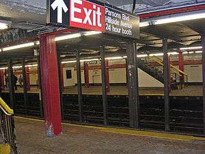 View of the Jamaica bound platform from the Manhattan bound platform. | |||||||||
| Station statistics | |||||||||
| Address |
Parsons Boulevard & Hillside Avenue Queens, NY 11432 | ||||||||
| Borough | Queens | ||||||||
| Locale | Jamaica | ||||||||
| Coordinates | 40°42′28″N 73°48′10″W / 40.70771°N 73.802762°WCoordinates: 40°42′28″N 73°48′10″W / 40.70771°N 73.802762°W | ||||||||
| Division | B (IND) | ||||||||
| Line | IND Queens Boulevard Line | ||||||||
| Services |
E F | ||||||||
| Transit connections |
| ||||||||
| Structure | Underground | ||||||||
| Platforms |
2 island platforms cross-platform interchange | ||||||||
| Tracks | 4 | ||||||||
| Other information | |||||||||
| Opened | April 24, 1937 | ||||||||
| Station code | 256[1] | ||||||||
| Wireless service |
| ||||||||
| Traffic | |||||||||
| Passengers (2017) |
1,998,650[4] | ||||||||
| Rank | 246 out of 425 | ||||||||
| Station succession | |||||||||
| Next north |
Jamaica–179th Street (express): E 169th Street (local): F | ||||||||
| Next south |
Sutphin Boulevard (local): F Kew Gardens–Union Turnpike (express): E | ||||||||
| |||||||||
| |||||||||
| |||||||||


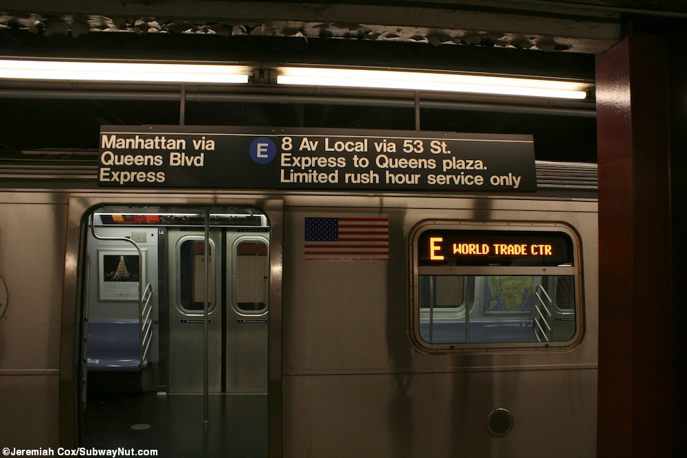
Parsons Boulevard is an express station on the IND Queens Boulevard Line of the New York City Subway. Located at the intersection of Parsons Boulevard and Hillside Avenue in Queens,[5] it is served by F service at all times. Limited rush hour E service also stops here due to capacity constraints at its primary terminal of Jamaica Center–Parsons/Archer, which is four blocks to the south of here.
History
This underground station, opened on April 24, 1937, when the Independent Subway System's Queens Boulevard Line was extended from Kew Gardens–Union Turnpike to a new terminal station at 169th Street.[6][7][8] While 169th Street was the end of the line, F trains terminated here because the 169th Street station provided an unsatisfactory terminal setup for a four track line with no storage facilities provided at the station. Therefore, the line was planned to be extended to 184th Place with a station at 179th Street with two island platforms, sufficient entrances and exits, and storage for four ten-car trains. The facilities would allow for the operation of express and local service to the station.[9] The extension was completed later than expected and opened on December 11, 1950. This extension was delayed due to the Great Depression and World War II. Both E and F trains were extended to the new station.[10][11][12]
Under the 2015–2019 MTA Capital Plan, the station, along with thirty other New York City Subway stations, will undergo a complete overhaul and will be entirely closed for up to 6 months. Updates will include cellular service, Wi-Fi, charging stations, improved signage, and improved station lighting.[13][14] However, these renovations are being deferred until the 2020–2024 Capital Program due to a lack of funding.[15]
Station layout
| G | Street Level | Exit/Entrance |
| M | Mezzanine | Fare control, station agent, MetroCard vending machines |
| P Platform level |
Southbound local | ← |
| Island platform, doors will open on the left, right | ||
| Southbound express | ← | |
| Northbound express | → | |
| Island platform, doors will open on the left, right | ||
| Northbound local | → | |
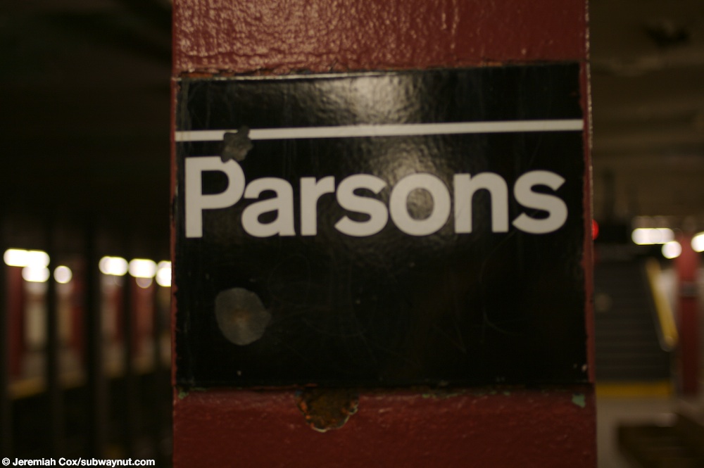
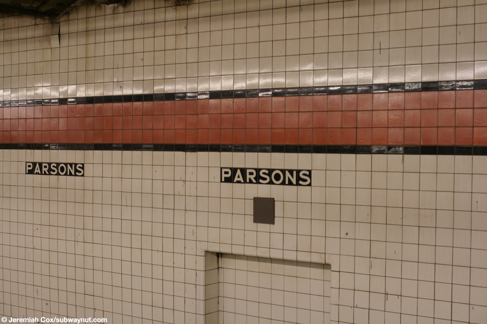
This underground station has four tracks and two island platforms. F trains stop on the outer local tracks at all times[16] while infrequent rush hour E trains stop on the center express ones.[17][18] The platform and mezzanine columns are I-beams painted maroon-red and the wall tiles along the tracks have an orange trim-line with a black border and name tiles underneath them consisting of "PARSONS" in white lettering on a black background.[19][20]
Above the platforms is a full-length mezzanine that connects the two station entrances at either ends. It has more staircases to the Jamaica-bound platform than the Manhattan-bound one due to a crew office built on the Manhattan-bound side. A pump station for draining water after floods is located at the geographical west end of the station at 153rd Street.[21]:27
Exits

The full-time entrance is at the north end of the station. It has a turnstile bank and token booth, with two street stairs leading to either southern corner of Parsons Boulevard and Hillside Avenue, and a single staircase to the northwest corner.[5]
The entrance at the south end is unstaffed, containing HEET turnstiles and three street stairs to the intersection of 153rd Street and Hillside Avenue–one each at the northern, southwest, and southeast corners of the intersection.[5] Its booth was removed in 2003.
References
- ↑ "Station Developers' Information". Metropolitan Transportation Authority. Retrieved June 13, 2017.
- ↑ "NYC Subway Wireless – Active Stations". Transit Wireless Wifi. Retrieved May 18, 2016.
- ↑ More Subway Stations in Manhattan, Bronx in Line to Get Online, mta.info (March 25, 2015). "The first two phases included stations in Midtown Manhattan and all underground stations in Queens with the exception of the 7 Main St terminal."
- ↑ "Facts and Figures: Annual Subway Ridership 2012–2017". Metropolitan Transportation Authority. July 12, 2018. Retrieved July 12, 2018.
- 1 2 3 "MTA Neighborhood Maps: Jamaica" (PDF). mta.info. Metropolitan Transportation Authority. 2015. Retrieved June 30, 2015.
- ↑ Roger P. Roess; Gene Sansone (August 23, 2012). The Wheels That Drove New York: A History of the New York City Transit System. Springer Science & Business Media. pp. 416–417. ISBN 978-3-642-30484-2.
- ↑ Kramer, Frederick A. (1990). Building the Independent Subway. Quadrant Press. ISBN 978-0-915276-50-9.
- ↑
- "Subway Link Opens Soon: City Line to Jamaica Will Start About April 24" (PDF). nytimes.com. The New York Times. March 17, 1937. Retrieved June 27, 2015.
- "Trial Run to Jamaica on Subway Tomorrow: Section From Kew Gardens to 169th Street Will Open to Public in Two Weeks" (PDF). nytimes.com. The New York Times. April 9, 1937. Retrieved June 30, 2015.
- ↑ Report including analysis of operations of the New York City transit system for five years, ended June 30, 1945. New York City: Board of Transportation of the City of New York. 1945.
- ↑ "Subway Link Opens Monday" (PDF). nytimes.com. The New York Times. December 6, 1950. Retrieved June 30, 2015.
- ↑ "Independent Subway Services Beginning in 1932". thejoekorner.com. August 21, 2013. Retrieved August 2, 2015.
- ↑
- "New Subway Link Opening in Queens" (PDF). nytimes.com. The New York Times. December 12, 1950. Retrieved June 30, 2015.
- "Subway Extension In Queens Is Voted" (PDF). nytimes.com. The New York Times. August 2, 1946. Retrieved June 30, 2015.
- ↑ "MTA Will Completely Close 30 Subway Stations For Months-Long "Revamp"". Gothamist. Archived from the original on August 1, 2016. Retrieved July 18, 2016.
- ↑ "MTAStations" (PDF). governor.ny.gov. Government of the State of New York. Retrieved July 18, 2016.
- ↑ Berger, Paul (2018-04-03). "New York Subway Cuts Back Plans to Renovate Stations". Wall Street Journal. ISSN 0099-9660. Retrieved 2018-04-03.
- ↑ "F Subway Timetable, Effective June 24, 2018" (PDF). Metropolitan Transportation Authority. Retrieved June 24, 2018.
- ↑ "E Subway Timetable, Effective June 24, 2018" (PDF). Metropolitan Transportation Authority. Retrieved June 24, 2018.
- ↑ Cox, Jeremiah (January 3, 2012). "A limited rush hour service E train stopped on the express track beneath its sign". subwaynut.com. Retrieved August 15, 2017.
- ↑ Cox, Jeremiah (June 2, 2008). "A close up of the 'parsons' text on a column at Parsons Blvd". subwaynut.com. Retrieved August 15, 2017.
- ↑ Cox, Jeremiah (June 2, 2008). "The orange wall trim that's three tiles wide and the 1/2 tile black border with Parsons letting one full tile below it along the local track walls at Parsons Blvd". subwaynut.com. Retrieved August 15, 2017.
- ↑ "August 8, 2007 Storm Report" (PDF). Metropolitan Transportation Authority. September 20, 2007. Archived from the original (PDF) on October 29, 2007. Retrieved October 27, 2007.
External links
| Wikimedia Commons has media related to Parsons Boulevard (IND Queens Boulevard Line). |
- nycsubway.org – IND Queens Boulevard Line: Parsons Boulevard (179th Street Branch)
- Station Reporter — F Train
- The Subway Nut — Parsons Boulevard Pictures
- Parsons Boulevard entrance from Google Maps Street View
- 153rd Street entrance from Google Maps Street View
- Platforms from Google Maps Street View