Fulton Street (IND Crosstown Line)
Fulton Street | |||||||
|---|---|---|---|---|---|---|---|
|
| |||||||
 Northbound platform | |||||||
| Station statistics | |||||||
| Address |
Fulton Street & Lafayette Avenue Fort Greene, NY 11217 | ||||||
| Borough | Brooklyn | ||||||
| Locale | Fort Greene | ||||||
| Coordinates | 40°41′13″N 73°58′35″W / 40.686984°N 73.976269°WCoordinates: 40°41′13″N 73°58′35″W / 40.686984°N 73.976269°W | ||||||
| Division | B (IND) | ||||||
| Line | IND Crosstown Line | ||||||
| Services |
G | ||||||
| Transit connections |
| ||||||
| Structure | Underground | ||||||
| Platforms | 2 side platforms | ||||||
| Tracks | 2 | ||||||
| Other information | |||||||
| Opened | July 1, 1937[1] | ||||||
| Station code | 292[2] | ||||||
| Wireless service |
| ||||||
| Traffic | |||||||
| Passengers (2017) |
1,698,778[4] | ||||||
| Rank | 279 out of 425 | ||||||
| Station succession | |||||||
| Next north |
Clinton–Washington Avenues: G | ||||||
| Next south |
Hoyt–Schermerhorn Streets: G | ||||||
| |||||||
| |||||||
| |||||||


Fulton Street is a station on the IND Crosstown Line of the New York City Subway, located on Lafayette Avenue between South Portland Avenue and Fulton Street in Brooklyn. It is served by the G train at all times.
History
This station opened on July 1, 1937, when the entire Crosstown Line was completed between Nassau Avenue and its connection to the IND Culver Line. On this date, the GG was extended in both directions to Smith–Ninth Streets and Forest Hills–71st Avenue.[1]
Station layout
| G | Street level | Entrances/exits |
| M | Mezzanine | To entrances/exits, station agent, MetroCard machines |
| P Platform level |
Side platform, doors will open on the right | |
| Southbound | ← | |
| Northbound | | |
| Side platform, doors will open on the right | ||
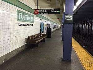
This underground station has two tracks and two side platforms.[5] Both platforms have a lime green trim line on a darker green border and name tablets reading "FULTON ST" in white sans serif font on a dark green background and lime green border. Small black "FULTON" signs in white lettering run along the trim line at regular intervals and directional signs in the same style are below the name tablets. Blue i-beam columns run along both platforms at regular intervals with alternating ones having the standard black station name plate in white lettering.
The station is very close to the Crosstown Line's junction with the IND Fulton Street Line just west of Lafayette Avenue, although the two stations do not have an in-system transfer. Riders on Manhattan-bound A and C trains can catch a glimpse of this station's platforms through the right-side windows a few seconds after leaving Lafayette Avenue. There is an employee-only connection between the two stations via the tunnels.
A proposed transfer to the busy Atlantic Avenue–Barclays Center complex was rejected by the MTA due to the long walking distance between the two stations.[6][7]
Exits
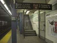
This station has a full length mezzanine above the platforms and tracks. However, most of it has been converted to employee-use only and the staircases leading up to it from the platforms are sealed off.[5] At the extreme north (geographical east) end of the station, a single staircase from each platform goes up to a single full height turnstile before a staircase goes up to either western corners of South Portland and Lafayette Avenues, the northwest one for the Queens-bound platform and the southwest one for the Church Avenue-bound platform.[5][8] These exits were closed in the mid-1980s due to concerns over maintenance expense and potential crime, but was reopened in July 2005 following community pressure.[9]
The station's full-time fare control area is at the extreme south (geographical west) end of the Church Avenue-bound platform. A bank of turnstiles at platform level leads to a token booth and one staircase going up to the northeast corner of Lafayette Avenue and Fulton Street. A crossunder here connects to the Queens-bound platform.[5]
Nearby points of interest
References
- 1 2 "New Crosstown Subway Line Is Opened". Brooklyn Daily Eagle. July 1, 1937. Retrieved December 24, 2015.
- ↑ "Station Developers' Information". Metropolitan Transportation Authority. Retrieved June 13, 2017.
- ↑ "NYC Subway Wireless – Active Stations". Transit Wireless Wifi. Retrieved May 18, 2016.
- ↑ "Facts and Figures: Annual Subway Ridership 2012–2017". Metropolitan Transportation Authority. July 12, 2018. Retrieved July 12, 2018.
- 1 2 3 4 "Review of the G Line: Appendices" (PDF). Metropolitan Transportation Authority. July 10, 2013. Retrieved October 28, 2015.
- ↑ "Review of the G Line" (PDF). mta.info. Metropolitan Transportation Authority. July 10, 2013. Retrieved August 2, 2015.
- ↑ Hoffman, Meredith (December 31, 2012). "G Train Riders to Renew Push for Improved Service With New Year". Williamsburg, Brooklyn: DNAinfo.com. Archived from the original on August 29, 2016. Retrieved August 24, 2015.
- 1 2 3 4 5 6 7 8 "MTA Neighborhood Maps: Downtown Brooklyn & Borough Hall" (PDF). Metropolitan Transportation Authority. 2016. Retrieved July 5, 2016.
- ↑ Mooney, Jake (July 3, 2005). "For a Maligned Line, a Minor Victory". The New York Times. Retrieved September 20, 2017.
External links
| Wikimedia Commons has media related to Fulton Street (IND Crosstown Line). |
- nycsubway.org – IND Crosstown: Fulton Street
- Station Reporter — G Train
- The Subway Nut — Fulton Street Pictures
- Fulton Street entrance from Google Maps Street View
- South Portland Avenue entrance from Google Maps Street View
- Platforms from Google Maps Street View
Crosstown |
|
|---|---|
| |
| Crosstown Line |
|
|---|---|
| |