Everett, Massachusetts
| Everett, Massachusetts | |||
|---|---|---|---|
| City | |||
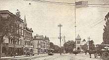
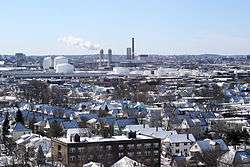 Everett in winter as viewed from the Whidden Hospital in 2007. | |||
| |||
| Motto(s): "City of Pride, Progress, and Possibilities"[1] | |||
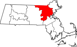
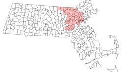 Location in Middlesex County in Massachusetts | |||
 Everett, Massachusetts Location in the United States | |||
| Coordinates: 42°24′30″N 71°03′15″W / 42.40833°N 71.05417°WCoordinates: 42°24′30″N 71°03′15″W / 42.40833°N 71.05417°W | |||
| Country | United States | ||
| State | Massachusetts | ||
| County | Middlesex | ||
| Settled | 1630 | ||
| Incorporated | 1870 | ||
| City | 1892 | ||
| Government | |||
| • Type | Mayor-council city | ||
| • Mayor | Carlo DeMaria, Jr. | ||
| Area | |||
| • Total | 3.7 sq mi (9.5 km2) | ||
| • Land | 3.4 sq mi (8.8 km2) | ||
| • Water | 0.3 sq mi (0.7 km2) | ||
| Elevation | 10 ft (3 m) | ||
| Population (2010) | |||
| • Total | 41,667 | ||
| • Estimate (2016)[2] | 46,340 | ||
| • Density | 11,000/sq mi (4,400/km2) | ||
| Time zone | UTC−5 (Eastern) | ||
| • Summer (DST) | UTC−4 (Eastern) | ||
| ZIP code | 02149 | ||
| Area code(s) | 617 / 857 | ||
| FIPS code | 25-21990 | ||
| GNIS feature ID | 0612739 | ||
| Website |
cityofeverett | ||
Everett is a city in Middlesex County, Massachusetts, United States, 4 miles (6.4 km) north of Boston. The population was 41,668 at the time of the 2010 United States Census.
Everett was the last city in the United States to have a bicameral legislature,[3] which was composed of a seven-member Board of Aldermen and an eighteen-member Common Council. On November 8, 2011, the voters approved a new City Charter that will change the City Council to a unicameral body with eleven members – six ward councilors and five councilors-at-large; an event that provoked an emotional response from many Everett residents. The new City Council was elected during the 2013 City Election.
History
Everett was originally part of Charlestown, and later Malden. It separated from Malden in 1870.[4] In 1892, Everett changed from a town to a city. On December 13, 1892, Alonzo H. Evans defeated George E. Smith to become Everett's first Mayor.[5]
The city was named after Edward Everett,[6] who served as U.S. Representative, U.S. Senator, the 15th Governor of Massachusetts, Minister to Great Britain, and United States Secretary of State. He also served as President of Harvard University.[7]
In 1971, Distrigas of Massachusetts begins importing liquefied natural gas (LNG) at its Everett Marine Terminal in the Island End section of Everett.[8] This terminal was the first of its kind in the country.[9]
Everett's business district is focused on Broadway, with many businesses and restaurants long the route. Everett Square is a small bus-hub with bus routes 104, 109, 110, 112 and 97, all served by MBTA. The Everett City Hall, Everett Fire Department, Parlin Memorial Library, and a few health centers, businesses and restaurants are centered around Everett Square on Broadway, Norwood St and Chelsea St. Everett Stadium is also near the Square. Route 16 is just south of the Square, allowing quick access to a major highway. Besides Everett Square, Gateway Center just off Route 16 in Everett is a major retail-shopping district, with big stores like Target, The Home Depot, Costco and many more. The Wynn Casino and Resort of Boston in Everett construction is expected to be underway or complete by 2020.
Everett has an increasing population as people are seeking new households near Boston while not having to pay the prices of living in Boston, Cambridge, or Somerville.
Geography
Everett is bordered by Malden on the north, Revere on the east, Chelsea on the southeast, Somerville and Medford on the west, Boston and the Mystic River on the south. Everett is a major part of the Port of Boston.
Some of Everett's neighborhoods are Glendale, Woodlawn, the Village, and the Line. Glendale Park is the city's largest park.
According to the United States Census Bureau, the city has a total area of 3.7 square miles (9.6 km2), of which 3.4 square miles (8.8 km2) is land and 0.3 square miles (0.78 km2) (7.63%) is water.
Demographics
| Historical population | ||
|---|---|---|
| Year | Pop. | ±% |
| 1870 | 2,220 | — |
| 1880 | 4,159 | +87.3% |
| 1890 | 11,068 | +166.1% |
| 1900 | 24,336 | +119.9% |
| 1910 | 33,484 | +37.6% |
| 1920 | 40,120 | +19.8% |
| 1930 | 48,424 | +20.7% |
| 1940 | 46,784 | −3.4% |
| 1950 | 45,982 | −1.7% |
| 1960 | 43,544 | −5.3% |
| 1970 | 42,485 | −2.4% |
| 1980 | 37,195 | −12.5% |
| 1990 | 35,701 | −4.0% |
| 2000 | 38,037 | +6.5% |
| 2010 | 41,667 | +9.5% |
| 2016 | 46,340 | +11.2% |
| * = population estimate. Source: United States Census records and Population Estimates Program data.[10][11][12][13][14][15][16][17] Source: | ||
As of the 2010 United States Census, there were 41,667 people, 15,435 households, and 9,554 families residing in the city. The population density was 11,241.1 people per square mile (4,345.0/km²). There were 15,908 housing units at an average density of 4,701.3 per square mile (1,817.2/km²). The racial makeup of the city was 53.6% Non-Hispanic Whites, 14.3% African American, 4.8% Asian, 0.4% Pacific Islander, 2% from other races, and 3.8% were multiracial. Hispanic or Latino of any race were 21.1% of the population (9.3% Salvadoran, 3.0% Puerto Rican, 1.1% Colombian, 1.1% Dominican, 1.0% Guatemalan, 0.8% Mexican).[19] The city also has a large number of people of Brazilian and Italian descent.[20]
There were 15,435 households out of which 27.6% had children under the age of 18 living with them, 41.8% were married couples living together, 15.2% had a female householder with no husband present, and 38.1% were non-families. 31.3% of all households were made up of individuals, and 11.8% had someone living alone who was 65 years of age or older. The average household size was 2.45 and the average family size was 3.11.
The population was spread out with 21.6% under the age of 18, 8.9% from 18 to 24, 34.8% from 25 to 44, 19.9% from 45 to 64, and 14.7% who were 65 years of age or older. The median age was 36 years. For every 100 females, there were 91 males. For every 100 females age 18 and over, there were 87.4 males.
The median income for a household in the city was $49,737. The median income for a family is $49,876. Males had a median income of $36,047 versus $30,764 for females. The per capita income for the city was $23,876. About 9.2% of families and 11.9% of the population were below the poverty line, including 16.9% of those under age 18 and 10.0% of those age 65 or over.
Foreign-born residents
In 2010, 33% of the residents of Everett were born outside the United States. This percentage was around 11% in 1990.[21]
Government
Government type
Everett has a mayor-council form of government, where the mayor serves a four-year term. The Everett city council was the last existing bicameral legislature in any American city, consisting of a Board of Aldermen and a Common Council. As of November 8, 2011, it became a unicameral City Council.
- Board of Aldermen
The Board of Aldermen consisted of seven members one from each of the City's six wards and one Alderman-at-Large. All Aldermen were elected citywide for a term of two years.
In addition to the duties they shared with the Common Council, the Board of Aldermen was the licensing authority in the City and approved licenses for motor dealers, second-hand dealers, awnings, lodging houses, junk dealers, pool tables, open-air parking lots, coin-operated devices, Lord's Day licenses, antique and precious metal dealers.
- Common Council
The Common Council consisted of three members elected per ward for a total of eighteen members. The Common Council shared equal responsibility for most legislative actions with the exception of licensing and confirmation of most Mayoral appointees.
Voter party enrollment
| Voter registration and party enrollment as of October 15, 2008[22] | |||||
|---|---|---|---|---|---|
| Party | Number of Voters | Percentage | |||
| Democratic | 9,970 | 52.02% | |||
| Republican | 975 | 5.09% | |||
| Unaffiliated | 8,099 | 42.25% | |||
| Minor Parties | 123 | 0.64% | |||
| Total | 19,167 | 100% | |||
Education
Everett has eight public schools, which include six elementary schools, five K-8 schools, and one high school, Everett High School. The city also has one Private K-8 school and one high school, Pope John XXIII High School. Everett High School moved to its new location, at 100 Elm Street, beginning in the 2007–2008 school year.
Sites of interest
Part of the historic Revere Beach Parkway listed on the National Register of Historic Places, lies in Everett.
Industries
The Mystic Generating Station has been producing electricity since the early twentieth century. It was built by Boston Edison and is now operated by Exelon. It has the largest capacity of any electrical plant in the state.
The Leavitt Corporation has been manufacturing its trademark Teddie Peanut Butter in the city since 1924.
On September 16, 2014, the Massachusetts Gaming Commission voted to approve Wynn Resorts’ proposal for a $1.6 billion casino to be located in Everett. [23]
Notable people
See also Category:People from Everett, Massachusetts
_map.jpg)
- Barbara Bishop – Director of Women Marines
- Belden Bly – member of the Massachusetts House of Representatives
- Matt Bullock – pioneering football coach, attorney
- Vannevar Bush – engineer and head of the United States Office of Scientific Research and Development
- Walter Tenney Carleton – founding director of the NEC Corporation
- Walter Carrington – US Ambassador to Nigeria & Senegal
- Benjamin Castleman – pathologist and namesake of Castleman's disease
- Patricia Courtney – All-American Girls Professional Baseball League player
- MacIntyre Dixon, actor
- Arthur Dearborn – Olympic track and field athlete
- Johnny Dell Isola – former National Football League player
- Louis DeLuca – member of the Connecticut Senate
- Maddy English – All-American Girls Professional Baseball League player
- Diamond Ferri – CFL & NFL player
- Hub Hart – MLB catcher
- Pat Hughes – NFL player
- George Keverian – Speaker of the Massachusetts House of Representatives
- Bobby King – boxer
- Richie Lamontagne – cruiserweight boxing champion, actor, model
- Torbert Macdonald – member of the United States House of Representatives
- Hermon Atkins MacNeil – sculptor
- Mary Eliza Mahoney - first African American to study and work as a professionally trained nurse in the United States (not from Everett but is buried there).
- A. David Mazzone – judge and attorney
- George J. Mead – aircraft engineer
- Gertrude Nason – artist
- Nerlens Noel – Dallas Mavericks center
- Andrew "Swede" Oberlander – College Football Hall of Famer
- Al Pierotti – football, baseball, pro wrestling
- Dan Ross – NFL player
- Ellen Pompeo – actress
- George Russell Callender, military official and author
- Paul L. Smith – actor
- Joseph Frank Wehner – fighter pilot during World War I
In popular culture
- Everett was home to the set of the 2012 ABC series Boston's Finest.
- The 2007 Ben Affleck film Gone Baby Gone was partially filmed and set in Everett.
- The old Everett High School was used for the filming of scenes for the Adam Sandler movie That's My Boy, the Kevin James movie Here Comes the Boom, and most recently Ghostbusters (2016 film) starring Melissa McCarthy, Kristen Wiig, Kate McKinnon, and Leslie Jones.
References
- ↑ "City of Everett Massachusetts". City of Everett. Retrieved October 4, 2012.
- ↑ "Population and Housing Unit Estimates". Retrieved June 9, 2017.
- ↑ "City of Everett City Council". City of Everett. Archived from the original on 2013-08-26. Retrieved 2013-07-16.
- ↑ Hogan, Julia Rich. "Town of Everett / 1870–1892" (PDF). Archived from the original (PDF) on March 1, 2012. Retrieved September 21, 2012.
- ↑ "City of Everett / 1892–1970" (PDF). Archived from the original (PDF) on March 1, 2012. Retrieved September 21, 2012.
- ↑ Gannett, Henry (1905). The Origin of Certain Place Names in the United States. Govt. Print. Off. p. 122.
- ↑ "Profile for Everett, Massachusetts". ePodunk. Retrieved 2010-05-16.
- ↑ "Distrigas". Everett Chamber of Commerce. Retrieved 14 June 2016.
- ↑ Gellerman, Bruce (March 11, 2015). "Old System, New Solution?: Liquefied Natural Gas Could Be Pipeline Alternative". WBUR. Retrieved 14 June 2016.
- ↑ "TOTAL POPULATION (P1), 2010 Census Summary File 1, All County Subdivisions within Massachusetts". United States Census Bureau. Retrieved September 13, 2011.
- ↑ "Massachusetts by Place and County Subdivision – GCT-T1. Population Estimates". United States Census Bureau. Archived from the original on November 3, 2011. Retrieved July 12, 2011.
- ↑ "1990 Census of Population, General Population Characteristics: Massachusetts" (PDF). US Census Bureau. December 1990. Table 76: General Characteristics of Persons, Households, and Families: 1990. 1990 CP-1-23. Archived from the original (PDF) on 2003-03-13. Retrieved July 12, 2011.
- ↑ "1980 Census of the Population, Number of Inhabitants: Massachusetts" (PDF). US Census Bureau. December 1981. Table 4. Populations of County Subdivisions: 1960 to 1980. PC80-1-A23. Retrieved July 12, 2011.
- ↑ "1950 Census of Population (Volume 1)" (PDF). Bureau of the Census. 1952. Section 6, Pages 21–10 and 21-11, Massachusetts Table 6. Population of Counties by Minor Civil Divisions: 1930 to 1950. Retrieved July 12, 2011.
- ↑ "1920 Census of Population" (PDF). Bureau of the Census. Number of Inhabitants, by Counties and Minor Civil Divisions. Pages 21–5 through 21-7. Massachusetts Table 2. Population of Counties by Minor Civil Divisions: 1920, 1910, and 1920. Retrieved July 12, 2011.
- ↑ "1890 Census of the Population" (PDF). Department of the Interior, Census Office. Pages 179 through 182. Massachusetts Table 5. Population of States and Territories by Minor Civil Divisions: 1880 and 1890. Retrieved July 12, 2011.
- ↑ "1870 Census of the Population" (PDF). Department of the Interior, Census Office. 1872. Pages 217 through 220. Table IX. Population of Minor Civil Divisions, &c. Massachusetts. Retrieved July 12, 2011.
- ↑ "Census of Population and Housing". Census.gov. Archived from the original on May 12, 2015. Retrieved June 4, 2015.
- ↑ "American FactFinder – Results ". Archived from the original on 18 December 2014. Retrieved 20 September 2014.
- ↑ "Everett (city) QuickFacts". United States Census Bureau. Retrieved 2013-07-16.
- ↑ Sacchetti, Maria. "A melting pot stretches out to the suburbs." Boston Globe. September 15, 2010. p. 1 (Archive). Retrieved on September 23, 2014.
- ↑ "2008 State Party Election Party Enrollment Statistics" (PDF). Massachusetts Elections Division. Retrieved 2010-07-07.
- ↑ WBUR News & Wire Services (16 September 2014). "Panel Picks Wynn's Everett Casino Proposal". WBUR. Retrieved 20 September 2014.
Further reading
- 1871 Atlas of Massachusetts. by Wall & Gray. Map of Massachusetts. Map of Middlesex County.
- Dutton, E.P. Chart of Boston Harbor and Massachusetts Bay with Map of Adjacent Country. Published 1867. A good map of roads and rail lines around Everett/South Malden.
- Old USGS maps of Everett.
- History of Middlesex County, Massachusetts, Volume 1 (A-H), Volume 2 (L-W) compiled by Samuel Adams Drake, published 1879–1880. 572 and 505 pages. Everett article by Dudley P. Bailey in volume 1 pages 428–435.
- The History of Malden, Massachusetts, 1633–1785. By Deloraine Pendre Corey, published 1898, 870 pages. Note, Everett was originally South Malden.
- Births, marriages onin Everett Mass 4 Everett deaths and Deaths in the Town of en49DelorPendre Corey, published 1903.
External links
| Wikimedia Commons has media related to Everett, Massachusetts. |