Charlotte Harbor (estuary)
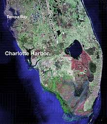
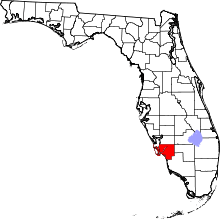
Charlotte Harbor Estuary, the second largest bay in Florida, is located on the Gulf of Mexico coast of west Florida, mostly (2/3) in Charlotte County, Florida with the remaining 1/3 in Lee County. The harbor's mouth is located behind Gasparilla Island, one of the many coastal barrier islands on the southwest coast of Florida, with access from the Gulf of Mexico through the Boca Grande Pass between Gasparilla Island on the north and Lacosta Island on the south. Charlotte Harbor covers about 270 sq mi (700 km2)
Charlotte Harbor Estuary is a natural estuary spanning the west coast of Florida from Venice to Bonita Springs on the Gulf of Mexico and is one of the most productive wetlands in Florida.[1] The estuary has a large watershed, and includes Charlotte Harbor itself as well as the Peace River, Caloosahatchee River (via Pine Island Sound) and Myakka River basins. It covers 12,653 square kilometers (4,885 sq mi), the second largest open water estuary in the state. [2]
It is classified as a bar-built estuary, formed when sandbars build up along the coastline. The sand bars block the waters behind them from the sea. Such estuaries tend to be shallow with minimal tidal action.[3]
This is a threatened ecosystem because of the rapid increase of growth and development, poor land-use policies, and the overuse of natural resources.[4] The Charlotte Harbor Aquatic Preserves, established by the state of Florida in 1975, are five contiguous aquatic preserves within the greater Charlotte Harbor estuary. It includes salt marshes, mangroves, seagrass, oyster and tidal flats.[5] It is the preserve of many species, including the American alligator, West Indian manatee, bald eagle, wood stork, piping plover, green and loggerhead sea turtles, smalltooth sawfish (Pristis pectinata)[6], royal false pawpaw (Deeringothamnus pulchellus), Florida perforate cladonia (Cladonia perforata), and many more.[2]
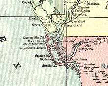
The harbor is fed with fresh water from the Myakka River on its northwest corner and the Peace River on its northeastern corner. Charlotte Harbor is bordered by the communities of Boca Grande, Port Charlotte, Charlotte Harbor, Punta Gorda and Bokeelia. Charlotte Harbor connects to San Carlos Bay to the south by way of Pine Island Sound and Matlacha Pass.
Etymology
The name of Charlotte Harbor is a corruption of the name Calusa into the Spanish name Carlos. The bay was first known as Bahia Carlos, or Carlos Bay, by the Spaniards. The English changed it from Carlos to Charlotte in honor of King George III's wife.[7]
History

Prior to the first Europeans, Charlotte Harbor was home to settlements of Native Americans who were part of the Calusa paramount chiefdom that occupied southwest Florida, extending from Tampa Bay in the north to the Ten Thousand Islands.[8] The Calusa capital of Calos was located on Mound Key, just south of Charlotte Harbor.
Early European Visits
Ponce de Leon was likely the first European who visited Charlotte Harbor in 1513 and again in 1521. He and his soldiers encountered hostile Calusa, and de Leon is believed to have died from a poisoned arrow wound received there. The site of the conflict is now Ponce de Leon Historical Park in eastern Punta Gorda.[9] Charlotte Harbor might have been next visited by Juan de Anasco, Comptroller to the King of Spain, in 1538, one year before Hernando de Soto's exploration. In 1539, Hernando de Soto began his journey across the Southeast by landing on the west coast of the Florida peninsula, near the chiefdom of Uzita, where he encountered Juan Ortiz, a survivor of the Narváez expedition who had been captured by the Tocobaga at Tampa Bay. Traditional reconstructions locate Uzita at the mouth of the Manatee River in Tampa Bay, now the site of the De Soto National Memorial.[10] However, other historians believe de Soto may have entered via Charlotte Harbor as he began his exploration of North America.[11][12] Another suggested landing site for de Soto was directly below Charlotte Harbor up within the Caloosahatchee River.[13] This is unlikely because Mound Key at the mouth of the Caloosahatchee is generally agreed to have been the location of the Calusa capital, not the Uzita chiefdom. In 1565 Pedro Menedez de Aviles, the founder of St. Augustine, established the San Antonio mission-fort at an unidentified location inside Charlotte Harbor (probably on the peace river). This catholic mission was built to be the wedding site of the chiefs daughter whose Indian name was changed to Donna Antonia and Aviles after 2 years of off-and-on fighting with the local natives, the mission was abandoned.[14]
The pirates and shipwrecks of Charlotte Harbor
The mythical José Gaspar (also known an "Gasparilla") was said to have his secret base (sometimes extravagantly referred to as a "pirate kingdom") in Charlotte Harbor from the late 1700s until his death in battle with the US Navy in 1821. Though no archival or physical evidence of Gaspar's existence has ever been found, he is a popular figure in Florida folklore, and the tale of the dashing pirate and his lost treasure has been used to promote tourism in the Charlotte Harbor for many years. The practice began in 1900, when the Charlotte Harbor and Northern Railroad Company published the first written account of Jose Gaspar in a promotional brochure for its Boca Grande Hotel.[15][16]
Charlotte Harbor is also said to have been the refuge of the pirate Brewster Baker and the site of several shipwrecks of vessels containing untold millions of Spanish gold.[17] However, no treasure-laden wrecks have been found in the area.[16]
Modern day
The Charlotte Harbor of the present day is a harbor mainly for privately owned pleasure craft and fishing boats. The area thrives partly due to tourism for those seeking beautiful beaches and an escape from winter's bite. There are also numerous retirement communities in the Charlotte Harbor area.
Hurricanes
Charlotte Harbor has been hit by hurricanes since records began to be kept in 1851. Listed below are the hurricanes whose paths have crossed Charlotte Harbor.[18]
- 1894 Hurricane No. 4, (09/18 - 10/01) Category 2 total number of deaths (over its entire path) = 200
- 1910 Hurricane No. 5, (10/09 - 10/23) Category 2 total number of deaths (over its entire path) = 101
- 1925 Hurricane No. 2, (11/29 - 12/04) Category 1, total number of deaths (over its entire path) = 60
- 1944 Hurricane No. 11, (10/12 - 10/23) Category 1 (Near-miss on the eastern side) total number of deaths (over its entire path) = 318
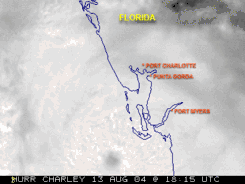
- 2004 Hurricane Charley (08/09 - 08/15) Category 4, total number of deaths (over its entire path) = 15
Hurricane Charley made landfall just south of Charlotte Harbor on Friday, August 13, 2004 at 3:54 P.M. EDT.[19] Charley had reached a maximum sustained wind speed of 150 mph (240 km/h)[20] By the time Charley reached Orlando, its winds had dropped to 95 mph (153 km/h), with gusts as high as 111 mph (179 km/h). Due to the rapid forward movement of Charley the amount of measured rainfall was between 4 and 6 inches.
Damages for Hurricane Charley were as follows:
- Deaths in Florida = 29 (9 direct & 20 indirect)
- Insured Losses in Florida = $6.755 billion (2004 USD)[21]
- Overall estimated damages estimated between $13–15 billion USD[21]
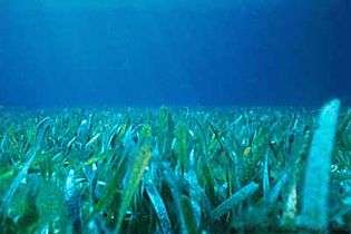 Florida seagrass
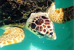 Loggerhead turtle (closeup)
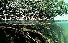 Coastal mangroves
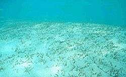 Florida seagrass bed
See also
Notes
- ↑ "Charlotte Harbor Preserve State Park". floridastateparks.org. Retrieved 2007-01-19.
- 1 2 "Charlotte Harbor". National Estuary Program. United States Environmental Protection Agency. Archived from the original on 2006-10-02. Retrieved 2007-01-19.
- ↑ "Bar-Built Estuary". Office of Marine Programs. University of Rhode Island. Archived from the original on 2006-09-11. Retrieved 2007-01-21.
- ↑ "Charlette Harbor National Estuary Program". Retrieved 2007-01-21.
- ↑ "The Charlotte Harbor Aquatic Preserves". dep.state.fl.us. Archived from the original on 2007-02-06. Retrieved 2007-01-19.
- ↑ Poulakis, Gregg R.; Stevens, Philip W.; Timmers, Amy A.; Stafford, Christopher J.; Chapman, Demian D.; Feldheim, Kevin A.; Heupel, Michelle R.; Curtis, Caitlin. "Long-term site fidelity of endangered small-tooth sawfish (Pristis pectinata) from different mothers" (PDF). Fishery Bulletin. 114 (4): 461–475. doi:10.7755/fb.114.4.8.
- ↑ "Encyclopædia Britannica: Charlotte Harbor Inlet, Gulf of Mexico". Retrieved April 28, 2009.
- ↑ "Historic Florida Indians by Wilkinson, Jerry". Retrieved April 28, 2009.
- ↑ "Visit Florida, Charlotte Harbor Area". Archived from the original on March 31, 2009. Retrieved April 28, 2009.
- ↑ Hudson, Charles; Milanich, Jerald T. (1993). Hernando de Soto and the Indians of Florida. Gainesville, FL: University Press of Florida.
- ↑ "DeSoto's Florida Trails". Retrieved April 28, 2009.
- ↑ Duncan, David Ewing (1995). Hernando de Soto, A Savage Quest for the Americas. New York, NY: Crown Publishers, Inc. pp. 255, 486–492.
- ↑ Schell, Rolfe F. (1966). De Soto Didn't Land at Tampa Bay. Fort Myers Beach, FL: Island Press.
- ↑ "Charlotte County History by Norita Shepherd Moss". Retrieved April 28, 2009.
- ↑ Bickel, Karl A. (1942). The Mangrove Coast. Coward McCann, Inc.
- 1 2 dAns, André-Marcel (1980). "The Legend of Gasparilla: Myth and History on Florida's West Coast". Tampa Bay History. Tampa, Florida (Fall/Winter 1980). Retrieved May 20, 2012.
- ↑ Kaserman, James F. & Sarah Jane (2007). "'Pirates of Southwest Florida, Fact and Legend". iUniverse, Inc.: 16–27.
- ↑ "Weather Underground, Tropical Weather, Hurricane Archive: All Atlantic Storms (1851-2009)". Retrieved April 28, 2009.
- ↑ "NOAA Service Assessment, Hurricane Charley August 9–15, 2004" (PDF).
- ↑ "NASA's Hurricane Portal, Hurricane Charley".
- 1 2 "NWS, National Hurricane Center, Tropical Weather Summary".
External links
- Estuaries Classified by Geologic Features
- Charlotte Harbor Environmental Center
- Charlotte Harbor Watershed - Florida DEP
- Charlotte Harbor State Park
- Charlotte Harbor National Estuary Program
- Charlotte Harbor Aquatic Preserve
- Florida Disaster.org, Hurricane Charley August 13, 2004 - Charlotte County Damage Photos
- Charlotte Harbor Water Atlas
Coordinates: 26°46′33″N 82°08′31″W / 26.77583°N 82.14194°W
Municipalities and communities of Charlotte County, Florida, United States | ||
|---|---|---|
| City | 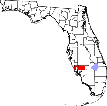 | |
| CDPs | ||
| Unincorporated communities | ||
| Ghost town | ||
| Footnotes | ‡This populated place also has portions in an adjacent county or counties | |