Caloosahatchee River
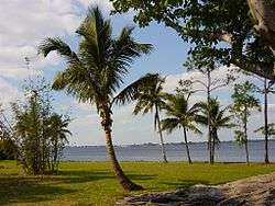
The Caloosahatchee River is a river on the southwest Gulf Coast of Florida in the United States, approximately 67 miles (108 km) long.[1] It drains rural areas on the northern edge of the Everglades, east of Fort Myers. An important link in the Okeechobee Waterway, a manmade inland waterway system of southern Florida, the river forms a tidal estuary along most of its course and has recently become the subject of efforts to restore and preserve the Everglades.
Description
The river issues from Lake Hicpochee, in southeastern Glades County, approximately 10 mi (16 km) west of Clewiston. It flows west-southwest past LaBelle, where it becomes tidal, forming an estuary along its lower 25 mi (40 km). It broadens as it nears the gulf, passing Fort Myers and Cape Coral. It enters the Gulf of Mexico 10 mi (16 km) southwest of Fort Myers in San Carlos Bay, protected by Sanibel Island.
The 5 mi (8 km) Caloosahatchee Canal connecting Lake Hicpochee to Lake Okeechobee allows continuous navigation from the Caloosahatchee to the Okeechobee Waterway system; oxbow lakes mark isolated stretches of the original waterway.[2] In 2013 heavy rains in southern Florida resulted in high runoff into Lake Okeechobee; rising lake levels forced the United States Army Corps of Engineers to release large volumes of polluted water from the lake through the St. Lucie River estuary to the east and the Caloosahatchee River estuary to the west. Thus the normal mix of fresh and salt water in those estuaries was replaced by a flood of polluted fresh water resulting in ecological damage.[3]
Since the late 19th century, dredging and channelization of the river, as well as the artificial connection to Lake Okeechobee and its use as a water supply for urban and agricultural uses, have substantially altered the hydrology of the river. As a result, both the magnitude and timing of water delivery to the estuary have been substantially altered. Recent programs by the state government have attempted to establish minimum flow levels in the river, in part to help restore the water supply to the Everglades. A federal wildlife refuge for manatees has been established at the mouth of the river on San Carlos Bay near Fort Myers.
Crossings
The following is a list of bridge crossings of the Caloosahatchee River and Canal
| Bridge | Route | Location | Notes | |
|---|---|---|---|---|
| South Central Florida Express, Inc. | Moore Haven | Swing Bridge | ||
| Mamie Langdale Memorial Bridge | Moore Haven | |||
| LaBelle | Bascule Bridge | |||
| Fort Denaud Bridge | Fort Denaud Road | Fort Denaud | Swing Bridge | |
| Alva Bridge | Broadway | Alva | ||
| Wilson Pigott Bridge | Fort Myers Shores | |||
| Tice | ||||
| Seminole Gulf Railway | Tice | Bascule bridge | ||
| Edison Bridge | Fort Myers | |||
| Caloosahatchee Bridge | Fort Myers | |||
| Midpoint Memorial Bridge | Cape Coral | |||
| Cape Coral Bridge | Cape Coral |
Gallery
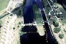 Ortona Lock and Dam on the Caloosahatchee River, part of the Okeechobee Waterway, in Glades County, Florida
 Seminole Gulf Railway spans the Caloosahatchee River near Tice, Florida.
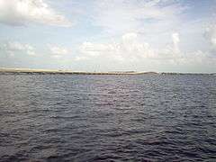 The Midpoint Memorial Bridge spanning the river and connecting the cities of Cape Coral and Fort Myers (2008).
See also
References
- ↑ U.S. Geological Survey. National Hydrography Dataset high-resolution flowline data. The National Map Archived 2012-04-05 at WebCite, accessed April 18, 2011
- ↑ Betsey Clayton, "Navigating the Caloosahatchee River".
- ↑ Lizette Alvarez (September 8, 2013). "In South Florida, a Polluted Bubble Ready to Burst". The New York Times. Retrieved September 9, 2013.
External links
- South Florida Water Management District: Caloosahatchee River and Estuary
- GulfBase.org: Caloosahatchee River
- USFWS: Caloosahatchee River-San Carlos Bay Federal Manatee Refuge
- Caloosahatchee River Citizens Association (Riverwatch)
- Caloosahatchee River Watershed - Florida DEP
| People | |
|---|---|
| Protected areas | |
| Bodies of water | |
| See also | |
| |
Coordinates: 26°31′01″N 82°01′59″W / 26.5170225°N 82.0331467°W