Kohlsaat, West Virginia
| Kohlsaat | |
|---|---|
| Unincorporated community | |
 Kohlsaat Location within the state of West Virginia  Kohlsaat Kohlsaat (the US) | |
| Coordinates: 37°56′30″N 81°42′16″W / 37.94167°N 81.70444°WCoordinates: 37°56′30″N 81°42′16″W / 37.94167°N 81.70444°W | |
| Country | United States |
| State | West Virginia |
| County | Boone |
| Elevation | 860 ft (260 m) |
| Time zone | UTC-5 (Eastern (EST)) |
| • Summer (DST) | UTC-4 (EDT) |
| GNIS ID | 1554895[1] |
Kohlsaat is an unincorporated community in Boone County, West Virginia. Part of Kohlsaat, became Marthatown.
References
Municipalities and communities of Boone County, West Virginia, United States | ||
|---|---|---|
| City | 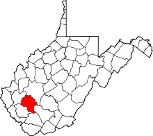 | |
| Towns | ||
| CDPs | ||
| Unincorporated communities |
| |
| Footnotes | ‡This populated place also has portions in an adjacent county or counties | |
This article is issued from
Wikipedia.
The text is licensed under Creative Commons - Attribution - Sharealike.
Additional terms may apply for the media files.