Bald Knob, West Virginia
| Bald Knob, West Virginia | |
|---|---|
| Unincorporated community | |
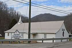 Methodist church | |
 Bald Knob, West Virginia  Bald Knob, West Virginia | |
| Coordinates: 37°52′15″N 81°38′08″W / 37.87083°N 81.63556°WCoordinates: 37°52′15″N 81°38′08″W / 37.87083°N 81.63556°W | |
| Country | United States |
| State | West Virginia |
| County | Boone |
| Elevation | 1,093 ft (333 m) |
| Time zone | UTC-5 (Eastern (EST)) |
| • Summer (DST) | UTC-4 (EDT) |
| ZIP code | 25010 |
| Area code(s) | 304 & 681 |
| GNIS feature ID | 1535163[1] |
Bald Knob is an unincorporated community in Boone County, West Virginia, United States. Bald Knob is located on West Virginia Route 85 17 miles (27 km) southeast of Madison. Bald Knob had a post office, which closed on October 1, 2005.[2] The community took its name from nearby Bald Knob peak.[3]
References
- ↑ U.S. Geological Survey Geographic Names Information System: Bald Knob, West Virginia
- ↑ "Postmaster Finder - Post Offices by ZIP Code". United States Postal Service. Retrieved September 26, 2011.
- ↑ Kenny, Hamill (1945). West Virginia Place Names: Their Origin and Meaning, Including the Nomenclature of the Streams and Mountains. Piedmont, WV: The Place Name Press. p. 93.
Municipalities and communities of Boone County, West Virginia, United States | ||
|---|---|---|
| City | 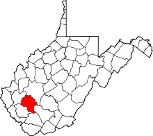 | |
| Towns | ||
| CDPs | ||
| Unincorporated communities |
| |
| Footnotes | ‡This populated place also has portions in an adjacent county or counties | |
This article is issued from
Wikipedia.
The text is licensed under Creative Commons - Attribution - Sharealike.
Additional terms may apply for the media files.