Twilight, West Virginia
| Twilight | |
|---|---|
| Census-designated place (CDP) | |
 Twilight Location within the state of West Virginia | |
| Coordinates: 37°55′38″N 81°37′24″W / 37.92722°N 81.62333°WCoordinates: 37°55′38″N 81°37′24″W / 37.92722°N 81.62333°W | |
| Country | United States |
| State | West Virginia |
| County | Boone |
| Area[1] | |
| • Total | 0.502 sq mi (1.30 km2) |
| • Land | 0.501 sq mi (1.30 km2) |
| • Water | 0.001 sq mi (0.003 km2) |
| Population (2010)[2] | |
| • Total | 90 |
| • Density | 180/sq mi (69/km2) |
| Time zone | UTC-5 (Eastern (EST)) |
| • Summer (DST) | UTC-4 (EDT) |
| ZIP codes | 25204 |
| GNIS feature ID | 1548396 |
Twilight is a census-designated place (CDP) in Boone County, West Virginia, United States.[3] As of the 2010 census, its population was 90.[2] Twilight is approximately 20 miles from Madison. Twilight is accessible from Boone County Route 26, which is located right off West Virginia Route 85 at the Van Bridge split.
The name Twilight was chosen by the United States Postal Service in 1949 out of several names submitted. The ZIP code for Twilight is 25204.
References
- ↑ "US Gazetteer files: 2010, 2000, and 1990". United States Census Bureau. 2011-02-12. Retrieved 2011-04-23.
- 1 2 "American FactFinder". United States Census Bureau. Retrieved 2011-05-14.
- ↑ U.S. Geological Survey Geographic Names Information System: Twilight, West Virginia
Municipalities and communities of Boone County, West Virginia, United States | ||
|---|---|---|
| City | 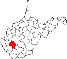 | |
| Towns | ||
| CDPs | ||
| Unincorporated communities |
| |
| Footnotes | ‡This populated place also has portions in an adjacent county or counties | |
This article is issued from
Wikipedia.
The text is licensed under Creative Commons - Attribution - Sharealike.
Additional terms may apply for the media files.