Al-Qastal, Jerusalem
| al-Qastal | |
|---|---|
 al-Qastal hill | |
 al-Qastal | |
| Arabic | القسطل |
| Name meaning | "castellum" or castale[1] |
| Subdistrict | Jerusalem |
| Coordinates | 31°47′44″N 35°8′39″E / 31.79556°N 35.14417°ECoordinates: 31°47′44″N 35°8′39″E / 31.79556°N 35.14417°E |
| Palestine grid | 163/133 |
| Population | 90[2] (1945) |
| Area |
1,446 dunams 1.4 km² |
| Date of depopulation | April 3, 1948[3] |
| Cause(s) of depopulation | Military assault by Yishuv forces |
| Current localities | Mevaseret Zion[4] |
Al-Qastal ("Kastel", Arabic: القسطل) was a Palestinian village located eight kilometers west of Jerusalem named for a Crusader castle located on the hilltop. Used as a military base by the Army of the Holy War, the village was captured by the Palmach in the lead up to the Arab-Israeli War and depopulated of its residents.
History
Crusader period
A Crusader castle called Belveer or Beauverium was built there around 1168 CE. It is listed among the castles destroyed by Sultan al-Adil I in 1191–92 CE. No trace remains today of the castle.[5] Belveer is mentioned in a letter from Eraclius, Patriarch of Jerusalem, dated September 1187, in which he describes the slaughter of Christians "by the sword of Mafumetus the Unbeliever and his evil worshipper Saladin" and the Arab conquest of the town, which was renamed Qastal.[6]
Ottoman period
In 1838 el-Kustul was noted as a Muslim village, part of Beni Malik area, located west of Jerusalem.[7]
In 1863, Victor Guérin found modern buildings on ancient ruins. He noted that the village belonged to the Abu Ghosh clan.[8] An Ottoman village list from about 1870 found that Kastal had a population of 10, in 5 houses; the population count included only men.[9][10]
In 1883, al-Qastal was described as "a small stone village in a conspicuous position on a rocky hill-top" with springs to the east.[11]
In 1896 the population of El-kastal was estimated to be about 39 persons.[12]
British Mandate period
In the 1922 census of Palestine conducted by the British Mandate authorities, Qastal had a population 43, all Muslims,[13] increasing in the 1931 census to 59; 55 Muslims and 4 Christians, in a total of 14 houses.[14]
In 1944/45, the village, with a population of 90 Muslims,[2] had a total of 42 dunums of land allocated to cereals. 169 dunums were irrigated or used for orchards, including 50 dunams of olive trees.[4][15]
1948, aftermath
In 1948, al-Qastal was a key position on the Jaffa-Jerusalem road and was used by Arab forces to attack Jewish relief convoys so as to prevent them from reaching the besieged Jewish parts of Jerusalem.[16] For this purpose it was occupied by the Army of the Holy War led by Abd al-Qadir al-Husayni, the commander of the Jerusalem Hills sector.[17]
The village was assaulted by the Palmach's Harel Brigade and two squads of the Haganah during Operation Nachshon, after a previous minor clash had already caused most civilian inhabitants to flee.[4][18] Palmach troops occupied the village on April 3, but its commander was refused permission to blow up the houses.[18]
Forces under Abd al-Qadir al-Husayni attacked and besieged the Haganah-held village on 7 April 1948. During the following, foggy night Al-Husayni himself was killed by a Haganah sentinel in a bizarre incident. On April 8, armed Arabs from the entire area, motivated by the disappearance of their leader, attacked and recaptured al-Qastal.[18] However, Al-Husayni's death is said to have led to a loss of morale among his forces.[19] Most fighters left their positions to attend al-Husayni's funeral at the Al-Aqsa Mosque on Friday, April 9. Palmach troops retook the almost fully deserted village on the night of April 8-9th; they blew up most of the houses and made the hill a command post, which they managed to hold on to.[18][20]
Parts of the Israeli town of Mevaseret Zion are located on the former lands of Al-Qastal.[4]
Gallery
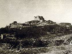
 View of Qastal before Operation Nachshon
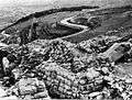 View of the road from Qastal
 Palestinian irregulars moving to counterattack Haganah positions in Al-Qastal, 7–8 April 1948
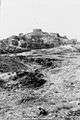
 Approach to Qastal from the air, 1948
 Harel Brigade mortar in action during battle for Qastal
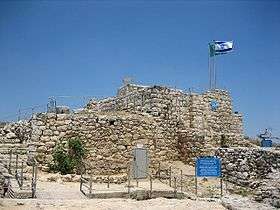 Castel fortress, 2006
See also
References
- ↑ Palmer, 1881, p. 322
- 1 2 Department of Statistics, 1945, p. 25
- ↑ Morris, 2004, p. xx, village #356. Also gives cause of depopulation.
- 1 2 3 4 Khalidi, 1992, p.311
- ↑ Denys Pringle (1997). Qastal (R15). Secular buildings in the Crusader Kingdom of Jerusalem: an archaeological gazetteer. Cambridge: Cambridge University Press. p. 118. Retrieved 28 December 2015.
No trace of any Frankish structures, despite contrary claims.
- ↑ Letters from the East: Crusaders, Pilgrims and Settlers in the 12th-13th Centuries, Keith Bate, Malcolm Barber, A.K. Bate
- ↑ Robinson and Smith, 1841, vol 3, Appendix 2, p. 123
- ↑ Guérin, 1868, p. 264
- ↑ Socin, 1879, p. 156
- ↑ Hartmann, 1883, p. 118, also noted 5 houses
- ↑ Conder and Kitchener, 1883, III:18. Quoted in Khalidi, 1992, p.310
- ↑ Schick, 1896, p. 125
- ↑ Barron, 1923, Table VII, Sub-district of Jerusalem, p. 14
- ↑ Mills, 1932, p. 32
- ↑ Government of Palestine, Department of Statistics. Village Statistics, April, 1945. Quoted in Hadawi, 1970, pp. 58, 103
- ↑ War for the Jerusalem Road, Time, Apr. 19, 1948.
- ↑ Morris, 2008, p. 123
- 1 2 3 4 Morris, 2004, pp. 234–235.
- ↑ Morris, 2008, p. 125
- ↑ Benveniśtî, 2002, p. 111
Bibliography
- Barron, J. B., ed. (1923). Palestine: Report and General Abstracts of the Census of 1922. Government of Palestine.
- Benvenisti, Meron (2002). Sacred Landscape: The Buried History of the Holy Land Since 1948. University of California Press. ISBN 978-0-520-23422-2.
- Conder, Claude Reignier; Kitchener, H. H. (1883). The Survey of Western Palestine: Memoirs of the Topography, Orography, Hydrography, and Archaeology. 3. London: Committee of the Palestine Exploration Fund.
- Department of Statistics (1945). Village Statistics, April, 1945. Government of Palestine.
- Guérin, Victor (1868). Description Géographique Historique et Archéologique de la Palestine (in French). 1: Judee, pt. 1. Paris: L'Imprimerie Nationale.
- Hadawi, Sami (1970). Village Statistics of 1945: A Classification of Land and Area ownership in Palestine. Palestine Liberation Organization Research Center.
- Hartmann, M. (1883). "Die Ortschaftenliste des Liwa Jerusalem in dem türkischen Staatskalender für Syrien auf das Jahr 1288 der Flucht (1871)". Zeitschrift des Deutschen Palästina-Vereins. 6: 102–149.
- Khalidi, Walid (1992). All That Remains: The Palestinian Villages Occupied and Depopulated by Israel in 1948. Washington D.C.: Institute for Palestine Studies. ISBN 0-88728-224-5.
- Mills, E., ed. (1932). Census of Palestine 1931. Population of Villages, Towns and Administrative Areas. Jerusalem: Government of Palestine.
- Morris, Benny (2004). The Birth of the Palestinian Refugee Problem Revisited. Cambridge University Press. ISBN 978-0-521-00967-6.
- Morris, Benny (2008), 1948: A History of the First Arab-Israeli War, Yale University Press ISBN 0-300-15112-8
- Palmer, E. H. (1881). The Survey of Western Palestine: Arabic and English Name Lists Collected During the Survey by Lieutenants Conder and Kitchener, R. E. Transliterated and Explained by E.H. Palmer. Committee of the Palestine Exploration Fund.
- Pringle, Denys (1997). Secular buildings in the Crusader Kingdom of Jerusalem: an archaeological Gazetter. Cambridge University Press. ISBN 0521 46010 7.
- Robinson, Edward; Smith, Eli (1841). Biblical Researches in Palestine, Mount Sinai and Arabia Petraea: A Journal of Travels in the year 1838. 3. Boston: Crocker & Brewster.
- Schick, C. (1896). "Zur Einwohnerzahl des Bezirks Jerusalem". Zeitschrift des Deutschen Palästina-Vereins. 19: 120–127.
- Socin, A. (1879). "Alphabetisches Verzeichniss von Ortschaften des Paschalik Jerusalem". Zeitschrift des Deutschen Palästina-Vereins. 2: 135–163.
External links
- Welcome To al-Qastal
- al-Qastal, Zochrot
- Survey of Western Palestine, Map 17: IAA, Wikimedia commons
- Al-Qastal from the Khalil Sakakini Cultural Center
- Al-Qastal, Palestine Family.net
| |||||
| |||||