Qalansawe
Qalansawe
| |
|---|---|
| Hebrew transcription(s) | |
| • ISO 259 | Qalansuwa |
| • Translit. | Kalansuwa or Qalansuwa |
| • Also spelled | Kalansoueh,[1] Qalansuwa (unofficial) |
 | |
 Qalansawe | |
| Coordinates: 32°16′56.34″N 34°59′0.27″E / 32.2823167°N 34.9834083°ECoordinates: 32°16′56.34″N 34°59′0.27″E / 32.2823167°N 34.9834083°E | |
| Grid position |
198600/687800 ITM 148/187 PAL |
| District | Central |
| Government | |
| • Type | City |
| • Mayor | Abdulbast Salameh |
| Area | |
| • Total | 8,400 dunams (8.4 km2 or 3.2 sq mi) |
| Population (2017)[2] | |
| • Total | 22,370 |
| • Density | 2,700/km2 (6,900/sq mi) |
Qalansawe also Qalansuwa (Arabic: قلنسوة, Hebrew: קַלַנְסֻוָה, lit. "turban")[3][4] is an Arab city in the Central District of Israel. Part of the Triangle, in 2017 it had a population of 22,370.[2]
History

From the ninth century and until the Crusader times, Qalansawe was a stop on the Cairo-Damascus road, between Lajjun and Ramla.[5]
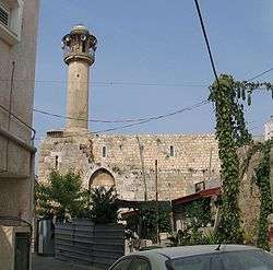
During the Crusader period, the village was known as Calanson, Calansue, Calanzon or Kalensue.[6] In 1128, it was given to the Hospitallers by the knight Godfrey of Flujeac.[6][7] Yaqut (†1229) wrote that Qalansawe, Castle of the Plans, of the Crusaders, was a fortress near Ramle. He adds that "many of the Omayyads were slain there."[8] Remnants of a crusader fortress remain today.[6] It remained in Hospitallers hands (except for 1187–1191) until Baybars took it in 1265.[6] However, during this period the lord of Caesarea appears to have retained overlordship.[6]
In 1265, after the Mamluks had defeated the Crusaders, Qalansawe was mentioned among the estates which Sultan Baibars granted his followers. It was divided equally between two of his emirs: 'Izz al-Din Aidamur al-Halabi al-Salihi and Shams al-Din Sunqur al-Rumi al-Salihi.[9]
Ottoman period
In 1517, the village was included in the Ottoman Empire with the rest of Palestine, and in the 1596 tax-records it appeared located in the Nahiya of Bani Sa'b of the Liwa of Nablus. It had a population of 29 Muslim households. They paid a fixed tax-rate of 33.3% on agricultural products, including wheat, barley, summer crops, olives, goats or beehives, and a press for olives or grapes; a total of 11,342 akçe.[10] Pierre Jacotin called the village Qalensawi on his map from 1799.[11]
In 1870 the French explorer Victor Guérin found it to have 500 inhabitants.[1] He then "examined the remains of a beautiful church, built east and west, and divided into three naves, terminating to the east in three apses. It was formerly constructed of good cut stones, some of which were slightly embossed, as is proved by the portions still standing. The naves were separated one from the other by monolithic columns, only the positions of which can be traced. They were probably crowned by Corinthian capitals, for I found one in a house, of white marble, cut into a mortar by the inhabitants, who told me they brought it from the site of the church. The other capitals and shafts had disappeared. Probably they came from some more ancient building. An elegant door, with pointed arch, is still standing. Under the nave runs a vaulted crypt, now divided into several compartments, which serve as a shelter for as many families. The good walls seem ancient. One of these is near the church; the other below the village. The latter is large, and surmounted by a vaulted arcade in cut stones."[12]
In 1882, the Palestine Exploration Fund's Survey of Western Palestine described it as being of moderate size, and the seat of a Caimacam. In the centre of the village was a Crusader tower and hall, surrounded by the village houses, mostly made of adobe. Wells and a spring to the west supplied water.[13]
British Mandate of Palestine period
In the 1922 census of Palestine conducted by the British Mandate authorities, Qualansawe had a population of 871, Muslims,[14] increasing in the 1931 census to 1069, still all Muslim, in a total of 225 houses.[15]
By the 1945 statistics, the village had 1540 Muslim inhabitants,[16] who owned a total of owned 17,249 dunams of land.[17] 473 dunams were for citrus and bananas, 759 plantations and irrigable land, 15,936 for cereals,[18] while 47 dunams were built-up (urban) land.[19]
1948, and after
During the 1948 Palestine war, Jewish forces had decided to "conquer and destroy" or later "expel or subdue" Qalansawe,[20] but the village was not taken[21] and was only transferred to Israeli sovereignty in May 1949 as part of the Israel-Jordan armistice agreement.[22] Political considerations then prevented the expulsion of the villagers.[23]
By 1962, land ownership had dropped to 6,620 dunams, mostly due to expropriation of land by the Israeli government in 1953–1954.[24]
In January 2017, the Israeli government demolished 11 buildings being built by 4 families, on the grounds that they were built without permits.[25] The families were given two days notice, which they said was insufficient for any legal response.[25] The mayor of Qalansawe, who announced his resignation, said that he had fought unsuccessfully for years for an expansion of the town's building plan, forcing the residents to build on agricultural land.[26] Thousands of people rallied in support of the village and a one-day strike was called.[26][27]
Demographics
In 2001, the ethnic makeup of the city was virtually all Arab Muslims without significant Jewish population. There were 7,700 males and 7,300 females. 53.2% of the residents were 19 years of age or younger, 17.1% were between 20 and 29, 17.9% between 30 and 44, 8.0% from 45 to 59, 1.6% from 60 to 64, and 2.2% 65 years of age or older. The population growth rate in 2001 was 3.5%.
Due to marriages among relatives, the residents suffer from a high percentage of genetic diseases, especially hearing impairment.[28]
See also
References
- 1 2 Guerin, 1875, p. 350
- 1 2 "List of localities, in Alphabetical order" (PDF). Israel Central Bureau of Statistics. Retrieved August 26, 2018.
- ↑ The turban tradition in Islam
- ↑ Palmer, 1881, p.187
- ↑ Petersen, 2001, pp. 248-249, citing among others Hartmann, 1910, 675, 676
- 1 2 3 4 5 Pringle, 1997, pp. 77 - 78
- ↑ Röhricht, 1904, RRH Ad, pp. 9-10, No. 121a
- ↑ Cited in le Strange, 1890, p.476
- ↑ Ibn al-Furat, 1971, pp. 8o, 210, 249 (map)
- ↑ Hütteroth and Abdulfattah, 1977, p. 139
- ↑ Karmon, 1960, p. 170 Note that Karmon gives the wrong grid-numbers for Qalansawe
- ↑ Guérin, 1875, pp. 350-352, 354 as translated in Conder and Kitchener, 1882, SWP II, pp. 201
- ↑ Conder and Kitchener, 1882, SWP II, p. 165
- ↑ Barron, 1923, Table IX, Sub-district of Tulkarem, p. 28
- ↑ Mills, 1932, p. 56
- ↑ Department of Statistics, 1945, p. 21
- ↑ Government of Palestine, Department of Statistics. Village Statistics, April, 1945. Quoted in Hadawi, 1970 p. 76
- ↑ Government of Palestine, Department of Statistics. Village Statistics, April, 1945. Quoted in Hadawi, 1970, p. 127
- ↑ Government of Palestine, Department of Statistics. Village Statistics, April, 1945. Quoted in Hadawi, 1970, p. 177
- ↑ Morris, 2004, p. 246
- ↑ Morris, 2004, p. 302
- ↑ UN Doc S/1302/Rev.1 of 3 April 1949 Archived 12 June 2012 at the Wayback Machine.
- ↑ Morris, 2004, p. 531
- ↑ S. Jiryis (1976). "The land question in Israel". MERIP Reports. No. 37: 5–20, 24–26.
- 1 2 Jack Khoury (Jan 10, 2017). "Israel Demolishes Buildings in Arab Town, Citing Lack of Permits". Haaretz.
- 1 2 Jack Khoury (Jan 13, 2017). "Thousands Rally in Israeli Arab Town After State Demolishes Homes". Haaretz.
- ↑ AFP (January 11, 2017). "Israeli Arabs strike in protest at house demolitions". Al-Monitor.
- ↑ Warzberger, Rachel (2001-03-19). "Close Family Marriages and Polygamy" (RTF) (in Hebrew). Knesset. Retrieved 2008-07-26.
Bibliography
- Barron, J.B., ed. (1923). Palestine: Report and General Abstracts of the Census of 1922. Government of Palestine.
- Conder, C.R.; Kitchener, H.H. (1882). The Survey of Western Palestine: Memoirs of the Topography, Orography, Hydrography, and Archaeology. 2. London: Committee of the Palestine Exploration Fund. (pp. 199-201.)
- Department of Statistics (1945). Village Statistics, April, 1945. Government of Palestine.
- Doumani, B. (1995). Rediscovering Palestine, Merchants and Peasants in Jabal Nablus, 1700–1900. University of California Press. Retrieved 2011-11-07. p. 19
- Guérin, V. (1875). Description Géographique Historique et Archéologique de la Palestine (in French). 2: Samarie, pt. 2. Paris: L'Imprimerie Nationale.
- Hadawi, S. (1970). Village Statistics of 1945: A Classification of Land and Area ownership in Palestine. Palestine Liberation Organization Research Center.
- Hartmann, Richard (1910): Die Straße von Damaskus nach Kairo Zeitschrift der Deutschen Morgenländischen Gesellschaft › Bd. 64 (Cited in Petersen, 2001)
- Hütteroth, Wolf-Dieter; Abdulfattah, Kamal (1977). Historical Geography of Palestine, Transjordan and Southern Syria in the Late 16th Century. Erlanger Geographische Arbeiten, Sonderband 5. Erlangen, Germany: Vorstand der Fränkischen Geographischen Gesellschaft. ISBN 3-920405-41-2.
- Ibn al-Furat (1971). J. Riley-Smith, ed. Ayyubids, Mamluks and Crusaders: Selections from the "Tarikh Al-duwal Wal-muluk" of Ibn Al-Furat : the Text, the Translation. 2. Translation by Malcolm Cameron Lyons, Ursula Lyons. Cambridge: W. Heffer.
- Karmon, Y. (1960). "An Analysis of Jacotin's Map of Palestine" (PDF). Israel Exploration Journal. 10 (3, 4): 155–173, 244–253.
- Mills, E., ed. (1932). Census of Palestine 1931. Population of Villages, Towns and Administrative Areas. Jerusalem: Government of Palestine.
- Morris, B. (2004). Birth of the Palestinian Refugee Problem Revisited. Cambridge University Press. ISBN 0-521-00967-7.
- Mukaddasi (1886). Description of Syria, including Palestine. London: Palestine Pilgrims' Text Society. (pp. 95, 97)
- Palmer, E.H. (1881). The Survey of Western Palestine: Arabic and English Name Lists Collected During the Survey by Lieutenants Conder and Kitchener, R. E. Transliterated and Explained by E.H. Palmer. Committee of the Palestine Exploration Fund.
- Petersen, Andrew (2001). A Gazetteer of Buildings in Muslim Palestine (British Academy Monographs in Archaeology). 1. Oxford University Press. ISBN 978-0-19-727011-0.
- Pringle, Denys (1997). Secular buildings in the Crusader Kingdom of Jerusalem: an archaeological Gazetter. Cambridge University Press. ISBN 0521 46010 7.
- Pringle, Denys (1998). The Churches of the Crusader Kingdom of Jerusalem: L-Z (excluding Tyre). II. Cambridge University Press. ISBN 0 521 39037 0. (p. 161)
- Robinson, E.; Smith, E. (1841). Biblical Researches in Palestine, Mount Sinai and Arabia Petraea: A Journal of Travels in the year 1838. 3. Boston: Crocker & Brewster. (p. 47)
- Röhricht, R. (1904). (RRH Ad) Regesta regni Hierosolymitani Additamentum (in Latin). Berlin: Libraria Academica Wageriana.
- Strange, le, G. (1890). Palestine Under the Moslems: A Description of Syria and the Holy Land from A.D. 650 to 1500. Committee of the Palestine Exploration Fund.
External links
- Welcome To Qalansiwa
- Survey of Western Palestine, Map 11: IAA, Wikimedia commons
| |||||
| |||||