Al-Haram, Jaffa
| Al-Haram | |
|---|---|
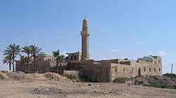 Sidna Ali Mosque in Al-Haram | |
| Subdistrict | Jaffa |
| Palestine grid | 131/177 |
| Population | 520[1][2] (1945) |
| Area | 2,681[2] dunams |
| Date of depopulation | 3 February 1948[3] |
| Cause(s) of depopulation | Fear of being caught up in the fighting |
Al-Haram (El Haram ʿAly Ibn ʿAleim, also Sayyiduna Ali or Sidna Ali "sanctuary of ʿAli [Ibn ʿAleim]"[4]), was a Palestinian Arab village in the Jaffa Subdistrict,[5] in Mandatory Palestine. It was located 16 km north of Jaffa, adjacent to the ruins of the medieval fortress of Arsuf, and its extent was estimated to range between 9,653 and 11,698 dunams of which 5,150 were accounted for in the cadastral registrations.[5] It was depopulated during the 1948 war.
History
Medieval
The medieval fortress of Arsuf was captured from the kingdom of Jerusalem by Baibars in 1265, after 40 days of siege. Its inhabitants were killed or sold as slaves and the town completely razed.[6] The site was completely abandoned for about a century, according to the geographer Abulfeda (writing in c. 1330), the site contained no inhabitants ("Tabula Syriæ", 82). It appears that a minor village was re-established in the 16th century in the vicinity of the Sidna Ali Mosque, mentioned by Mujir al-Din (writing c. 1496) as having been dedicated at the site the tomb of the saint, ʿAli Ibn ʿAleim (d. 1081), where he prayed for victory prior to retaking Arsuf.[7][8]
Ottoman period
In 1596, in the Ottoman era, a third of the revenues from nearby Arsuf went to the waqf of ʿAli Ibn ʿAleim.[9] Pierre Jacotin called the village Ali Ebn harami on his map from 1799.[10] In 1880, it was described as a adobe village of moderate size on high ground, with springs to the north, and on the west a mosque. The full name was recorded as El Haram 'Aly Ibn 'Aleim.[11]
Period of the British mandate
In the 1922 census of Palestine conducted by the British Mandate authorities, Al-Haran had a population of 172, all Muslims[12] increasing the 1931 census to 313, still all Muslims, in a total of 83 houses.[13]
During the 1920s, the Palestine Land Development Company (PLDC) bought part of the village land on behalf of the American Zion Commonwealth from the Omri family of Beirut, to found the settlement of Herzliya.[14][15] Later purchases of village land by the PLDC, Jewish National Fund, Keren Hayesod and private Jewish buyers was used to establish Kfar Shmaryahu and Rishpon.[16][17] At the time, during the Palestinian revolt against the British mandate 2 al-Haram villagers were brought before the rebel leader Aref Abd al-Razeq, and condemned for having sold land there to the Jews, as the documented proved.[18] According to some testimonies,[19] the relationship between the villagers of Al-Haram and the Jews of Herzliya and Rishpon was friendly. The early settlers of Herzliya mention Arab peddlers in the streets of the town. Some of the villagers were employed in construction. Former Arab residents of al-Haram testified that before the war, representatives of the Jewish towns assured them they were safe.[20]
In the 1945 statistics the village had a population of 880, with 360 Jewish inhabitants. al-Haram had an elementary school for boys founded in 1921, and in 1945 it had an enrollment of 68 students. The village also contained a mosque and a shrine for al-Hasan ibn 'Ali (d. A.D. 1081), who was a descendant of the second Muslim Caliph 'Umar ibn al-Khattab.[17]
According to Morris, the villagers were evacuated on 3 February 1948 out of fear of Jewish attack, after Haganah or Irgun attacks on nearby villages.[21]
Today
The only trace of the former village is the Sidna Ali shrine and the cemetery which surrounds it. The cemetery has been developed as a parking lot for Israeli tourists.[5]
References
- ↑ Government of Palestine, Department of Statistics, 1945, p. 27
- 1 2 Government of Palestine, Department of Statistics. Village Statistics, April, 1945. Quoted in Hadawi, 1970, p. 52
- ↑ Morris, 2004, p. xviii, village #195
- ↑ Palmer, 1881, p. 174
- 1 2 3 Essaid, 2014, pp. 175-213
- ↑ Gestes des Chiprois, Part III, p.117, ed. Gaston Raynaud, Genève, 1887: The year given by the chronicler known as the Templar of Tyre is 1265.
- ↑ Taragan, Hana (2004): The Tomb of Sayyidna Ali in Arsuf: the Story of a Holy Place In JRAS (Journal of the Royal Asiatic Society), Series 4, 14, 2 (2004), pp. 83–102.
- ↑ Essaid, 2014, p. 175 writes: 'The village of Al-Haram was also known as Sayyiduna 'Ali (generally spelt as Sida 'Ali), meaning 'our lord 'Ali,' because it was built round the shrine of a descendant of 'Umar ibn al-Khatab named al-Hasan ibn 'Ali, who died in ad 1081. However another source claims that the name came from the fighter Abi Hasan 'Ali ibn 'Ulail, who was from the clan of 'Umar ibn al-Khatab, since Abi Hasan 'Abi ibn 'Ulail was known generally by the name of 'Ali ibn 'Alim.'
- ↑ Hütteroth and Abdulfattah, 1977, p. 140
- ↑ Karmon, 1960, p. 170
- ↑ Conder and Kitchener, 1882, SWP II, p. 134.
- ↑ Barron, 1923, Table VII, Sub-district of Jaffa, p. 20
- ↑ Mills, 1932, p. 13.
- ↑ Avneri, 1982, pp. 70, 176
- ↑ Glass, 2002, p. 207
- ↑ Essaid, 2014, p. 180
- 1 2 Khalidi, 1992, pp. 240-241
- ↑ Hillel Cohen, Army of Shadows: Palestinian Collaboration with Zionism, 1917–1948, University of California Press, 2008
- ↑ Herzliya, "Mother of the Kibbutzim and the Communal Groups", by Dan Yahav. Yaron Golan Publishers.
- ↑ http://www.nakbainhebrew.org/index.php?id=300 Archived November 10, 2007, at the Wayback Machine.
- ↑ Morris, 2004, p. 129, note 514.
Bibliography
| Wikimedia Commons has media related to Sidna Ali Mosque. |
- Avneri, Arieh L. (1982). The Claim of Dispossession: Jewish Land-settlement and the Arabs, 1878-1948. Transaction Publishers. ISBN 0-87855-964-7.
- Barron, J.B., ed. (1923). Palestine: Report and General Abstracts of the Census of 1922. Government of Palestine.
- Canaan, T. (1927). Mohammedan Saints and Sanctuaries in Palestine. London: Luzac & Co. (p. 215; cited in Petersen, 2001)
- Conder, C.R.; Kitchener, H.H. (1882). The Survey of Western Palestine: Memoirs of the Topography, Orography, Hydrography, and Archaeology. 2. London: Committee of the Palestine Exploration Fund.
- Essaid, Aida (2014). Zionism and Land Tenure in Mandate Palestine. Routledge. pp. 175–213.
- Glass, Joseph B. (2002). From new Zion to old Zion : American Jewish immigration and settlement in Palestine, 1917 - 1939. Wayne State University Press. ISBN 0814328423.
- Government of Palestine, Department of Statistics (1945). Village Statistics, April, 1945.
- Hadawi, S. (1970). Village Statistics of 1945: A Classification of Land and Area ownership in Palestine. Palestine Liberation Organization Research Center.
- Hütteroth, Wolf-Dieter; Abdulfattah, Kamal (1977). Historical Geography of Palestine, Transjordan and Southern Syria in the Late 16th Century. Erlanger Geographische Arbeiten, Sonderband 5. Erlangen, Germany: Vorstand der Fränkischen Geographischen Gesellschaft. ISBN 3-920405-41-2.
- Karmon, Y. (1960). "An Analysis of Jacotin's Map of Palestine" (PDF). Israel Exploration Journal. 10 (3, 4): 155–173, 244–253.
- Khalidi, W. (1992). All That Remains: The Palestinian Villages Occupied and Depopulated by Israel in 1948. Washington D.C.: Institute for Palestine Studies. ISBN 0-88728-224-5.
- Mills, E., ed. (1932). Census of Palestine 1931. Population of Villages, Towns and Administrative Areas. Jerusalem: Government of Palestine.
- Morris, B. (2004). The Birth of the Palestinian Refugee Problem Revisited. Cambridge University Press. ISBN 978-0-521-00967-6.
- Palmer, E.H. (1881). The Survey of Western Palestine: Arabic and English Name Lists Collected During the Survey by Lieutenants Conder and Kitchener, R. E. Transliterated and Explained by E.H. Palmer. Committee of the Palestine Exploration Fund.
- Petersen, Andrew (2001). A Gazetteer of Buildings in Muslim Palestine (British Academy Monographs in Archaeology). 1. Oxford University Press. ISBN 978-0-19-727011-0. (Al-Haram: p. 146-148)
External links
- Welcome To al-Haram
- al-Haram (Sayyidna 'Ali), Zochrot
- Survey of Western Palestine, Map 10: IAA, Wikimedia commons
- Al-Haram at Khalil Sakakini Cultural Center
- Tour of al-Haram/Sidna Ali 11.11.05, Zochrot
- Al-Haram (Sidna Ali) in the memory of Herzliya, by Eitan Bronstein, with Norma Musih, from Zochrot
- Maram Massarweh, al-Haram/Sidna Ali, testimony, from Zochrot
- Issam Hijazi Masarwa, age 11, al-Haram/Sidna Ali, testimony, from Zochrot
Coordinates: 32°11′17.40″N 34°48′24.13″E / 32.1881667°N 34.8067028°E