Khirbat Zakariyya
| Khirbat Zakariyya | |
|---|---|
 Remains of Khirbat Zakariyya, 2016 | |
 Khirbat Zakariyya | |
| Arabic | خربة زكريا |
| Name meaning | Neby Zakarîya, the prophet Zechariah[1] |
| Subdistrict | Ramle |
| Coordinates | 31°56′16″N 34°58′12″E / 31.93778°N 34.97000°ECoordinates: 31°56′16″N 34°58′12″E / 31.93778°N 34.97000°E |
| Palestine grid | 147/148 |
| Area | 4,538[2][3] dunams |
| Date of depopulation | July 12-13, 1948[4] |
| Cause(s) of depopulation | Military assault by Yishuv forces |
| Secondary cause | Influence of nearby town's fall |
Khirbat Zakariyya (Arabic: خربة زكريا) was a Palestinian village in the Ramle Subdistrict of Mandatory Palestine. It was depopulated during the 1948 Arab–Israeli War on July 12, 1948 under the second stage of Operation Dani. It was located 9 km (5.6 mi) east of Ramla.
History
Archeological excavations have revealed a winepress and a crushing basin of an olive press among other structures hewn in a limestone, possibly from the Byzantine era.[5]
Ottoman era
In 1870 the French explorer Victor Guérin described the ruins there: "at this moment they are covered with magnificent harvests, in the midst of which I observe many sherds of antique pottery, and a considerable number of cubes of mosaic scattered on the ground. Several tombs and some ancient cisterns attract my attention. The most considerable ruins are those on a mound, where the remains of a rather powerful construction are seen in large blocks, of which only a few arches remain.
Mr. Ganneau, who has visited since Khar'bet Zakarieh/Khurbet el Kelkh, has found there a beautiful baptistery with a Greek inscription bearing the name of the donor Sophronia, and in a sepulchral cave in the same place another Greek inscription of The Christian era."[6][7]
In 1882, the Palestine Exploration Fund's Survey of Western Palestine also noted the font at Khurbet el Kelkh, and compared it with the one found at Tuqu'.[8] They further noted: "Foundations of large rough stones surround the little kubbeh of Neby Zakariya, and appear ancient."[9] At nearby el Habs they found what would "appear to have been a hermit's cell, consisting of a long excavated chamber, with windows opening north-wards, cut high up in a scarp of rock facing north."[10]
British Manadate era
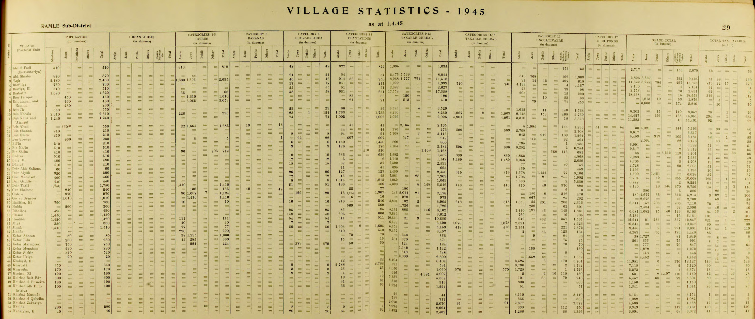
In the 1945 statistics the village had 4,538 dunams of land.[2][3] Of this, a total of 2,161 dunams were used for cereals,[11] while 2,377 dunams were classified as non-cultivable areas.[12]
Khirbat Zakariyya was destroyed with the exception of its well. A shrine was also located to the south of the village center.
1948, aftermath
Khirbat Zakariyya became depopulated on July 12-13, 1948, after a military assault by Israeli forces.[4][13][14][15][16]
The Israeli settlement of Mevo Modi'im was established in 1964 just northeast of Khirbat Zakariyya land.[17]
References
- ↑ Palmer, 1881, p. 240
- 1 2 Department of Statistics, 1945, p. 29
- 1 2 Government of Palestine, Department of Statistics. Village Statistics, April, 1945. Quoted in Hadawi, 1970, p. 67
- 1 2 Morris, 2004, p. xix village #231. Also gives causes of depopulation.
- ↑ Shachar, 2017, Horbat Zekharya
- ↑ Guérin, 1875, pp. p. 53
- ↑ Clermont-Ganneau, 1896, pp. 354-358; 478
- ↑ Conder and Kitchener, 1882, SWP II, p. 336
- ↑ Conder and Kitchener, 1882, SWP II, p. 358
- ↑ Conder and Kitchener, 1882, SWP II, p. 321
- ↑ Government of Palestine, Department of Statistics. Village Statistics, April, 1945. Quoted in Hadawi, 1970, p. 116
- ↑ Government of Palestine, Department of Statistics. Village Statistics, April, 1945. Quoted in Hadawi, 1970, p. 166
- ↑ Morris, 2004, p. 354
- ↑ Morris, 2004, p. 376
- ↑ Morris, 2004, p. 433
- ↑ Morris, 2004, p. 435
- ↑ Khalidi, 1992, p. 424
Bibliography
- Clermont-Ganneau, C.S. (1896). [ARP] Archaeological Researches in Palestine 1873-1874, translated from the French by J. McFarlane. 2. London: Palestine Exploration Fund.
- Conder, C.R.; Kitchener, H. H. (1882). The Survey of Western Palestine: Memoirs of the Topography, Orography, Hydrography, and Archaeology. 2. London: Committee of the Palestine Exploration Fund.
- Department of Statistics (1945). Village Statistics, April, 1945. Government of Palestine.
- Guérin, V. (1875). Description Géographique Historique et Archéologique de la Palestine (in French). 2: Samarie, pt. 2. Paris: L'Imprimerie Nationale.
- Hadawi, S. (1970). Village Statistics of 1945: A Classification of Land and Area ownership in Palestine. Palestine Liberation Organization Research Center.
- Khalidi, W. (1992). All That Remains: The Palestinian Villages Occupied and Depopulated by Israel in 1948. Washington D.C.: Institute for Palestine Studies. ISBN 0-88728-224-5.
- Morris, B. (2004). The Birth of the Palestinian Refugee Problem Revisited. Cambridge University Press. ISBN 978-0-521-00967-6.
- Palmer, E. H. (1881). The Survey of Western Palestine: Arabic and English Name Lists Collected During the Survey by Lieutenants Conder and Kitchener, R. E. Transliterated and Explained by E.H. Palmer. Committee of the Palestine Exploration Fund.
- Shachar, Dan (2017-12-03). "Horbat Zekharya" (129). Hadashot Arkheologiyot – Excavations and Surveys in Israel.
External links
- Welcome To Zakariyya, Khirbat
- Khirbat Zakariyya, Zochrot
- Survey of Western Palestine, Map 14: IAA, Wikimedia commons