Tel Afek
| תל אפק | |
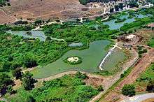 Ein Afek Aerial photo | |
 Shown within Israel | |
| Alternative name | Apheq |
|---|---|
| Location |
|
| Coordinates | 32°50′46″N 35°06′43″E / 32.846072°N 35.111969°E |
| Grid position | 160/250 PAL |
| History | |
| Periods | Middle Bronze Age - Crusader period |
| Official name | En Afeq Nature Reserve |
| Designated | 12 November 1996 |
| Reference no. | 867[1] |


Tel Afek, (Hebrew: תל אפק), also spelled Aphek and Afeq, is an archaeological site located in the coastal hinterland of the Ein Afek Nature Reserve, east of Kiryat Bialik, Israel. It is also known as Tel Kurdani.[2]
History
The site is what remains of the biblical town of Aphik, which is mentioned in the Joshua 19:30 and Judges 1:31 as belonging to the Tribe of Asher.[3][4] According to Biblical history, this area was part of Cabul and was given to Hiram I by Solomon as a reward for various services rendered to him in building the First Temple. 1 Kings 9:12.[5]
Remains from the Chalcolithic age, and tombs from the Middle Bronze Age and Late Bronze Ages have been excavated here.[6]
Pottery from the Persian,[7] Hellenistic[6][7] Roman,[7] and the Byzantine eras have been found here.[7]
Crusader/Mamluk era
Pottery from the Crusader times have been found here.[7] In the Crusader era, it was known as Recordane, and in 1154, the mill and village was acquired the Hospitalliers.[8] The Hospitalliers owned the water mills here for a number of years.[9] Between 1235 and 1262 the Hospitalliers had a dispute with the Templars about water rights.[10]
Two aqueducts, dating from this era, have been excavated.[6]
In 1283 it was still part of the Crusader states, as it was mentioned as part of their domain in the hudna between the Crusaders based in Acre and the Mamluk sultan Qalawun.[11][12]
According to al-Maqrizi, it had come under Mamluk rule in 1291, when it was mentioned under the name of Kerdanah when sultan al-Ashraf Khalil allocated the village's income to a waqf in Cairo.[13][14]
A two-story fortress still stands. A water-powered flour mill operated on the lower floor.[15]
Ottoman era
Incorporated into the Ottoman Empire in 1517, it appeared under the name Kufrdani in the census of 1596, located in the Nahiya of Acca of the Liwa of Safad. The village was noted as "hali" (empty), but taxes were paid, a total of 1,800 akçe. All of the revenues went to a waqf.[16][17] The stair to the tower roof of the mill, and two more wheel-chambers in the southern part of the mill was added in the Ottoman period.[15]
In 1881, the Palestine Exploration Fund's Survey of Western Palestine (SWP) found at Kh. Khurdaneh (east of the mill) only heaps of stones.[18] The name, Kh. Kurdâneh was taken to mean the ruin of Kurdâneh, p.n. [19]
In 1900, Gottlieb Schumacher found here markings on the mill which he took to be Phoenician.[20]
British Mandate era
In 1925 a Zionist organisation purchased 1,500 dunums in Kordaneh, from Alfred Sursuk, of the Sursuk family of Beirut. At the time, there were 20 families living there.[21]
In the 1931 census of Palestine, Mathanat Kurdani was counted under Shefa-'Amr.[22]
Ein Afek nature reserve
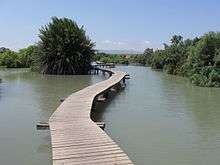
The Ein Afek nature reserve, declared in 1979, covers 366 dunams. An additional 300 dunams were declared in 1994.[23] The highlights of the park include the Crusader fortress and the natural water canals and lake, which draw their waters from the year-long flowing springs of Afek, which are the source of the Naaman river.[5]
See also
References
- ↑ "En Afeq Nature Reserve". Ramsar Sites Information Service. Retrieved 25 April 2018.
- ↑ Avner Kessler and Uri Kafri (2007). "Application of a cell model for operational management of the Na'aman groundwater basin, Israel". Israel Journal of Earth Sciences. 56: 29–46. doi:10.1560/ijes.56.1.29.
- ↑ Oxford Bible Atlas By Adrian Curtis, page 206
- ↑ The Land of the Bible: A Historical Geography, By Yohanan Aharoni, page 430
- 1 2 "Ein Afek nature reserve" (PDF). Israel Parks and Nature Authority.
- 1 2 3 Porat, 2010, Tel Afeq (East)
- 1 2 3 4 5 Abu Raya and Porat, 2012, Tel Afeq (Northeast)
- ↑ Röhricht, 1893, RRH No 293; cited in Pringle, 1997, p. 64
- ↑ Röhricht, 1893, RRH No 293; RRH No 1062; RRH Ad No 1319a; RRH No 1322; all cited in Frankel, 1988, p. 261
- ↑ Pringle, 1997, p. 64
- ↑ The al-Qalqashandi version of the hudna, referred in Barag, 1979, p. 205, #28
- ↑ Khamisy, 2013, p. 94, #37
- ↑ al-Maqrizi, 1845, vol 2, p. 131
- ↑ Barag, 1979, p. 203
- 1 2 Pringle, 1997, pp. 62-64
- ↑ Hütteroth and Abdulfattah, 1977, p. 192
- ↑ Note that Rhode, 1979, p. 6 writes that the Safad register that Hütteroth and Abdulfattah studied was not from 1595/6, but from 1548/9.
- ↑ Conder and Kitchener, 1881, SWP I, p. 314
- ↑ Palmer, 1881, p. 112
- ↑ Schumacher, 1900, p. 360
- ↑ List of villages sold by Sursocks and their partners to the Zionists since British occupation of Palestine, evidence to the Shaw Commission, 1930
- ↑ Mills, 1932, p. 96 (PDF)
- ↑ "List of National Parks and Nature Reserves" (PDF) (in Hebrew). Israel Nature and Parks Authority. Retrieved February 8, 2011.
Bibliography
- Abu Raya, Rafeh; Porat, Leea (2012-09-19). "Tel Afeq (Northeast)". 124. Hadashot Arkheologiyot – Excavations and Surveys in Israel.
- Accos, Iris (2000). "Tel Afek" (112). Hadashot Arkheologiyot – Excavations and Surveys in Israel.
- Al-Maqrizi (1845). Histoire des sultans mamlouks, de l'Égypte, écrite en arabe (in French and Latin). 2. Translator: Étienne Marc Quatremère. Paris: Oriental Translation Fund of Great Britain and Ireland.
- Barag, Dan (1979). "A new source concerning the ultimate borders of the Latin Kingdom of Jerusalem". Israel Exploration Journal. 29: 197–217. JSTOR 27925726.
- Conder, C.R.; Kitchener, H.H. (1881). The Survey of Western Palestine: Memoirs of the Topography, Orography, Hydrography, and Archaeology. 1. London: Committee of the Palestine Exploration Fund.
- Frankel, Rafael (1988). "Topographical notes on the territory of Acre in the Crusader period". Israel Exploration Journal. 38 (4): 249–272.
- Hütteroth, Wolf-Dieter; Abdulfattah, Kamal (1977). Historical Geography of Palestine, Transjordan and Southern Syria in the Late 16th Century. Erlanger Geographische Arbeiten, Sonderband 5. Erlangen, Germany: Vorstand der Fränkischen Geographischen Gesellschaft. ISBN 3-920405-41-2.
- Khamisy, Rabei G. (2014). "The Treaty of 1283 between Sultan Qalāwūn and the Frankish Authorities of Acre: A New Topographical Discussion". Israel Exploration Journal. 64, 1: 72–102.
- Mills, E., ed. (1932). Census of Palestine 1931. Population of Villages, Towns and Administrative Areas. Jerusalem: Government of Palestine.
- Ornan, Tallay, 2007, "Labor Pangs: The Revadim Plaque Type", in Bickel, S., Schroer, S. and Uehlinger, Ch. (eds.), Bilder als Quellen / Images as Sources. Studies on Ancient Near Eastern Artefacts and the Bible inspired by the work of Othmar Keel, OBO Special Volume, Fribourg and Göttingen, 2007, pp. 215–235, pl.XXIV. ISBN 978-3-7278-1613-0
- Palmer, E.H. (1881). The Survey of Western Palestine: Arabic and English Name Lists Collected During the Survey by Lieutenants Conder and Kitchener, R. E. Transliterated and Explained by E.H. Palmer. Committee of the Palestine Exploration Fund.
- Porat, Leea (2010-12-26). "Tel Afeq (East)". 122. Hadashot Arkheologiyot – Excavations and Surveys in Israel.
- Pringle, Denys (1997). Secular buildings in the Crusader Kingdom of Jerusalem: an archaeological Gazetter. Cambridge University Press. ISBN 0521 46010 7.
- Rhode, H. (1979). Administration and Population of the Sancak of Safed in the Sixteenth Century. Columbia University.
- Röhricht, R. (1893). (RRH) Regesta regni Hierosolymitani (MXCVII-MCCXCI) (in Latin). Berlin: Libraria Academica Wageriana.
- Röhricht, R. (1904). (RRH Ad) Regesta regni Hierosolymitani Additamentum (in Latin). Berlin: Libraria Academica Wageriana.
- Schumacher, G. (1900). "Tell el Kurdaneh". Quarterly statement - Palestine Exploration Fund. 32: 360.
- Thomson, W.M. (1859). The Land and the Book: Or, Biblical Illustrations Drawn from the Manners and Customs, the Scenes and Scenery, of the Holy Land. 1 (1 ed.). New York: Harper & brothers. (p. 486)
- Warren, Peter M.; Hankey, V. (1989). Aegean Bronze Age Chronology. Bristol Classical Press. ISBN 090651567X.
External links
- Survey of Western Palestine, Map 5: IAA, Wikimedia commons
| Northern District |
|
|---|---|
| Central District |
|
| Southern District | |
| Eilat Region | |
† Located in the Israeli-occupied territories | |
| |||||
| |||||