Bayt Daras
| Bayt Daras | |
|---|---|
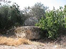 Old structure from Bayt Daras, presently in Azrikam | |
 Bayt Daras | |
| Arabic | بيت دراس |
| Name meaning | "The house of treading corn"[1] |
| Also spelled | Beit Daras, Baydarās-Badarās, Dāris[2] Bethduras[3] |
| Subdistrict | Gaza |
| Coordinates | 31°43′24″N 34°40′58″E / 31.72333°N 34.68278°ECoordinates: 31°43′24″N 34°40′58″E / 31.72333°N 34.68278°E |
| Palestine grid | 120/125 |
| Population | 2,750[4][5] (1945) |
| Area |
16,357[5] dunams 16.3 km² |
| Date of depopulation | May 11, 1948[6] |
| Cause(s) of depopulation | Military assault by Yishuv forces |
| Current localities | Giv'ati[7][8] Emunim[8] Azrikam[8] |
Bayt Daras (Arabic: بيت دراس) was a Palestinian Arab town located 32 kilometers (20 mi) northeast of Gaza and approximately 50 meters (160 ft) above sea level, which was depopulated in 1948.[8]
History
Bayt Daras was an archaeological site that contained stone foundations and vaulted rooms. The Crusaders built a castle on the hill that overlooked the village.[8][9][10] During the Mamluk rule in Palestine, (1205-1517), Bayt Daras formed part of a mail route from Cairo to Damascus. In this period, in 1325, a khan, or caravanserai, was built in the village.[2][8]
Ottoman era
In 1517, Bayt Daras was incorporated into the Ottoman Empire with the rest of Palestine, and in 1596 the village appeared in the Ottoman tax registers as being in the nahiya (subdistrict) of Gaza under the Liwa of Gaza, with a population of 58 Muslim households; an estimated 319 persons. It paid a fixed tax rate of 33,3% on a number of crops, including wheat and barley, as well as on goats, beehives and vineyards; a total of 7,900 akçe. 1/24 of the revenue went to a waqf.[11]
French explorer Victor Guérin visited the village in 1863, and found it to have 700 inhabitants.[12] In the 1882 Palestine Exploration Fund's Survey of Western Palestine (SWP), the village of Bayt Daras was described as being surrounded by gardens and olive groves, and it was bordered to the north by a pond.[13]
British Mandate era
In the 1922 census of Palestine, conducted by the British Mandate authorities, Bait Daras had a population of 1,670 Muslims,[14] increasing in the 1931 census of Palestine, to 1,804, still all Muslim, in 401 inhabited houses.[15]
In the 1945 statistics Beit Daras had a population of 2,750 Muslims,[4] with 16,357 dunams of land, according to an official land and population survey.[5] Of this, 832 dunams were allocated to citrus and banana plants, 472 plantations and irrigable land, 14,436 used for cereals,[16] while 88 dunams were built-up land.[17]
1948 War and aftermath
In response to hundreds of fighters from Bayt Daras attacking Kibbutz Nitzanim[18], the village was subject to an Israeli counteroffensive military assault four times,[19]. It was defended by the Sudanese Army and a number of local militiamen and, according to Ramzy Baroud, subjected to heavy shelling on March 27–28, 1948, in which nine villagers died and much of the crops were destroyed.[20][21] The objective of the Palmach's operational plan, 'Operation Lightning' (Mivtza Barak) was to compel the Arab inhabitants of the area to 'move' and by striking one or more population centres to cause an exodus, which was foreseen given the wave of panic that was sweeping Arab communities after the Deir Yassin massacre.[20] Bayt Daras was targeted to be surrounded, to have the villagers surrender and hand over their arms, and if this order was resisted, it was to be mortared, stormed and 'dealt with in the manner of scorched earth'. It was finally captured by military assault on May 11, 1948 by the Givati Brigade during Operation Barak, just prior to the outbreak of the 1948 Arab–Israeli War.[22] The village suffered some 50 casualties, and many houses were then blown up, and wells and granaries sabotaged.[23] Bayt Daras had a population of 3,190 living in 709 houses in 1948. In Baroud's account, a massacre took place as people fled the village.[20]
According to the memoirs of Gamal Abdel Nasser, the empty village was reoccupied by Sudanese forces in June, but they left after a signaling error caused them to be shelled by their own side.[24]
Structures in the village were made of stone foundations with vaulted rooms. There were also two elementary schools and two mosques, all of which were demolished after its capture.
Following the war the area was incorporated into the State of Israel. In 1950 the moshav of Giv'ati was built on the site of the village, with two other moshavim, Azrikam, Emunim, established on land that had belonged to Bayt Daras.[8] Later in the 1950s a farm called Zemorot was built on Khirbat Awda, which had also belonged to Bayt Daras.[25]
In 1992 the village site was described: "The only remain of village buildings are the foundations of one house and some scattered rubble. The site is overgrown with wild vegetation interspersed by cactuses and eucalyptus trees. At least one of the streets is clearly recognisable. The surrounding fields are cultivated by the settlements."[25]
Culture
A woman's thob (loose fitting robe with sleeves) dated to about 1930 from the village of Beit Daras is part of the Museum of International Folk Art (MOIFA) collection at Santa Fe. The dress fabric is called abu hizz ahmar (black cotton ground with purple, orange and green stipes of cotton and silk), from Majdal. The only embroidery on the front is below the neck opening. The back panel has three horizontal bands of embroidery, and a local version of the khem-el-basha ("the pashas tent") motif along the hem.[26]
See also
References
- ↑ Palmer, 1881, p. 266
- 1 2 Sharon, 1999, p. 229
- ↑ Ellenblum, 2003, p. XX
- 1 2 Government of Palestine, Department of Statistics, 1945, p. 31
- 1 2 3 Government of Palestine, Department of Statistics. Village Statistics, April, 1945. Quoted in Hadawi, 1970, p. 45
- ↑ Morris, 2004, p. xix, village #282, Also gives cause of depopulation.
- ↑ Morris, 2004, p.xxi, settlement #65, 1949-1950
- 1 2 3 4 5 6 7 Khalidi, 1992, p. 87
- ↑ 545, 546 in 1177 CE, in Röhricht, 1893, p. 145
- ↑ Ellenblum, 2003, p. 202
- ↑ Hütteroth and Abdulfattah, 1977, p. 146. Quoted and estimated in Khalidi, 1992, p. 87
- ↑ Guérin, 1869, p. 81
- ↑ Conder and Kitchener, 1882, II:409. Also quoted in Khalidi, 1992, p.87
- ↑ Barron, 1923, Table V, Sub-district of Gaza, p. 8
- ↑ Mills, 1932, p. 2
- ↑ Government of Palestine, Department of Statistics. Village Statistics, April, 1945. Quoted in Hadawi, 1970, p. 86
- ↑ Government of Palestine, Department of Statistics. Village Statistics, April, 1945. Quoted in Hadawi, 1970, p. 136
- ↑ Wallach, J., ed. (2003). Battle Sites in Israel (English title) (in Hebrew). Jerusalem, Israel: Carta. pp. 188–189. ISBN 965-220-494-3.
- ↑ S.A. Jawad, 'Zionist Massacres: the creation of the Palestine Refugee Problem,' in Eyal Benvenisti, Chaim Gans, Sari Hanafi (eds.) Israel and the Palestinian Refugees, Springer 2007 pp.59-127 p.81 n.60.
- 1 2 3 Ramzy Baroud, 'Beit Daras and a buried history of massacres,', in Asia Times, 16 April 2013.
- ↑ My Father Was a Freedom Fighter: Gaza’s Untold Story, Pluto Press, 2010
- ↑ Morris, 2004, pp. 256-257
- ↑ Morris, 2004, p. 256
- ↑ Gamal Abdul Nasser and Walid Khalidi (1973). "Nasser's Memoirs of the First Palestine War". Journal of Palestine Studies. 2 (2): 3–32. doi:10.1525/jps.1973.2.2.00p0045r.
- 1 2 Khalidi, 1992, p. 88
- ↑ Stillman, 1979, p. 76
Bibliography
- Barron, J.B., ed. (1923). Palestine: Report and General Abstracts of the Census of 1922. Government of Palestine.
- Conder, C.R.; Kitchener, H.H. (1882). The Survey of Western Palestine: Memoirs of the Topography, Orography, Hydrography, and Archaeology. 2. London: Committee of the Palestine Exploration Fund.
- Ellenblum, Ronnie (2003). Frankish Rural Settlement in the Latin Kingdom of Jerusalem. Cambridge University Press. ISBN 9780521521871.
- Government of Palestine, Department of Statistics (1945). Village Statistics, April, 1945.
- Guérin, V. (1869). Description Géographique Historique et Archéologique de la Palestine (in French). 1: Judee, pt. 2. Paris: L'Imprimerie Nationale.
- Hadawi, S. (1970). Village Statistics of 1945: A Classification of Land and Area ownership in Palestine. Palestine Liberation Organization Research Center.
- Hütteroth, Wolf-Dieter; Abdulfattah, Kamal (1977). Historical Geography of Palestine, Transjordan and Southern Syria in the Late 16th Century. Erlanger Geographische Arbeiten, Sonderband 5. Erlangen, Germany: Vorstand der Fränkischen Geographischen Gesellschaft. ISBN 3-920405-41-2.
- Khalidi, W. (1992). All That Remains: The Palestinian Villages Occupied and Depopulated by Israel in 1948. Washington D.C.: Institute for Palestine Studies. ISBN 0-88728-224-5.
- Mills, E., ed. (1932). Census of Palestine 1931. Population of Villages, Towns and Administrative Areas. Jerusalem: Government of Palestine.
- Morris, B. (2004). The Birth of the Palestinian Refugee Problem Revisited. Cambridge University Press. ISBN 978-0-521-00967-6.
- Nasser, G.A. (1955/1973): "Memoirs" in Journal of Palestine Studies
- “Nasser's Memoirs of the First Palestine War” in 2, no. 2 (Win. 73): 3-32, pdf-file, downloadable
- Palmer, E.H. (1881). The Survey of Western Palestine: Arabic and English Name Lists Collected During the Survey by Lieutenants Conder and Kitchener, R. E. Transliterated and Explained by E.H. Palmer. Committee of the Palestine Exploration Fund.
- Röhricht, R. (1893). (RRH) Regesta regni Hierosolymitani (MXCVII-MCCXCI) (in Latin). Berlin: Libraria Academica Wageriana.
- Sharon, M. (1999). Corpus Inscriptionum Arabicarum Palaestinae, B-C. 2. BRILL. ISBN 90-04-11083-6.
- Stillman, Yedida Kalfon (1979): Palestinian costume and jewelry, Albuquerque: University of New Mexico Press, ISBN 0-8263-0490-7 (A catalog of the Museum of International Folk Art (MOIFA) at Santa Fe's collection of Palestinian clothing and jewelry.)
External links
- Welcome to Bayt Daras Palestine Remembered
- Bayt Daras, Zochrot
- Survey of Western Palestine, Map 16: IAA, Wikimedia commons
- Dome structure in ‘Azrikam
- Bayt Daras from the Khalil Sakakini Cultural Center