Taibe, Galilee
| Taibe טַּיִּבָּה لطيبة | |
|---|---|
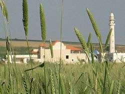
 Taibe, 2010 | |
 Taibe | |
| Coordinates: 32°36′N 35°26′E / 32.600°N 35.433°ECoordinates: 32°36′N 35°26′E / 32.600°N 35.433°E | |
| Grid position | 192/223 PAL |
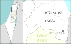
| District | Northern |
| Council | Gilboa |
| Population (2017)[1] | 1,810 |
Taibe (Arabic: الطيبة; Hebrew: טַּיִּבָּה), meaning "The goodly",[2] is a Muslim Arab village in northeastern Israel. Located in the Jezreel Valley, it falls under the jurisdiction of Gilboa Regional Council. In 2017 it had a population of 1,810.[1]
History
It has been proposed that Taibe was Tubi, listed among the places paying tribute to Thutmose III.[3] Historical geographer Yeshayahu Press thought the site to be the biblical Hapharaim mentioned in Joshua 19:19 in connection with the tribe of Issachar, by a reversion of its name from what sounded like Afrin ("demons") to a euphemistic sound (lit. "the goodly"), as was common in other Arabic place-names.[4] Remains from the Hellenistic, Roman, Byzantine, Crusader, and Mamluk periods have been found.[5][6] North east of the village sarcophagus remains have been found. This area apparently functioned as a graveyard during the Roman and Byzantine eras.[7]
During the Crusader period there was a castle here called (Le) Forbelet (in medieval Arabic: 'Afrabala).[8] It was probably Hospitaller and dependent on nearby Belvoir.[8] Yaqut (1179–1229) noted about the village, which he called Afrabala: "A place in the Jordan Ghaur (or low-land), near Baisan and Tabariyyah."[9]
In July 1182 the castle was the background of the pitched large-scale Battle of Forbelet between Baldwin IV and Saladin.[10] The castle was sacked by Saladin in 1183, and occupied by the Muslims besieging Belvoir in 1187-88.[8] Parts of the castle keep's basement still survive, as do other installations from the Crusader Period.[5][8] Recent excavations indicate that new buildings were constructed alongside the partially destroyed Crusader castle in Mamluk and Ottoman times.[11]
Ottoman era
Taibe was incorporated into the Ottoman Empire in 1517 with all of Palestine, and in 1596 it appeared in the tax registers under the name of Tayyibat al-Ism as being in the Nahiya of Shafa of the Liwa of Lajjun. It had a population of 13 Muslim households and paid taxes on wheat, barley, summer crops, and goats or beehives; a total of 5,300 Akçe.[12] Pierre Jacotin named the village Taibeh on his map from 1799.[13]
In 1875, the French explorer Victor Guérin visited the village and described it as poor, but formerly an important city,[14] while in 1882 the Palestine Exploration Fund's Survey of Western Palestine described Taibe as: "A straggling village, of moderate size, lying on flat ground, and containing several good stone houses. There is one in the middle of the village, belonging to the Sheikh, which is larger than the rest."[3]
British Mandate era

In a census conducted in 1922 by the British Mandate authorities, Taibeh had a population of 220, all Muslim,[15] while at the time of the 1931 census, At-Taiyiba had 43 occupied houses and a population of 186 Muslims.[16]
In the 1945 statistics Taibe had a population of 280 Muslims (counted with 150 Jews at Moledet)[17] with 7,127 dunams of land, according to an official land and population survey.[18] Of this, 7,103 dunams were used for cereals,[19] while 22 dunams were built-up land.[20]
State of Israel
Since 1948 Taibe has been under Israeli rule. To mark Israel's 60th anniversary in 2008, the dome of the local mosque was painted in the Israeli colors, blue and white.[21][22]
Nearly all the residents of Taibe are members of the Zuabi family, one of the larger clans in Israel.[23]
See also
References
- 1 2 "List of localities, in Alphabetical order" (PDF). Israel Central Bureau of Statistics. Retrieved August 26, 2018.
- ↑ Palmer, 1881, p.167
- 1 2 Conder and Kitchener, 1882, SWP II, p. 87
- ↑ Ishtori Haparchi, Kaftor u'ferach vol. 2, (3rd edition, published by ed. Avraham Yosef Havatzelet), chapter 11, Jerusalem 2007, p. 63 (note 144) (Hebrew)
- 1 2 Covello-Paran and Tepper, 2008, Et-Taiyiba
- ↑ Tepper, 2012, E-Taiyiba, Survey Final Report
- ↑ Mokary, 2017, Et-Taiyiba, Horbat Haddad
- 1 2 3 4 Pringle, 1997, p. 104
- ↑ le Strange, 1890, p. 385
- ↑ Corliss K. Slack (2013). Historical Dictionary of the Crusades. Plymouth: Scarecrow Press of Rowman & Littlefield. p. 51. ISBN 978-0-8108-7830-3. Retrieved 2 January 2015.
- ↑ Abu Zidan, 2011, Et-Taiyiba Final Report
- ↑ Hütteroth and Abdulfattah, 1977, p. 157
- ↑ Karmon, 1960, p. 169
- ↑ Guérin, 1880, pp. 126–127 as translated by Conder and Kitchener, 1882, SWP II, pp. 126 -127: "This village, poor and miserable, is now nothing but a wretched relic of an important city, situated on the slope of a hill whose summit was surrounded by a fortress. This was formerly constructed of very fine basaltic blocks, cut and dressed with care ; a ditch cut in the rock and now three-fourths filled up surrounded it, at least on the south and west. There remain of this stronghold several thick parts of the wall, and within vaulted magazines which now serve the fellahin for refuge : rude dwelling-houses have also been built within the inclosure. One of these houses, more considerable than the others, and partly constructed of good basaltic stones taken from the ruins of the fort, occupies the top of the acropolis, which I regard as ancient, although allowing that it may have received attention from the Mohammedans or the Crusaders. As for the city, which extended to the north and east of the castle, it now, with the exception of a few courses still upright, presents nothing but a heap of ruins.'
- ↑ Barron, 1923, Table IX, Sub-district of Baisan, p. 31
- ↑ Mills, 1932, p. 81
- ↑ Department of Statistics, 1945, p. 7
- ↑ Government of Palestine, Department of Statistics. Village Statistics, April, 1945. Quoted in Hadawi, 1970, p. 44
- ↑ Government of Palestine, Department of Statistics. Village Statistics, April, 1945. Quoted in Hadawi, 1970, p. 85
- ↑ Government of Palestine, Department of Statistics. Village Statistics, April, 1945. Quoted in Hadawi, 1970, p. 135
- ↑ "Galilee Arabs paint mosque blue and white for Israel's 60th". Haaretz. 12 January 2011. Retrieved 27 November 2011.
- ↑ Dudu Bazak (4 July 2008). "Identifying with the country: The mosque was painted blue and white". Maariv. Retrieved 27 November 2011.
- ↑ Arab villagers in A-Taibeh struggle to be accepted as Israelis Haaretz, 12 January 2011
Bibliography
- Abu Zidan, Fadi (2011-05-01). "Et-Taiyiba Final Report" (123). Hadashot Arkheologiyot – Excavations and Surveys in Israel.
- Atrash, Walid (2015-02-26). "Et-Taiyiba Final Report" (127). Hadashot Arkheologiyot – Excavations and Surveys in Israel.
- Barron, J. B., ed. (1923). Palestine: Report and General Abstracts of the Census of 1922. Government of Palestine.
- Conder, C.R.; Kitchener, H.H. (1882). The Survey of Western Palestine: Memoirs of the Topography, Orography, Hydrography, and Archaeology. 2. London: Committee of the Palestine Exploration Fund.
- Covello-Paran, Karen; Tepper, Yotam (2008-08-24). "Et-Taiyiba Final Report" (120). Hadashot Arkheologiyot – Excavations and Surveys in Israel.
- Dalali-Amos, Edna (2016-07-12). "Et-Taiyiba Final Report" (128). Hadashot Arkheologiyot – Excavations and Surveys in Israel.
- Department of Statistics (1945). Village Statistics, April, 1945. Government of Palestine.
- Guérin, V. (1880). Description Géographique Historique et Archéologique de la Palestine (in French). 3: Galilee, pt. 1. Paris: L'Imprimerie Nationale.
- Hadawi, S. (1970). Village Statistics of 1945: A Classification of Land and Area ownership in Palestine. Palestine Liberation Organization Research Center.
- Hütteroth, Wolf-Dieter; Abdulfattah, Kamal (1977). Historical Geography of Palestine, Transjordan and Southern Syria in the Late 16th Century. Erlanger Geographische Arbeiten, Sonderband 5. Erlangen, Germany: Vorstand der Fränkischen Geographischen Gesellschaft. ISBN 3-920405-41-2.
- Karmon, Y. (1960). "An Analysis of Jacotin's Map of Palestine" (PDF). Israel Exploration Journal. 10 (3, 4): 155–173, 244–253.
- Mills, E., ed. (1932). Census of Palestine 1931. Population of Villages, Towns and Administrative Areas. Jerusalem: Government of Palestine.
- Mokary, Abdalla (2017-06-19). "Et-Taiyiba, Horbat Haddad" (129). Hadashot Arkheologiyot – Excavations and Surveys in Israel.
- Palmer, E.H. (1881). The Survey of Western Palestine: Arabic and English Name Lists Collected During the Survey by Lieutenants Conder and Kitchener, R. E. Transliterated and Explained by E.H. Palmer. Committee of the Palestine Exploration Fund.
- RHC Or vol. 4, 1898, Recueil des historiens des croisades (p. 345, cf p. 303)
- Pringle, Denys (1997). Secular buildings in the Crusader Kingdom of Jerusalem: an archaeological Gazetter. Cambridge University Press.
- Strange, le, G. (1890). Palestine Under the Moslems: A Description of Syria and the Holy Land from A.D. 650 to 1500. Committee of the Palestine Exploration Fund.
- Tepper, Y. (2012-04-16). "Et-Taiyiba, Survey, Final Report" (124). Hadashot Arkheologiyot – Excavations and Surveys in Israel.
- Tepper, Y.; Covello-Paran, Karen (2012-12-31). "Et-Taiyiba Final Report" (124). Hadashot Arkheologiyot – Excavations and Surveys in Israel.
External links
- Welcome To Kh. al-Tayiba
- Survey of Western Palestine, Map 9: IAA, Wikimedia commons, where it is listed as et Taiyibeh
| |||||
| |||||