Qalunya
| Qalunya | |
|---|---|
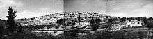
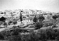 Qalunya, before 1949 | |
 Qalunya | |
| Arabic | قالونيا |
| Name meaning | from the Latin Colonia[1] |
| Also spelled | Qaluniya, Colonia, Kolonia |
| Subdistrict | Jerusalem |
| Coordinates | 31°47′39″N 35°9′27″E / 31.79417°N 35.15750°ECoordinates: 31°47′39″N 35°9′27″E / 31.79417°N 35.15750°E |
| Palestine grid | 165/133 |
| Population | 900[2][3] (1945) |
| Area | 4,844[2][3] dunams |
| Date of depopulation | early April, 1948,[4] |
| Cause(s) of depopulation | Military assault by Yishuv forces |
| Current localities | Mevaseret Zion |
Qalunya (Arabic: قالونيا, also transliterated Qaluniya, Colonia and Kolonia) was a Palestinian Arab village located 6 kilometers (3.7 mi) west of Jerusalem.[5]
Prior to the village's destruction in 1948, with the exception of 166 dunams, Qalunya's land was privately owned: 3,594 dunams were owned by Arabs, while 1,084 dunams were owned by Jews.[2][3]
Location
Qalunya stood on a mountain slope, facing southwest; Wadi Qalunya passed through its eastern edge. The village lay on the Jerusalem-Jaffa highway, and a dirt path linked it to its neighboring villages.[6] Qalunya was located near the Jewish town of Motza. Motza is now an outlying neighborhood of Jerusalem, and ruins of demolished buildings from Qalunya are present near Motza, covered in vegetation, just off the main highway between Jerusalem and Tel Aviv. The town of Mevaseret Zion today is expanding upon some of the territory of former Qalunya.
History
Bronze Age to Roman era
Qalunya is identified with the Canaanite and later Israelite town of Mozah,[7] which according to the Hebrew Bible was allotted by Joshua to the Tribe of Benjamin (Joshua 18:26). Its name was found stamped on pottery handles in Tell en-Nasbeh.[8] During the First and Second Temple periods Mozah was a Jewish village known for its willows,[9] whose branches were used at the Temple in Jerusalem.
In 2012 Israeli archaeologists discovered the Tel Motza temple, an Israelite cultic building dating to the monarchic period (Iron Age IIA).[10]
Roman and Byzantine periods
The village was destroyed in the First Jewish–Roman War. After A.D. 71 Vespasian settled 800 Roman soldiers in the town, which became a Roman settlement known as Colonia Amosa or Colonia Emmaus.[6]
The word colonia produced the Byzantine-period Greek name, Koloneia, for the site. The status of the site in the early Islamic period has not been established, but the name was preserved in Crusader times as Qalonie or Qalunia and in Arabic as Qalunya. Mujir al-Din al-Hanbali reported that in 1192 it was a village near Jerusalem.[11]
New Testament
It has also been suggested that Qalunya was Emmaus of the New Testament.[12] The site is at more or less the correct distance from Jerusalem to match the story told in the Gospel of Luke (Luke 24:13-35). The village where Vespasian settled the 800 veterans was known as Emmaus at that time. The new military colony completely eclipsed the title town and its name was lost to history. During the Byzantine period the name Emmaus was not in use, so the Byzantine Christians did not know of it. The tradition of Emmaus was attached to Emmaus-Nicopolis instead.[13] Excavations in 2001-2003 headed by Professor Carsten Peter Thiede let him conclude that Khirbet Mizza/Tel Moza was the only credible candidate for biblical Emmaus.[14]
Ottoman period
In the 1596 tax registers, Qalunya was a village in the Ottoman Empire, nahiya (subdistrict) of Jerusalem under the liwa' (district) of Jerusalem, and it had a population of 19 Muslim households, an estimated 110 persons. The villagers paid a fixed tax rate of 33,3% on a number of crops, including wheat, barley and olives, as well as on goats, beehives and molasses; a total of 6,450 akçe. All of the revenue went to Waqf.[16]
In 1838, Kulonieh was noted as a Muslim village in the Beni Malik district, west of Jerusalem.[17][18]
In 1863 Victor Guérin found it to be a village of 500 inhabitants,[19] while an Ottoman village list from about 1870 found that Kalonije had a population of 120, in 43 houses, though the population count included men, only.[20][21]
In 1883, the Palestine Exploration Fund's Survey of Western Palestine (SWP) described Qalunya as being a moderate-sized village perched on the slope of a hill, 300 feet (91 m) above a valley. Travelers reported that it had a "modern" restaurant. The villagers tended orange and lemon trees that were planted around a spring in the valley.[22] To the west of the restaurant were ruins, possible of Byzantine origin.[23]
In the 1890s, Jews purchased some of Qalunya's farmlands, and established the village of Motza, the first Jewish settlement outside Jerusalem.[24]
In 1896 the population of Kalonije was estimated to be about 312 persons.[25]
British Mandate
In the 1922 census of Palestine, conducted by the British Mandate authorities, Qalunieh (Qalonia) had a population 549; 456 Muslims, 88 Jews and 5 Orthodox Christians,[26][27] increasing in the 1931 census to 632, 632 Muslims and 10 Christians; in a total of 156 houses.[28]
During the 1929 Palestine riots, several residents of Qalunya attacked an outlying house in Motza belonging to the Maklef family, killing the father, mother, son, two daughters, and their two guests. Three children survived by escaping out a second-story window; one, Mordechai Maklef, later became Chief of Staff of the Israeli Army. The attackers included the lone police officer and armed man in the area, as well as a shepherd employed by the Maklef family. The village was subsequently abandoned by Jews for a year's time.[29]
In the 1945 statistics, Qalunya had a population of 900 Muslims and 10 Christians, while Motza had a population of 350 Jews.[2] The total land area was 4,844 dunams.[3] A total of 1,224 dunums of land were irrigated or used for plantations, 955 were used for cereals;[30] while 227 dunams were classified as built-up areas.[31]
1948, and after
On 11 April 1948, as part of Operation Nachshon, Hagana forces entered the village and blew up 50 houses.[32] According to Ilan Pappe, Qalunya was one of four villages that were systematically destroyed by Hagana units in this fashion in the immediate wake of the Deir Yassin massacre; the others being, Beit Surik, Biddu and Saris.[32]
References
- ↑ Palmer, 1881, p. 321
- 1 2 3 4 Department of Statistics, 1945, p. 25
- 1 2 3 4 Government of Palestine, Department of Statistics. Village Statistics, April, 1945. Quoted in Hadawi, 1970, p. 58
- ↑ Morris, 2004, p. xx, village #359. Also gives the cause of depopulation.
- ↑ "Qalunya". Palestine Remembered. Retrieved 2008-03-18.
- 1 2 Khalidi, 1992, p. 309
- ↑ Israel Finkelstein, Yuval Gadot, Mozah, Nephtoah and royal estates in the Jerusalem highlands, in Semitica et Cassica. International Journal of Oriental and Mediterranean Studies, Vol. VIII 2015, Brepols Publishers, pp. 227-8
- ↑ Nahman Avigad (1958). "New light on the MSH seal impressions". Israel Exploration Journal. 8: 117. Retrieved 25 May 2018 – via Israel Exploration Journal Reader, Volume 1, KTAV Publishing House, The Library of Biblical Studies, 1981, ISBN 9780870682674.
- ↑ Wheaton, Gerry (2015-02-26). The Role of Jewish Feasts in John's Gospel. Cambridge University Press. p. 140. ISBN 9781316299753.
- ↑ First Temple Period Ritual Structure Discovered Near Jerusalem
- ↑ Al:Khalidi 1968:181, Cited in Khalidi, 1992, p.309
- ↑ Conder and Kitchener, 1883, SWP III, p. 40
- ↑ Murphy-O'Connor, Jerome (2008). The Holy Land: An Oxford Archaeological Guide (5th ed.). Oxford, UK: Oxford University Press. pp. 362–363. ISBN 978-0-19-923666-4.
- ↑ Thiede, Carsten Peter (2005). "Die Wiederentdeckung von Emmaus bei Jerusalem" [Rediscovering Emmaus near Jerusalem]. Zeitschrift für antikes Christentum (in German). Walter de Gruyter. 8: 593–599. Retrieved 11 April 2015.
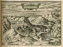
- ↑ Zuallart, 1587, p. 121
- ↑ Hütteroth and Abdulfattah, 1977, p. 118. Cited in Khalidi, 1992, p. 309
- ↑ Robinson and Smith, vol. 3, 2nd appendix, p. 123
- ↑ Robinson and Smith, vol. 2, p. 146
- ↑ Guérin, 1868, pp. 257-262
- ↑ Socin, 1879, p. 155 It was noted to be in the Bene Malik district
- ↑ Hartmann, 1883, p. 118, also noted 43 houses
- ↑ Conder and Kitchener, 1883, SWP III, p. 17. Quoted in Khalidi, 1992, p. 309
- ↑ Conder and Kitchener, 1883, SWP III, p. 132
- ↑ Ochs, Juliana (2011-06-06). Security and Suspicion: An Ethnography of Everyday Life in Israel. University of Pennsylvania Press. p. 31. ISBN 0812205685.
- ↑ Schick, 1896, p. 126
- ↑ Barron, 1923, Table VII, Sub-district of Jerusalem, p. 14
- ↑ Barron, 1923, Table XIV, p. 45
- ↑ Mills, 1932, p. 42
- ↑ Segev, 2013, p. 324
- ↑ Government of Palestine, Department of Statistics. Village Statistics, April, 1945. Quoted in Hadawi, 1970, p. 103
- ↑ Government of Palestine, Department of Statistics. Village Statistics, April, 1945. Quoted in Hadawi, 1970, p. 153
- 1 2 Pappe, 2006, p. 91.
Bibliography
- Barron, J. B., ed. (1923). Palestine: Report and General Abstracts of the Census of 1922. Government of Palestine.
- Conder, C.R.; Kitchener, H.H. (1883). The Survey of Western Palestine: Memoirs of the Topography, Orography, Hydrography, and Archaeology. 3. London: Committee of the Palestine Exploration Fund.
- Department of Statistics (1945). Village Statistics, April, 1945. Government of Palestine.
- Guérin, V. (1868). Description Géographique Historique et Archéologique de la Palestine (in French). 1: Judee, pt. 1. Paris: L'Imprimerie Nationale.
- Hadawi, S. (1970). Village Statistics of 1945: A Classification of Land and Area ownership in Palestine. Palestine Liberation Organization Research Center.
- Hartmann, M. (1883). "Die Ortschaftenliste des Liwa Jerusalem in dem türkischen Staatskalender für Syrien auf das Jahr 1288 der Flucht (1871)". Zeitschrift des Deutschen Palästina-Vereins. 6: 102–149.
- Hütteroth, Wolf-Dieter; Abdulfattah, Kamal (1977). Historical Geography of Palestine, Transjordan and Southern Syria in the Late 16th Century. Erlanger Geographische Arbeiten, Sonderband 5. Erlangen, Germany: Vorstand der Fränkischen Geographischen Gesellschaft. ISBN 3-920405-41-2.
- Khalidi, W. (1992). All That Remains: The Palestinian Villages Occupied and Depopulated by Israel in 1948. Washington D.C.: Institute for Palestine Studies. ISBN 0-88728-224-5.
- Mills, E., ed. (1932). Census of Palestine 1931. Population of Villages, Towns and Administrative Areas. Jerusalem: Government of Palestine.
- Morris, B. (2004). The Birth of the Palestinian Refugee Problem Revisited. Cambridge University Press. ISBN 978-0-521-00967-6.
- Palmer, E. H. (1881). The Survey of Western Palestine: Arabic and English Name Lists Collected During the Survey by Lieutenants Conder and Kitchener, R. E. Transliterated and Explained by E.H. Palmer. Committee of the Palestine Exploration Fund.
- Pappé, I. (2006). The Ethnic Cleansing of Palestine (Paperback 2008 ed.). Oneworld Publications Limited. ISBN 978-1-85168-555-4.
- Robinson, E.; Smith, E. (1841). Biblical Researches in Palestine, Mount Sinai and Arabia Petraea: A Journal of Travels in the year 1838. 2. Boston: Crocker & Brewster.
- Robinson, E.; Smith, E. (1841). Biblical Researches in Palestine, Mount Sinai and Arabia Petraea: A Journal of Travels in the year 1838. 3. Boston: Crocker & Brewster.
- Schick, C. (1896). "Zur Einwohnerzahl des Bezirks Jerusalem". Zeitschrift des Deutschen Palästina-Vereins. 19: 120–127.
- Segev, T. (2013). One Palestine, Complete. Macmillan. ISBN 1466843500.
- Socin, A. (1879). "Alphabetisches Verzeichniss von Ortschaften des Paschalik Jerusalem". Zeitschrift des Deutschen Palästina-Vereins. 2: 135–163.
- Zuallart, J. (1587). Il devotissimo viaggio di Gervsalemme. Roma.
External links
- Welcome To Qalunya
- Qalunya, Zochrot
- Survey of Western Palestine, Map 17: IAA, Wikimedia commons
- Qalunya, from the Khalil Sakakini Cultural Center