Khirbat Al-Burj
| Khirbat Al-Burj | |
|---|---|
 | |
 Khirbat Al-Burj | |
| Name meaning | The little tower[1] |
| Also spelled | Burj Binyamina |
| Subdistrict | Haifa |
| Coordinates | 32°30′41″N 34°56′34″E / 32.51139°N 34.94278°ECoordinates: 32°30′41″N 34°56′34″E / 32.51139°N 34.94278°E |
| Palestine grid | 144/212 |
| Current localities | Binyamina |
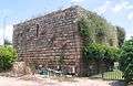
Khirbat Al-Burj or Burj Binyamina is a structure in the Sharon Plain 1 km south of Binyamina is named. The structure is recognized to be from the Ottoman period.
Early history
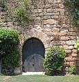
During June 2009, archeological excavations in the courtyard of the building Burj from the Ottoman period exposed a small building that dated to the Byzantine period (5th–7th centuries CE).[2] The surviving parts of the structure include a fortified structure with gun ports (the southwestern end of the center wing) and a sequence of vaults (the northern wing).[2]
Byzantine ceramics have been found here, and a stone with Greek inscription, which had been reused in a Crusader fortress.[3]
Modern History
In 1882, the Palestine Exploration Fund's Survey of Western Palestine (SWP) described it: "Walls and foundations without any indication of date."[4] A population list from about 1887 showed that place, called Burj el Kheil, had about 105 inhabitants; all Muslims.[5]
On October 26, 1898, German Kaiser Wilhelm II stayed at the Burj khan (caravanserei) building during his visit to the Holy Land.[2] Turkish owner, Sidki Pasha, brother of Jamal Pasha, sold 4,000 dunams of the Burj farmland to I.C.A. in 1903.[6] The serious drawback was that most of the land was an uncultivable swamp.[7] Rothschild turned the land over to Binyamina's holdings.[7] Initially a group of farmers from Zichron Ya'akov stayed at the khan, due to distance to their settlement during the week. The group was called Burja’im. Subsequently, Binyamina was founded.[2] A letter from early 1920s describes establishment of Binyamina: "The 'Zichronim' [ people of Zichron Ya'akov ] owners of Burj farm decided to establish a Moshavah in this farm, in order to settle their sons there… "[8]
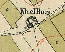
Burj became Binyamina in 1922.[6] In the 1931 census Khirbat Al-Burj was listed under Binyamina.[9] The ownership of the village land was determined in 1934 according to the Land Settlement Ordinances.[10] By the time of the 1945 village survey, there were 5,291 dunums, 15 of which were owned by Arabs, 4,933 owned by Jews, and 343 were public.[11][12] In the 1945 Index Gazetteer, Khirbat Al-Burj was listed as a "village unit" but "no population".[13] According to Khalidi, Khirbat Al-Burj was a Palestinian village which was depopulated by Israelis in 1948.[14] The redsand (hamra) soils from Binyamina to Gedera, west of the coastal plain, were not cultivated till 20th century.[15] Khalidi also says the "village" was "known for its citrus crops" and situated on "rolling terrain".[13] The original economy of Binyamina was citrus-based.[16] According to Frantzman, the 1:20,000 map shows "a large structure, akin to a khan with no indication that it was populated".[13]
Gallery


See also
References
- ↑ Palmer, 1881, p. 145
- 1 2 3 4 Masarwa, 2011, Benyamina, Burj Benyamina
- ↑ Dauphin, 1998, p. 744
- ↑ Conder and Kitchener, 1882, SWP II, p. 52
- ↑ Schumacher, 1888, p. 178
- 1 2 Ramat Hanadiv excavations: final report of the 1984-1998 seasons, by Yizhar Hirschfeld, Adrian J. Boas, p. 664
- 1 2 Avneri, 1984, p. 107
- ↑ Document Regarding the Establishment of Binyamina, early 1920s
- ↑ Mills, 1932, p. 88
- ↑ The Palestine Gazette, Supplement 2 to Issue 475, November 8, 1934, p. 953.
- ↑ Government of Palestine, Department of Statistics. Village Statistics, April, 1945. Quoted in Hadawi, 1970, p. 48
- ↑ Department of Statistics, 1945, p. 14
- 1 2 3 "The Arab settlement of Late Ottoman and Mandatory Palestine: New Village Formation and Settlement Fixation, 1871-1948", Seth J. Frantzman, pp.71-72
- ↑ Khalidi, 1992, p. 156
- ↑ The Jewish people in the first century : historical geography, political history, social, cultural and religious life and institutions. Vol. 2, by Samuel Safrai; M Stern, page 640
- ↑ Jewish National Fund (1949). Jewish Villages in Israel. Jerusalem: Hamadpis Liphshitz Press. p. 24.
- ↑ Survey of Palestine, map Caesarea 1:20,000, 1942. map 14-21.1942
Bibliography
- Avneri, Arieh L. (1984). The Claim of Dispossession: Jewish Land-settlement and the Arabs, 1878-1948. Transaction Publishers. ISBN 0-87855-964-7.
- Conder, Claude Reignier; Kitchener, H. H. (1882). The Survey of Western Palestine: Memoirs of the Topography, Orography, Hydrography, and Archaeology. 2. London: Committee of the Palestine Exploration Fund.
- Dauphin, Claudine (1998). La Palestine byzantine, Peuplement et Populations. BAR International Series 726 (in French). III : Catalogue. Oxford: Archeopress. ISBN 0-860549-05-4.
- Department of Statistics (1945). Village Statistics, April, 1945. Government of Palestine.
- Hadawi, Sami (1970). Village Statistics of 1945: A Classification of Land and Area ownership in Palestine. Palestine Liberation Organization Research Center.
- Khalidi, Walid (1992). All That Remains: The Palestinian Villages Occupied and Depopulated by Israel in 1948. Washington D.C.: Institute for Palestine Studies. ISBN 0-88728-224-5.
- Masarwa, Durar (2011-08-18). "Benyamina, Burj Benyamina" (123). Hadashot Arkheologiyot – Excavations and Surveys in Israel.
- Mills, E., ed. (1932). Census of Palestine 1931. Population of Villages, Towns and Administrative Areas. Jerusalem: Government of Palestine.
- Palmer, E. H. (1881). The Survey of Western Palestine: Arabic and English Name Lists Collected During the Survey by Lieutenants Conder and Kitchener, R. E. Transliterated and Explained by E.H. Palmer. Committee of the Palestine Exploration Fund.
- Schumacher, G. (1888). "Population list of the Liwa of Akka". Quarterly statement - Palestine Exploration Fund. 20: 169–191.
External links
- Welcome To al-Burj, Khirbat
- Khirbat al-Burj (Haifa), Zochrot
- Survey of Western Palestine, Map 8: IAA, Wikimedia commons