Dayr Aban
| Dayr Aban | |
|---|---|
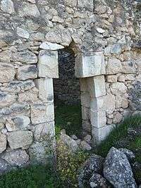 Entrance to a house in Dayr Aban | |
 Dayr Aban | |
| Arabic | دير آبان |
| Name meaning | The Monastery of Aban[1] |
| Subdistrict | Jerusalem |
| Coordinates | 31°44′35″N 35°00′38″E / 31.74306°N 35.01056°ECoordinates: 31°44′35″N 35°00′38″E / 31.74306°N 35.01056°E |
| Palestine grid | 151/127 |
| Population | 2100[2][3] (1945) |
| Area | 22,734 dunams |
| Date of depopulation | October 19–20, 1948[4] |
| Cause(s) of depopulation | Military assault by Yishuv forces |
| Current localities | Tzora,[5] Mahseya,[5] Beit Shemesh,[5] and Yish'i[5] |
Dayr Aban (also spelled Deir Aban; Arabic: دير آبان) was a Palestinian Arab village in the Jerusalem Subdistrict, located on the lower slope of a high ridge that formed the western slope of a mountain, to the east of Beit Shemesh. It was formerly bordered by olive trees to the north, east, and west. The valley, Wadi en-Najil, ran north and south on the west-side of the village. It was depopulated during the 1948 Arab-Israeli War on October 19, 1948, under Operation Ha-Har. It was located 21 km west of Jerusalem.
History
In pre-Roman and Roman times the settlement was referred to as "Abenezer", and may have been the location of the biblical site Eben-Ezer.(1 Samuel 4:1-11).[6][7]
Ottoman era
In 1596, Dayr Aban appeared in Ottoman tax registers as being in the Nahiya of Quds of the Liwa of Quds. It had a population of 23 Muslim households and 23 Christian households;[8] that is, an estimated 127 persons.[9] They paid a fixed tax rate of 33,3% on agricultural products, such as wheat, barley, olives, and goats or beehives; a total of 9,700 Akçe.[8]
Victor Guérin described it in 1863 as being a large village, and its adjacent valley "strewn with sesame."[10] An Ottoman village list from about 1870 found that the village had a population of 443, in a total of 135 houses, though the population count included men, only.[11][12]
In 1883, the Palestine Exploration Fund's Survey of Western Palestine described Dayr Aban as "a large village on the lower slope of a high ridge, with a well to the north, and olives on the east, west, and north. This place no doubt represents the fourth century site of Ebenezer (I Sam. IV. I) which is mentioned in the Onomasticon (s.v. Ebenezer) as near Beth Shemesh. The village is 2 miles east of 'Ain Shems."[7]
In 1896 the population of Der Aban was estimated to be about 921 persons.[13]
British Mandate era
In the 1922 census of Palestine, conducted by the British Mandate authorities, Dair Aban had a population of 1,214 inhabitants, all Muslims,[14] increasing in the 1931 census to 1534 inhabitants, in 321 houses.[15]
In the 1945 statistics, the village had a total population of 2,100 Arabs; 10 Christians and 2090 Muslims,[2] with a total of 22,734 dunums of land.[3] Of this, Arabs used 1,580 dunams for irrigable land or plantations, 14,925 for cereals,[16] while 54 dunams were built-up (urban) Arab land.[17]
Dayr Abban had a mosque and a pipeline transporting water from 'Ayn Marjalayn, 5 km to the east.[5] The village contains three khirbats: Khirbat Jinna'ir, Khirbat Haraza, and Khirbat al-Suyyag.[5]
1948, aftermath
On 4 August 1948, two weeks into the Second truce of the 1948 Arab–Israeli War, Hajj Amin al Husseini noted that ‘for two weeks now . . . the Jews have continued with their attacks on the Arab villages and outposts in all areas. Stormy battles are continuing in the villages of Sataf, Deiraban, Beit Jimal, Ras Abu ‘Amr, ‘Aqqur, and ‘Artuf . . .’[18]
The village became depopulated on 19–20 October 1948, after a military assault during Operation Ha-Har.[4][19][20] Egyptian forces joined by local militias from Dayr Aban had fought alongside each other against the advancing Israeli army.[21] Through the second half of 1948, the IDF, under Ben-Gurion’s tutelage, continued to destroy Arab villages, including Dayr Abban on 22 October 1948.[22]
After the war, the ruin of Dayr Abban remained under Israeli control under the terms of the 1949 Armistice Agreement[23] between Israel and Jordan, until such time that the agreement was dissolved in 1967.[24][25]
The moshav of Mahseya was later established near the site of the old village,[26] on the land of Dayr Aban, as was Tzora, Beit Shemesh and Yish'i.[5]

Etymology
The prefix "Dayr" which appears in many village names is of Aramaic and Syriac-Aramaic origin, and has the connotation of "habitation," or "dwelling place," usually given to places where there was once a Christian population, or settlement of monks. In most cases, a monastery was formerly built there, and, throughout time, the settlement expanded.[27] Dayr Aban would, therefore, literally mean, "the Monastery of Aban."[1]
Gallery
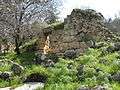 Dayr Aban-Ruin
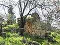 Dayr Aban, stone wall
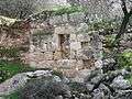 Dayr Aban, stone façade
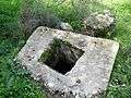 Dayr Aban, Cistern
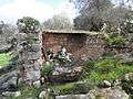 Dayr Aban
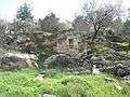 Dayr Aban-Ruin
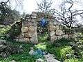 Dayr Aban, in sunlight
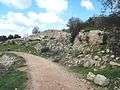 Ruins of Dayr Aban, wall
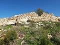 The outer wall of structure in Dayr Aban
 Ruins of Dayr Aban
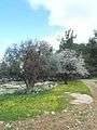 Dayr Aban, Olive and Almond Tree
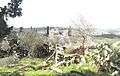 Dayr Aban on the Background of Beit Shemesh
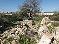 The ruins of Dayr Aban overlooking Beit Shemesh
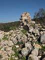 Projecting wall, in Dayr Aban
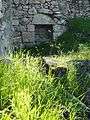 What remains of the inside wall of a house, with niche in wall
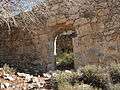 Front wall of house in Dayr Aban
.JPG) Razed buildings in Dayr Aban
Razed buildings in Dayr Aban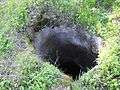 Mouth of pit, one of many in Dayr Aban
 Razed structures in Dayr Aban
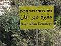 A sign post of the cemetery in Dayr Aban
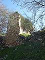 What remains of a house still stands tall
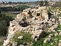 Old structures in Dayr Aban
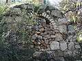 Sealed Archway in Dayr Aban
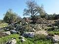 House and tree amidst ruins, in Dayr Aban
References
- 1 2 Palmer, 1881, p. 293
- 1 2 Department of Statistics, 1945, p. 24
- 1 2 Government of Palestine, Department of Statistics. Village Statistics, April, 1945. Quoted in Hadawi, 1970, p. 56
- 1 2 Morris, 2004, p. xx, village #335. Also gives cause of depopulation.
- 1 2 3 4 5 6 7 Khalidi, 1992, p. 283
- ↑ Conder, 1876, p. 149
- 1 2 Conder and Kitchener, 1883, p. 24
- 1 2 Hütteroth and Abdulfattah, 1977, p. 119
- ↑ Khalidi, 1992, p. 282
- ↑ Guérin, 1869, pp. 22-23, 323
- ↑ Socin, 1879, p. 151
- ↑ Hartmann, 1883, p. 145: 150 houses, more than Socin
- ↑ Schick, 1896, p. 123
- ↑ Barron, 1923, Table VII, Sub-district of Ramleh, p. 21
- ↑ Mills, 1932, p. 19
- ↑ Government of Palestine, Department of Statistics. Village Statistics, April, 1945. Quoted in Hadawi, 1970, p. 102
- ↑ Government of Palestine, Department of Statistics. Village Statistics, April, 1945. Quoted in Hadawi, 1970, p. 152
- ↑ Morris, 2004, p. 447, note #211, p. 461
- ↑ Morris, 2004, p. 462
- ↑ Morris, 2004, p. 466, note #13, p. 493
- ↑ Heally Gross, Adamah Ahuvah, Jerusalem 2013, p. 51 (Hebrew)
- ↑ Morris, 2004, p. 355, note #85 Harel Brigade HQ\Intelligence, ‘Daily Report for 22 October’, 23 Oct. 1948, IDFA 4775\49\3, for the destruction of Beit Nattif and Deiraban, p. 400
- ↑ The 1949 Armistice Agreement between Israel and Jordan
- ↑ Enlarged map showing Dayr Abban (Deiraban) in relation to the "Green-Line"
- ↑ Larger map showing "1949 Cease-fire line" (Green-line) between Israel and Jordan (Hebrew)
- ↑ Yalqut Teiman, Yosef Tobi and Shalom Seri (editors), Tel-Aviv 2000, p. 158, s.v. מחסיה (Hebrew) ISBN 965-7121-03-5
- ↑ Al-Shabeshti, Diyārāt (Monasteries).
Bibliography
- Barron, J. B., ed. (1923). Palestine: Report and General Abstracts of the Census of 1922. Government of Palestine.
- Conder, C. R. (1876). "Notes from the Memoir". Quarterly statement - Palestine Exploration Fund. 8: 149– 151.
- Conder, C.R.; Kitchener, H. H. (1883). The Survey of Western Palestine: Memoirs of the Topography, Orography, Hydrography, and Archaeology. 3. London: Committee of the Palestine Exploration Fund.
- Dauphin, Claudine (1998). La Palestine byzantine, Peuplement et Populations. BAR International Series 726 (in French). III : Catalogue. Oxford: Archeopress. ISBN 0-860549-05-4. (p. 909)
- Department of Statistics (1945). Village Statistics, April, 1945. Government of Palestine.
- Guérin, V. (1869). Description Géographique Historique et Archéologique de la Palestine (in French). 1: Judee, pt. 2. Paris: L'Imprimerie Nationale.
- Hadawi, S. (1970). Village Statistics of 1945: A Classification of Land and Area ownership in Palestine. Palestine Liberation Organization Research Centre.
- Hartmann, M. (1883). "Die Ortschaftenliste des Liwa Jerusalem in dem türkischen Staatskalender für Syrien auf das Jahr 1288 der Flucht (1871)". Zeitschrift des Deutschen Palästina-Vereins. 6: 102–149.
- Hütteroth, Wolf-Dieter; Abdulfattah, Kamal (1977). Historical Geography of Palestine, Transjordan and Southern Syria in the Late 16th Century. Erlanger Geographische Arbeiten, Sonderband 5. Erlangen, Germany: Vorstand der Fränkischen Geographischen Gesellschaft. ISBN 3-920405-41-2.
- Khalidi, W. (1992). All That Remains: The Palestinian Villages Occupied and Depopulated by Israel in 1948. Washington D.C.: Institute for Palestine Studies. ISBN 0-88728-224-5.
- Mills, E., ed. (1932). Census of Palestine 1931. Population of Villages, Towns and Administrative Areas. Jerusalem: Government of Palestine.
- Morris, B. (2004). The Birth of the Palestinian Refugee Problem Revisited. Cambridge University Press. ISBN 978-0-521-00967-6.
- Palmer, E. H. (1881). The Survey of Western Palestine: Arabic and English Name Lists Collected During the Survey by Lieutenants Conder and Kitchener, R. E. Transliterated and Explained by E.H. Palmer. Committee of the Palestine Exploration Fund.
- Schick, C. (1896). "Zur Einwohnerzahl des Bezirks Jerusalem". Zeitschrift des Deutschen Palästina-Vereins. 19: 120–127.
- Socin, A. (1879). "Alphabetisches Verzeichniss von Ortschaften des Paschalik Jerusalem". Zeitschrift des Deutschen Palästina-Vereins. 2: 135–163.
External links
- Welcome To Dayr Aban
- Dayr Aban, Zochrot
- Survey of Western Palestine, Map 17: IAA, Wikimedia commons
- Dayr Aban in Antiquity Archaeological Survey of Israel
- Dayr Aban, from the Khalil Sakakini Cultural Center
- Dayr Aban دير آبان Palestine Family.net