Safsaf
| Safsaf | |
|---|---|
 Safsaf | |
| Arabic | صفصاف |
| Name meaning | "the Osier willow"[1] |
| Also spelled | Safsofa |
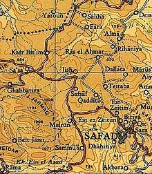
| Subdistrict | Safad |
| Coordinates | 33°00′42″N 35°26′44″E / 33.01167°N 35.44556°ECoordinates: 33°00′42″N 35°26′44″E / 33.01167°N 35.44556°E |
| Palestine grid | 192/268 |
| Population | 910[2][3] (1945) |
| Area | 7,391[3] dunams |
| Date of depopulation | 29 October 1948[4] |
| Cause(s) of depopulation | Military assault by Yishuv forces |
| Secondary cause | Fear of being caught up in the fighting |
| Current localities | Kfar Hoshen,[5][6] Bar Yohai[7] |
Safsaf (Arabic: صفصاف, the weeping willow, also known in Roman times as Safsofa) was a Palestinian village located 9 kilometres northwest of Safed, present-day Israel. Its villagers fled to Lebanon after the Safsaf massacre in October 1948, during the 1948 Arab–Israeli War.
History
The village was called Safsofa in Roman times.[8]
Ottoman era
In the early sixteenth century CE, Safsaf was incorporated into the Ottoman Empire, and by 1596, it was a village in the nahiyah ("subdistrict") of Jira, part of Sanjak Safad. It had a population of 138, and it paid taxes on several agricultural items including wheat, barley, olives and fruits, as well as other types of produce, such as beehives and goats.[9]
In 1875 Victor Guérin described it as a village with fifteen Muslim families.[10]
In 1881 the Palestine Exploration Fund's Survey of Western Palestine described Safsaf as a small village situated on a plain, with a population of about 100. They also noted that "ornamented stones of a preexisting public building" had been built into the doorway of the village mosque.[11] The villagers cultivated olive and fig trees and vineyards.[12]
A population list from about 1887 showed Sufsaf to have about 740 inhabitants, all Muslim.[13]
British Mandate era
Safsaf became a part of the British Mandate in 1922. During this time, the village lay on the eastern side of the Safad-Tarshiha highway and extended in a northeast-southwest direction. All the residents of Safsaf were Muslims. A mosque and several shops were located in the village center, and an elementary school was established during this period. Agriculture was the main economic activity, and it was both irrigated from springs and rainfed. Fruits and olives were cultivated on the land north of the village.[6]
In the 1922 census of Palestine Sufsaf had a population of 521; all Muslim,[14] increasing in the 1931 census to 662, still all Muslims, in a total of 124 houses.[15]
In the 1945 statistics the population was 910 Muslims,[2] with a total of 7,391 dunams of land, according to an official land and population survey.[3] Of this, a total of 2,586 dunums were allotted to cereals; 769 dunums were irrigated or used for orchards,[6][16] while a 72 dunams was built-up (urban) area.[17]
1948, and aftermath
On October 29, 1948, Israeli forces assaulted the village as part of Operation Hiram.[18] After the villagers surrendered, some 50-70 men were massacred while bound and three women were allegedly raped.[6][19][20][21]
See also
References
- ↑ Palmer, 1881, p. 95
- 1 2 Department of Statistics, 1945, p. 11
- 1 2 3 Government of Palestine, Department of Statistics. Village Statistics, April, 1945. Quoted in Hadawi, 1970, p. 71
- ↑ Morris, 2004, p. xvi, village #45. Also gives causes of depopulation.
- ↑ Morris, 2004, p. xxi, Settlement #49, established January 1949.
- 1 2 3 4 Khalidi, 1992, p. 491
- ↑ Established in 1979. Khalidi, 1992, p. 491
- ↑ Khalidi, 1992, p. 490
- ↑ Hütteroth and Abdulfattah, 1977, p.177, quoted in Khalidi, 1992, p. 490.
- ↑ Guérin, 1880, pp. 418- 419
- ↑ Conder and Kitchener, 1881, SWP I, p. 257. Quoted in Khalidi, 1992, p. 491
- ↑ Conder and Kitchener, 1881, SWP I, p.200. Quoted in Khalidi, 1992, p. 491
- ↑ Schumacher, 1888, p. 190
- ↑ Barron, 1923, Table XI, Sub-district of Safad, p. 41
- ↑ Mills, 1932, p. 110
- ↑ Government of Palestine, Department of Statistics. Village Statistics, April, 1945. Quoted in Hadawi, 1970, p. 121
- ↑ Government of Palestine, Department of Statistics. Village Statistics, April, 1945. Quoted in Hadawi, 1970, p. 171
- ↑ Welcome to Safsaf, Palestine Remembered, retrieved 2007-12-12
- ↑ Benvenisti, 2000, p. 153
- ↑ Nazzal, 1978, p. 93-96
- ↑ Morris, 2004, p. 481
Bibliography
- Barron, J. B., ed. (1923). Palestine: Report and General Abstracts of the Census of 1922. Government of Palestine.
- Benveniśtî, M. (2000). Sacred landscape: the buried history of the Holy Land since 1948 (Illustrated ed.). University of California Press. ISBN 0-520-21154-5.
- Conder, C.R.; Kitchener, H.H. (1881). The Survey of Western Palestine: Memoirs of the Topography, Orography, Hydrography, and Archaeology. 1. London: Committee of the Palestine Exploration Fund.
- Department of Statistics (1945). Village Statistics, April, 1945. Government of Palestine.
- Guérin, V. (1880). Description Géographique Historique et Archéologique de la Palestine (in French). 3: Galilee, pt. 2. Paris: L'Imprimerie Nationale.
- Hadawi, S. (1970). Village Statistics of 1945: A Classification of Land and Area ownership in Palestine. Palestine Liberation Organization Research Centre.
- Hütteroth, Wolf-Dieter; Abdulfattah, Kamal (1977). Historical Geography of Palestine, Transjordan and Southern Syria in the Late 16th Century. Erlanger Geographische Arbeiten, Sonderband 5. Erlangen, Germany: Vorstand der Fränkischen Geographischen Gesellschaft. ISBN 3-920405-41-2.
- Khalidi, W. (1992). All That Remains: The Palestinian Villages Occupied and Depopulated by Israel in 1948. Washington D.C.: Institute for Palestine Studies. ISBN 0-88728-224-5.
- Mills, E., ed. (1932). Census of Palestine 1931. Population of Villages, Towns and Administrative Areas. Jerusalem: Government of Palestine.
- Morris, B. (2004). The Birth of the Palestinian Refugee Problem Revisited. Cambridge University Press. ISBN 978-0-521-00967-6.
- Nazzal, Nafez (1978). The Palestinian Exodus from Galilee 1948. Beirut: The Institute for Palestine Studies. (Safsaf, p. 93-96, 107)
- Palmer, E.H. (1881). The Survey of Western Palestine: Arabic and English Name Lists Collected During the Survey by Lieutenants Conder and Kitchener, R. E. Transliterated and Explained by E.H. Palmer. Committee of the Palestine Exploration Fund.
- Schumacher, G. (1888). "Population list of the Liwa of Akka". Quarterly statement - Palestine Exploration Fund. 20: 169–191.
- Strange, le, G. (1890). Palestine Under the Moslems: A Description of Syria and the Holy Land from A.D. 650 to 1500. Committee of the Palestine Exploration Fund.
External links
- welcome to safsaf - Nidal Hamad
- Welcome to Safsaf
- Safsaf, Zochrot
- Survey of Western Palestine, Map 4: IAA, Wikimedia commons
- Safsaf, from the Khalil Sakakini Cultural Center
- Safsaf photos, Dr. Moslih Kanaaneh
- Safsaf, Dr. Khalil Rizk.