Person County, North Carolina
Person County is a county located in the U.S. state of North Carolina. The population was 39,464 at the 2010 census.[1] The county seat is Roxboro.[2]
Person County | |
|---|---|
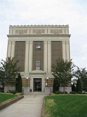 Person County Courthouse | |
 Seal | |
 Location within the U.S. state of North Carolina | |
 North Carolina's location within the U.S. | |
| Coordinates: 36°23′N 78°59′W | |
| Country | |
| State | |
| Founded | 1791 |
| Named for | Thomas Person |
| Seat | Roxboro |
| Largest city | Roxboro |
| Area | |
| • Total | 404 sq mi (1,050 km2) |
| • Land | 392 sq mi (1,020 km2) |
| • Water | 12 sq mi (30 km2) 2.9%% |
| Population | |
| • Estimate (2018) | 39,507 |
| • Density | 101/sq mi (39/km2) |
| Time zone | UTC−5 (Eastern) |
| • Summer (DST) | UTC−4 (EDT) |
| Congressional district | 6th |
| Website | www |
Person County is included in the Durham-Chapel Hill Metropolitan Statistical Area, which is also included in the Raleigh-Durham-Chapel Hill Combined Statistical Area, which had an estimated population of 1,998,808 in 2012.[3] It is located in the Piedmont region of North Carolina.
The Hyco Lake area and southern portion of the county are the fastest growing with new commercial development and subdivisions.
History
The colonial government established Person County as part of Edgecombe County in 1746. County designations kept changing, and it was part of Granville County from 1746–1752; included in Orange County until 1778; and part of Caswell County until 1791/1792. By dividing Caswell County into two squares–each side measuring approximately twenty (20) miles in length, the settlers formed two counties of 400 square miles (1,000 km2) each. The county was named after Brigadier General Thomas Person, a Revolutionary War patriot, who made significant contributions to Person County and surrounding areas.
The area had been inhabited by Native Americans for as long as possibly 12,000 years. The historical tribes encountered here by early Spanish explorers were generally Siouan-speaking, including the Saponi, Occaneechee, and other groups.
Settlement by immigrants of Scots, Scots-Irish, English, French Huguenot, and German ancestry began in the mid-17th and continued into the 19th centuries. The settlers tended to be yeoman farmers, and few owned any slaves.
Religious affiliation in the county reflects the early settlers and is predominantly Protestant. Due to Person County's nearness to Virginia, the Carolina coast, and the Appalachian foothills, a wide variety of Southern American English dialects can be heard here, including Virginia Piedmont, Coastal Southern, South Midland, and African-American English.
Revolutionary and Civil Wars
The county was named for Brigadier General Thomas Person, a Revolutionary War patriot, who made significant contributions to Person County and surrounding areas. He was a trustee of the University of North Carolina at Chapel Hill. His generous donations were recognized by the construction and naming of Person Hall.
Lieutenant Colonel Stephen Moore, Deputy Quartermaster General of the Hillsborough district, was another Revolutionary War hero, commanding the Person County militia at the disastrous Battle of Camden. He was captured and held on the prison ship Torbay. In 1775-1776 he had purchased property in the south of Person County and named his plantation Mt. Tirzah. His home, constructed in 1778, has been renovated recently. Stephen Moore was buried in the family cemetery.
During the Civil War, Person County supplied between 800 and 1000 soldiers to the Confederate Army. A granite monument at the Courthouse honors E. Fletcher Satterfield, who carried the Confederate flag at Gettysburg.
Late 19th century
J.A. Long, W.W. Kitchin, A.R. Foushee, J.S. Bradsher, J.C. Pass, W.F. Reade, and R.E. Long were key leaders who helped make a transition to a more diversified economic base after the Civil War. The arrival of the newly constructed Norfolk and Western Railroad was a major influence around 1890, as it enabled the addition of tobacco processing plants and warehouses to the rural economy. Although the processing plants disappeared many years ago, a few of the warehouses still stand.
J.A. Long established Peoples Bank in 1891 and the Roxboro Cotton Mill in 1899, later known as Tultex Yarns. His home at Roxboro, the James A. and Laura Thompson Long House, was added to the National Register of Historic Places in 2005.[4] Long died in 1915 but was succeeded by his son, J.A. Long, Jr., who began attracting new business to Roxboro. Baker Company opened here in 1923, making textile manufacturing a major contributor to the local economy for decades. Baker was merged with Collins and Aikman Corporation (C&A), becoming a major industry in Person County for several decades before closing in August 2006. Textile manufacturers have moved to other locations in the US and overseas.
20th and 21st centuries
Residential and commercial development have grown steadily over the past few years in part due to the county's location near the Research Triangle region. The Hyco Lake area and southern portion of the county have had an influx of new home and commercial development in the late 20th and early 21st-century. The county's largest employers are Duke Energy, Eaton Corporation, Georgia-Pacific Corporation and GKN Driveline.
The Holloway-Walker Dollarhite House, Henry-Vernon House, Burleigh, and Waverly Plantation are listed on the National Register of Historic Places outside Roxboro.[4]
Geography
According to the U.S. Census Bureau, the county has a total area of 404 square miles (1,050 km2), of which 392 square miles (1,020 km2) is land and 12 square miles (31 km2) (2.9%) is water.[5]
Person County contains parts of three major river basins: the Neuse, the Roanoke and the Tar, providing essential clean drinking water to the south and east of the state. The origin of the Tar River is in southeast Person County. In the northwest section of the county is Hyco Lake, with Mayo Reservoir in the northeast section. Both lakes are used for electrical power generation and recreation. Near the western border with Caswell County is Lake Roxboro. Part of the Neuse River begins here with the Flat River, where it combines with the Little and Eno rivers to go into Falls Lake and create the Neuse.
The Uwharrie Mountains, part of North Carolina's easternmost mountain range, are the oldest mountain range in North America. They are the lowest mountain range in the state. The Uwharries begin in Montgomery County and terminate at Hager's Mountain in the hills of northern Person County.
The county is largely covered by rolling hills divided by farmlands and forest. The area's ridges are not narrow and sharp like those in some parts of the Piedmont, and the gullies and ditches are not as abrupt. The northern part of the county between the lakes is skirted by a plateau. The highest point of the county is a prominent hill in Roxboro, where the county seat has located its water reservoir tank. Person County claims three small mountains. Hager's Mountain is north of Roxboro. Red Mountain and Mt. Tirzah are in the southeastern part of the county. The geology of the county is dominated by igneous formation, overlaid by a variety of soils. Granite boulders are strewn across the county.
Demographics
| Historical population | |||
|---|---|---|---|
| Census | Pop. | %± | |
| 1800 | 6,402 | — | |
| 1810 | 6,642 | 3.7% | |
| 1820 | 9,029 | 35.9% | |
| 1830 | 10,027 | 11.1% | |
| 1840 | 9,790 | −2.4% | |
| 1850 | 10,781 | 10.1% | |
| 1860 | 11,221 | 4.1% | |
| 1870 | 11,170 | −0.5% | |
| 1880 | 13,719 | 22.8% | |
| 1890 | 15,151 | 10.4% | |
| 1900 | 16,685 | 10.1% | |
| 1910 | 17,356 | 4.0% | |
| 1920 | 18,973 | 9.3% | |
| 1930 | 22,039 | 16.2% | |
| 1940 | 25,029 | 13.6% | |
| 1950 | 24,361 | −2.7% | |
| 1960 | 26,394 | 8.3% | |
| 1970 | 25,914 | −1.8% | |
| 1980 | 29,164 | 12.5% | |
| 1990 | 30,180 | 3.5% | |
| 2000 | 35,623 | 18.0% | |
| 2010 | 39,464 | 10.8% | |
| Est. 2018 | 39,507 | [6] | 0.1% |
| U.S. Decennial Census[7] 1790-1960[8] 1900-1990[9] 1990-2000[10] 2010-2013[1] | |||
As of the census[11] of 2010, there were 39,464 people, 15,826 households, and 10,979 families residing in the county. The population density was 91 people per square mile (35/km²). There were 15,504 housing units at an average density of 40 per square mile (15/km²). The racial makeup of the county was 68.1% White, 28.3% Black, 0.61% Native American, 0.15% Asian, 0.01% Pacific Islander, 1.37% from other races, and 0.86% from two or more races. Hispanic or Latino people of any race were 2.09% of the population.
There were 14,085 households out of which 31.5% had children under the age of 18 living with them, 53.8% were married couples living together, 13.8% had a female householder with no husband present, and 28.2% were non-families. 24.2% of all households were made up of individuals and 10.1% had someone living alone who was 65 years of age or older. The average household size was 2.50 and the average family size was 2.95.
In the county, the population was spread out with 24.0% under the age of 18, 7.4% from 18 to 24, 30.6% from 25 to 44, 24.2% from 45 to 64, and 13.3% who were 65 years of age or older. The median age was 38 years. For every 100 females there were 93.2 males. For every 100 females age 18 and over, there were 90.2 males.
The median income for a household in the county was $42,559 and the median income for a family was $54,474. Males had a median income of $30,970 versus $22,804 for females. The per capita income for the county was $22,189. About 9.4% of families and 12.0% of the population were below the poverty line, including 14.9% of those under age 18 and 17.3% of those age 65 or over.
Communities
City
- Roxboro (county seat)
Census-designated place
Townships
- Allensville
- Bushy Fork
- Cunningham
- Flat River
- Holloway
- Mount Tirzah
- Olive Hill
- Roxboro
- Woodsdale
Unincorporated communities
- Ai
- Allensville
- Bethel Hill
- Brooksdale
- Bushy Fork
- Cavel
- Ceffo
- Concord
- Cunningham
- Denny Store
- Five Forks
- Gentry Store
- Gordonton
- Hesters Store
- Hurdle Mills
- Leasburg
- Longhurst
- Longs Store
- Moriah
- Mount Tirzah
- Olive Hill
- Paynes Tavern
- Peeds Store
- Roseville
- Semora
- Somerset
- Surl
- Timberlake
- Triple Springs
- Whitt Town
- Woodsdale
Politics, law and government
Person County is a member of the Kerr-Tar Regional Council of Governments. The county government is administered by an elected county commission, and county law enforcement is administered by an elected sheriff and his officers. The county is politically conservative and Republican. No Democratic presidential candidate has carried Person County since Jimmy Carter did so in 1980; however before being won by George Wallace in 1968, Person County had been part of the "Solid South" and voted Democratic at every election between 1912 and 1964, with six consecutive Democratic presidential nominees receiving seventy-five percent of the county's vote between 1932 and 1952.
| Year | Republican | Democratic | Third parties |
|---|---|---|---|
| 2016 | 57.0% 11,185 | 39.9% 7,833 | 3.0% 597 |
| 2012 | 54.9% 10,496 | 44.1% 8,418 | 1.0% 192 |
| 2008 | 53.8% 10,030 | 45.3% 8,446 | 0.8% 156 |
| 2004 | 59.0% 8,973 | 40.7% 6,198 | 0.3% 43 |
| 2000 | 56.8% 6,722 | 42.6% 5,042 | 0.6% 69 |
| 1996 | 48.7% 4,883 | 45.3% 4,540 | 6.1% 607 |
| 1992 | 43.6% 4,460 | 42.3% 4,323 | 14.2% 1,447 |
| 1988 | 56.0% 4,832 | 43.8% 3,777 | 0.2% 19 |
| 1984 | 62.3% 5,854 | 37.5% 3,528 | 0.2% 15 |
| 1980 | 43.6% 3,281 | 54.6% 4,111 | 1.9% 142 |
| 1976 | 43.2% 3,038 | 56.6% 3,977 | 0.3% 18 |
| 1972 | 71.9% 5,941 | 27.2% 2,246 | 0.9% 77 |
| 1968 | 24.2% 2,138 | 29.9% 2,644 | 46.0% 4,065 |
| 1964 | 31.3% 2,162 | 68.7% 4,740 | |
| 1960 | 30.9% 1,926 | 69.1% 4,305 | |
| 1956 | 33.6% 1,740 | 66.4% 3,433 | |
| 1952 | 24.4% 1,374 | 75.6% 4,266 | |
| 1948 | 12.8% 480 | 82.3% 3,087 | 4.9% 185 |
| 1944 | 19.5% 607 | 80.5% 2,507 | |
| 1940 | 11.8% 432 | 88.2% 3,239 | |
| 1936 | 11.7% 384 | 88.3% 2,898 | |
| 1932 | 21.7% 660 | 77.8% 2,372 | 0.6% 17 |
| 1928 | 47.6% 1,123 | 52.4% 1,235 | |
| 1924 | 39.4% 1,025 | 60.5% 1,576 | 0.1% 3 |
| 1920 | 48.8% 1,566 | 51.3% 1,646 | |
| 1916 | 49.0% 917 | 51.0% 953 | |
| 1912 | 43.9% 784 | 45.9% 820 | 10.3% 184 |
Elected officials
- Mark Walker (R), U.S. House of Representative
- Mike Woodard (D), State Senator
- Larry Yarborough (R), State Representative
- Dewey Jones (D), Sheriff
- Kyle Puryear (R), County Commissioner
- David Newell (R), Chairman- County Commissioner
- Ray Jeffers (D), County Commissioner
- Jimmy Clayton (D), County Commissioner
- Gordon Powell, Vice Chair, County Commissioner
- Jimmy Wilkins, School Board Vice-Chairman
- Jennifer Kafer, School Board Member
- Freda Tillman, School Board Member
- Margaret Bradsher, School Board Member
Economy
The economy of Person County is dominated by electrical, textile, administrative, manufacturing, aerodynamics, viticulture, brokering, food processing, automotive, aluminum and paper products. Diversification from traditional flue cured tobacco to include burley tobacco and other modes of agriculture is underway.
Person County is home to two industrial parks: Person County Business and Industrial Center (PCBIC), located on Durham Road (US 501), and North Park, located north of Roxboro on North Park Drive.
Person County is also near North Carolina's Research Triangle, home to numerous high-tech companies and enterprises.
Person County offers a strategic location for business and industry, as it is within an hour's drive of North Carolina's two major economic centers, the Research Triangle (Durham, Chapel Hill and Raleigh) and the Piedmont Triad (Greensboro, Winston-Salem and High Point), and within a two-hour drive of Richmond, Virginia.
Healthcare
- Person Memorial Hospital
- Hospital of the Duke University Health System
- Roxboro MedAccess
Person County Medical and Dental
Education
Higher education
- Piedmont Community College offers associate degrees, technical training programs, and college credit which is transferable to local state supported colleges/universities. There is a satellite campus in neighboring Caswell County.
Public education
Person County School System
Public education is provided by the Person County School System and administers a single unified school district with a K-12 program. As of August 2013, the school system consists of:
- 4,500+ students
- 690+ staff
| Name | Principal/director | Mascot | Colors | Enrollment as of fall 2013 |
|---|---|---|---|---|
| Earl Bradsher Pre-School Center (Pre-K) | Treco Lea-Jeffers, Director | Shining Stars | 186 | |
| Early Intervention & Family Services (Pre-K) | Dana Faulkner, Director | |||
| Helena Elementary (K-5) | Chrystal Clayton, Principal | Hornets | Black, yellow | 647 |
| North Elementary (K-5) | Patti Barnes, Principal | Eagles | Red, gold, orange | 292 |
| North End Elementary (K-5) | Sherita Fuller, Principal | Jets | Red, blue | 209 |
| Oak Lane Elementary (K-5) | Amy Seate, Principal | Cougars | Green, white | 280 |
| Stories Creek Elementary (K-5) | Dusty Martin, Principal | Gators | Green, yellow | 453 |
| South Elementary (K-5) | Patrick Holmes, Principal | Shooting Stars | Orange, yellow | 233 |
| Woodland Elementary (K-5) | Joseph Warren, Principal | Lakers | Blue, white | 223 |
| Northern Middle (6-8) | Ashley Warren, Principal | Raiders | Purple, blue, black | 476 |
| Southern Middle (6-8) | Melody Wilson, Principal | Panthers | Blue, white | 601 |
| Person High (9-12) | Dr. Jonte' Hill, Principal | Rockets | Blue, white, cardinal | 1,325 |
| Person County Learning Academy (alternative school; 6-10) | Joan Kister, Director | 50 |
Charter schools
The State of North Carolina also provides for a certain number of charter schools. These are administered separately from the Person County School System. Roxboro has two charter schools:
- Bethel Hill Charter School, an alternative public school that offers young kids an alternative for grades K-6, opened for the 2000-2001 school year. Total enrollment is 385.
- Roxboro Community School, an alternative to the state public school system, is located in uptown Roxboro. It is housed in the historic Roxboro Cotton Mill/Tultex building, which is on the National Register of Historic Places. The school opened for the 2006-2007 school year. Currently serves grades 6-12. Total enrollment is 700.
Private education
- Person Christian School
- Roxboro Christian Academy was founded in 1976 and serves a K-12 program. Total enrollment is 176.
- Zion Christian Academy was founded in 2002 and offers a 1-12 program. Total enrollment is 30.
Transportation
Air
- Person County Airport, located 6 miles (10 km) south of Roxboro on U.S. Route 501
- Raleigh-Durham International Airport, located 42 miles (68 km) south of Roxboro
- Piedmont Triad International Airport, located 82 miles (132 km) southwest of Roxboro
Major highways
Interstate 85 is the closest interstate highway to the county, located 29 miles south in Durham.
Railroad
- Norfolk Southern - freight rail service
Notable people
- Henry Atkinson, soldier
- Leonidas Berry, medical doctor, inventor of Eder-Berry biopsy gastroscope[13]
- Robert L. Blackwell, one of two soldiers from North Carolina to receive the Medal of Honor for service during World War I; killed in action October 11, 1918
- Margie Bowes, country music singer
- Michael Brooks, defensive tackle for the Seattle Seahawks
- Carl Long, NASCAR driver
- Wendy Palmer, former WNBA player
- Ray Scott, country music singer
- Enos Slaughter, aka "Country", St. Louis Cardinals, and Baseball Hall of Fame inductee
- Jim Thorpe, Champions Tour golfer
- Luke Torian, politician, Virginia House of Delegates 52nd District
References
- "State & County QuickFacts". United States Census Bureau. Archived from the original on June 7, 2011. Retrieved October 29, 2013.
- "Find a County". National Association of Counties. Retrieved 2011-06-07.
- "Population Estimates 2012 Combined Statistical Areas: April 1, 2010 to July 1, 2012". U.S. Census Bureau. Archived from the original on March 17, 2013. Retrieved 2013-03-14.
- "National Register Information System". National Register of Historic Places. National Park Service. July 9, 2010.
- "2010 Census Gazetteer Files". United States Census Bureau. August 22, 2012. Archived from the original on January 12, 2015. Retrieved January 18, 2015.
- "Population and Housing Unit Estimates". Retrieved July 24, 2019.
- "U.S. Decennial Census". United States Census Bureau. Retrieved January 18, 2015.
- "Historical Census Browser". University of Virginia Library. Retrieved January 18, 2015.
- Forstall, Richard L., ed. (March 27, 1995). "Population of Counties by Decennial Census: 1900 to 1990". United States Census Bureau. Retrieved January 18, 2015.
- "Census 2000 PHC-T-4. Ranking Tables for Counties: 1990 and 2000" (PDF). United States Census Bureau. April 2, 2001. Retrieved January 18, 2015.
- "U.S. Census website". United States Census Bureau. Retrieved 2008-01-31.
- Leip, David. "Dave Leip's Atlas of U.S. Presidential Elections". uselectionatlas.org. Retrieved 2018-03-17.
- Society, National Geographic (2011-01-21). "African-American Inventors III". National Geographic Society. Retrieved 2018-03-17.
External links
- Person County government
- Roxboro Area Chamber of Commerce
- NCGenWeb Person County - free genealogy resources for the county
- Person County Economic Development
- The Courier-Times
- Person Memorial Hospital
- Business Development & Entrepreneurship Center
Places adjacent to Person County, North Carolina | ||||||||||
|---|---|---|---|---|---|---|---|---|---|---|
| ||||||||||
Municipalities and communities of Person County, North Carolina, United States | ||
|---|---|---|
| City | 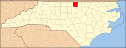 | |
| CDP | ||
| Unincorporated communities | ||
| Footnotes | ‡This populated place also has portions in an adjacent county or counties | |
Greater Durham-Chapel Hill Metropolitan Region (Durham MSA, part of the Research Triangle) | ||
|---|---|---|
| Principal cities | 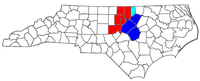 | |
| Other significant cities | ||
| Counties | ||
| Major universities | ||
| Transportation |
| |
| Newspapers | ||
| Miscellaneous | ||


| Authority control |
|
|---|