Dare County, North Carolina
Dare County is the easternmost county in the U.S. state of North Carolina. As of the 2010 Census, the population was 33,920.[1] Its county seat is Manteo.[2] The county is named after Virginia Dare, the first child born in the Americas to English parents, who was born in what is now Dare County.[3]
Dare County | |
|---|---|
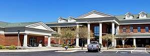 Dare County Administration Building in Manteo | |
 Seal | |
 Location within the U.S. state of North Carolina | |
 North Carolina's location within the U.S. | |
| Coordinates: 35°41′N 75°44′W | |
| Country | |
| State | |
| Founded | 1870 |
| Named for | Virginia Dare |
| Seat | Manteo |
| Largest town | Kill Devil Hills |
| Area | |
| • Total | 1,563 sq mi (4,050 km2) |
| • Land | 383 sq mi (990 km2) |
| • Water | 1,179 sq mi (3,050 km2) 75%% |
| Population | |
| • Estimate (2018) | 36,501 |
| • Density | 88/sq mi (34/km2) |
| Time zone | UTC−5 (Eastern) |
| • Summer (DST) | UTC−4 (EDT) |
| Congressional district | 3rd |
| Website | www |
Dare County is included in the Kill Devil Hills, NC Micropolitan Statistical Area, which is also included in the Virginia Beach-Norfolk, VA-NC Combined Statistical Area.
At one time, the now-abandoned town of Buffalo City was the largest community in the county.[4] Because it includes much of Pamlico Sound, Dare County is the largest county in North Carolina by total area, although if one were to consider land area only, it drops down to 68th in size among the state's 100 counties. This is because, according to the Census Bureau's 2010 statistics, only 24.54% of its area is land, the lowest percentage of all counties in the state. Robeson County is the largest county in North Carolina by land area only.
Geography
According to the U.S. Census Bureau, the county has a total area of 1,563 square miles (4,050 km2), of which 383 square miles (990 km2) is land and 1,179 square miles (3,050 km2) (75%) is water.[5] It is the largest county in North Carolina by area.
Dare County includes the middle part of the Outer Banks and contains Roanoke Island.
Demographics
| Historical population | |||
|---|---|---|---|
| Census | Pop. | %± | |
| 1870 | 2,778 | — | |
| 1880 | 3,243 | 16.7% | |
| 1890 | 3,768 | 16.2% | |
| 1900 | 4,757 | 26.2% | |
| 1910 | 4,841 | 1.8% | |
| 1920 | 5,115 | 5.7% | |
| 1930 | 5,202 | 1.7% | |
| 1940 | 6,401 | 23.0% | |
| 1950 | 5,405 | −15.6% | |
| 1960 | 5,935 | 9.8% | |
| 1970 | 6,995 | 17.9% | |
| 1980 | 13,377 | 91.2% | |
| 1990 | 22,746 | 70.0% | |
| 2000 | 29,959 | 31.7% | |
| 2010 | 33,920 | 13.2% | |
| Est. 2018 | 36,501 | [6] | 7.6% |
| U.S. Decennial Census[7] 1790-1960[8] 1900-1990[9] 1990-2000[10] 2010-2013[1] | |||
As of the census[11] of 2010, there were 33,920 people, 12,690 households, and 8,450 families residing in the county. The population density was 78 people per square mile (30/km2). There were 26,671 housing units at an average density of 70 per square mile (27/km2). The racial makeup of the county was 92.3% White, 2.5% Black or African American, 0.4% Native American, 0.6% Asian, 0.0% Pacific Islander, 2.4% from other races, and 1.8% from two or more races. 6.5% of the population were Hispanic or Latino of any race.
There were 12,690 households out of which 27.30% had children under the age of 18 living with them, 55.00% were married couples living together, 8.10% had a female householder with no husband present, and 33.40% were non-families. 25.00% of all households were made up of individuals and 7.90% had someone living alone who was 65 years of age or older. The average household size was 2.34 and the average family size was 2.79.
In the county, the population was spread out with 21.40% under the age of 18, 6.30% from 18 to 24, 30.80% from 25 to 44, 27.70% from 45 to 64, and 13.80% who were 65 years of age or older. The median age was 40 years. For every 100 females there were 101.50 males. For every 100 females age 18 and over, there were 100.20 males.
The median income for a household in the county was $42,411, and the median income for a family was $49,302. Males had a median income of $31,240 versus $24,318 for females. The per capita income for the county was $23,614. About 5.50% of families and 8.00% of the population were below the poverty line, including 9.90% of those under age 18 and 5.30% of those age 65 or over.
Ancestry
As of 2010, the largest self-reported ancestry groups in Dare County were:[12]
| Largest ancestries (2010) | Percent |
|---|---|
| English | 22.0% |
| German | 18.4% |
| Irish | 15.3% |
| "American" | 8.7% |
| Italian | 6.2% |
| Scottish | 4.8% |
| Scots-Irish | 4.0% |
| Polish | 3.0% |
| Dutch | 1.8% |
| Welsh | 1.2% |
Communities

Towns
- Duck
- Kill Devil Hills
- Kitty Hawk
- Manteo (county seat)
- Nags Head
- Southern Shores
Townships
- Atlantic Township
- Croatan Township
- East Lake Township
- Hatteras Township
- Kinnekeet Township
- Nags Head Township
Unincorporated communities
- Buffalo City
- Colington
- East Lake
- Little Kinnekeet
- Martins Point
- Sanderling
- Scarborotown
- Stumpy Point
Politics
Dare at present is a strongly Republican county. No Democratic presidential nominee has carried Dare County since Jimmy Carter did so in 1976. Before the 1970s it was a typical “Solid South” Democratic county that did not vote Republican between 1900 and 1952.
| Year | Republican | Democratic | Third parties |
|---|---|---|---|
| 2016 | 58.4% 11,460 | 36.8% 7,222 | 4.7% 927 |
| 2012 | 57.0% 10,248 | 41.1% 7,393 | 1.9% 333 |
| 2008 | 54.0% 9,745 | 44.7% 8,074 | 1.3% 229 |
| 2004 | 60.1% 9,345 | 39.5% 6,136 | 0.4% 67 |
| 2000 | 56.2% 7,301 | 43.0% 5,589 | 0.9% 112 |
| 1996 | 46.0% 4,977 | 41.8% 4,522 | 12.2% 1,321 |
| 1992 | 40.7% 4,357 | 36.7% 3,925 | 22.6% 2,414 |
| 1988 | 64.9% 5,234 | 34.8% 2,806 | 0.4% 31 |
| 1984 | 71.8% 4,738 | 27.9% 1,839 | 0.3% 19 |
| 1980 | 49.8% 2,794 | 44.5% 2,497 | 5.8% 324 |
| 1976 | 43.2% 1,680 | 56.3% 2,191 | 0.5% 20 |
| 1972 | 75.2% 1,986 | 24.0% 634 | 0.8% 21 |
| 1968 | 40.1% 1,035 | 27.1% 700 | 32.7% 844 |
| 1964 | 37.0% 867 | 63.0% 1,476 | |
| 1960 | 45.9% 1,058 | 54.1% 1,247 | |
| 1956 | 55.1% 1,028 | 44.9% 839 | |
| 1952 | 44.4% 767 | 55.6% 959 | |
| 1948 | 30.7% 373 | 66.1% 802 | 3.2% 39 |
| 1944 | 21.1% 259 | 78.9% 966 | |
| 1940 | 20.6% 315 | 79.4% 1,214 | |
| 1936 | 28.1% 542 | 71.9% 1,389 | |
| 1932 | 28.5% 497 | 71.2% 1,241 | 0.3% 6 |
| 1928 | 48.0% 814 | 52.0% 883 | |
| 1924 | 43.2% 629 | 56.7% 826 | 0.1% 2 |
| 1920 | 43.4% 632 | 56.6% 825 | |
| 1916 | 43.6% 363 | 56.4% 470 | |
| 1912 | 33.3% 238 | 55.5% 397 | 11.2% 80 |
2016 presidential election
In the 2016 Republican primary, Donald Trump received 2,650 votes in Dare County followed by Ted Cruz who came in second with 1,156 votes. In the 2016 Democratic Primary, Bernie Sanders received 2,307 votes whereas Hillary Clinton only won 2,003 votes.[14] In the general election Donald Trump received 11,460 votes (or 58.4% of the total vote) whereas Hillary Clinton received 7,222 votes (36.8% of the vote) and Libertarian Candidate Gary Johnson received 674 votes (3.4% of total votes in the county).[15] In this regards Dare County has the distinction of being one of many counties in the state of North Carolina which Donald Trump won in both the primary election and the general election, and which Hillary Clinton lost in both the primary election and the general election.
Law and government
Dare County is governed by the Dare County Board of Commissioners. Dare County is a part of the Albemarle Commission regional council of governments.
Lighthouses
Dare County is home to two popular lighthouses: The Cape Hatteras Lighthouse and the Bodie Island Lighthouse. There is also a beacon atop the Wright Brothers Memorial. A third lighthouse was built by the Town of Manteo and dedicated on September 25, 2004. The Roanoke Marshes Lighthouse is an exterior recreation of the 1877 screwpile lighthouse of the same name and is located on the Manteo waterfront. It serves as exhibit space for the N.C. Maritime Museum on Roanoke Island.
Transportation
Airport
Dare County Regional Airport, a general aviation airport, is located in Dare County.
Education
Public education is run by Dare County Schools:
- Manteo High School
- Manteo Middle School
- Manteo Elementary School
- First Flight High School
- First Flight Middle School
- First Flight Elementary School
- Kitty Hawk Elementary School
- Dare County Alternative School
- Cape Hatteras Secondary School
- Cape Hatteras Elementary School
- Nags Head Elementary School
References
- "State & County QuickFacts". United States Census Bureau. Archived from the original on June 6, 2011. Retrieved October 19, 2013.
- "Find a County". National Association of Counties. Archived from the original on 2011-05-31. Retrieved 2011-06-07.
- "About Dare County". Dare County. Archived from the original on 3 April 2012. Retrieved 7 January 2015.
- Degregory, Lane (1994-10-02). "Buffalo City". The Virginian-Pilot. Archived from the original on 2008-05-17. Retrieved 2008-05-06.
- "2010 Census Gazetteer Files". United States Census Bureau. August 22, 2012. Archived from the original on January 12, 2015. Retrieved January 14, 2015.
- "Population and Housing Unit Estimates". Retrieved June 9, 2017.
- "U.S. Decennial Census". United States Census Bureau. Retrieved January 14, 2015.
- "Historical Census Browser". University of Virginia Library. Retrieved January 14, 2015.
- Forstall, Richard L., ed. (March 27, 1995). "Population of Counties by Decennial Census: 1900 to 1990". United States Census Bureau. Retrieved January 14, 2015.
- "Census 2000 PHC-T-4. Ranking Tables for Counties: 1990 and 2000" (PDF). United States Census Bureau. April 2, 2001. Retrieved January 14, 2015.
- "U.S. Census website". United States Census Bureau. Retrieved 2008-01-31.
- Bureau, U.S. Census. "American FactFinder - Results". factfinder.census.gov. Archived from the original on 2020-02-13. Retrieved 2018-03-15.
- Leip, David. "Dave Leip's Atlas of U.S. Presidential Elections". uselectionatlas.org. Retrieved 2018-03-15.
- "North Carolina Primary Election Results 2016". The New York Times. 2016-09-29. ISSN 0362-4331. Retrieved 2018-03-15.
- "North Carolina Election Results 2016". The New York Times. 2017-08-01. ISSN 0362-4331. Retrieved 2018-03-15.
Places adjacent to Dare County, North Carolina | ||||||||||
|---|---|---|---|---|---|---|---|---|---|---|
| ||||||||||
Municipalities and communities of Dare County, North Carolina, United States | ||
|---|---|---|
| Towns | 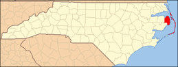 Dare County map | |
| CDPs | ||
| Unincorporated communities | ||
| Ghost town | ||


| Authority control |
|
|---|