Macon County, North Carolina
Macon County is a county located in the U.S. state of North Carolina. As of the 2010 census, the population was 33,922.[1] Its county seat is Franklin.[2]
Macon County | |
|---|---|
.jpg) The Macon County Courthouse in Franklin | |
 Seal | |
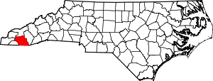 Location within the U.S. state of North Carolina | |
 North Carolina's location within the U.S. | |
| Coordinates: 35.15°N 83.42°W | |
| Country | |
| State | |
| Founded | 1828 |
| Named for | Nathaniel Macon |
| Seat | Franklin |
| Largest town | Franklin |
| Area | |
| • Total | 520 sq mi (1,300 km2) |
| • Land | 516 sq mi (1,340 km2) |
| • Water | 4.1 sq mi (11 km2) 0.8%% |
| Population | |
| • Estimate (2018) | 35,285 |
| • Density | 66/sq mi (25/km2) |
| Time zone | UTC−5 (Eastern) |
| • Summer (DST) | UTC−4 (EDT) |
| Congressional district | 11th |
| Website | www |
Macon County is the home of the Nantahala River (along with Swain County, North Carolina). The Nantahala is one of the most popular whitewater rafting destinations in the nation.[3][4]
History
The county was formed in 1828 from the western part of Haywood County. It was named for Nathaniel Macon,[5] who represented North Carolina in the United States House of Representatives from 1791 to 1815 (serving as Speaker of the House from 1801 to 1807), and in the United States Senate from 1815 to 1828.
In 1839 the western part of Macon County became Cherokee County. In 1851 parts of Macon County and Haywood County were combined to form Jackson County.
.jpg)
.jpg)
Geography
According to the U.S. Census Bureau, the county has a total area of 520 square miles (1,300 km2), of which 516 square miles (1,340 km2) is land and 4.1 square miles (11 km2) (0.8%) is water.[6]
Of the land in Macon County, 239.31 square miles (620 km2) (46.1%) are federal lands that lie within the Nantahala National Forest and are administered by the United States Forest Service. Of the 239.31 square miles (620 km2) of USFS land, 71.56 square miles (185 km2) lie in the Highlands Ranger District and the remaining 167.75 square miles (434 km2) lie in the Wayah Ranger District.[7] The county's largest natural water supply is the Cullasaja River.
Waterfalls
Cullasaja Falls
Cullasaja Falls is a waterfall in Southwestern North Carolina west of Franklin. The waterfall is located on the Cullasaja River in the Nantahala National Forest and is part of the Mountain Waters Scenic Byway. Cullasaja comes from a Cherokee word meaning "honey locust place." The falls is the last major waterfall on the Cullasaja river.[8] The falls is a long cascade over the course of 0.2 miles (300 m). The height of the falls is given as 200 ft (61 m) in Kevin Adams' book, North Carolina Waterfalls[8] and 250 ft (77 m) by NCWaterfalls.com.[9] However, Google Earth gives a height (based on the elevation of the water at the top of the falls and the elevation of the plunge pool at the bottom of the falls) of 137 ft (42 m). It is easy to catch a glimpse of the falls as you drive by; however, getting a better view of the falls is not easy. The falls are located beside of a series of blind curves on Highway 64 with sheer rock cliffs above and below the road. There is only one small pull-off near the falls, but walking on the road puts visitors in danger of being hit by a passing vehicle. This water fall is just up the road of the Cullasaja River RV Park.
Dry Falls
Dry Falls, also known as Upper Cullasaja Falls, is a 65-foot (20.1 m) waterfall located in the Nantahala National Forest, northwest of Highlands, North Carolina. Dry Falls flows on the Cullasaja River through the Nantahala National Forest. It is part of a series of waterfalls on a 8.7-mile (14.0 km) stretch of the river that eventually ends with Cullasaja Falls. Dry Falls flows over an overhanging bluff that allows visitors to walk up under the falls and remain relatively dry when the waterflow is low, hence its name. Visitors will get wet if the waterflow is high. The falls has been called Dry Falls for a long time, but has also gone by a few other names, including High Falls, Pitcher Falls, and Cullasaja Falls.[10] Dry Falls is located on the side of U.S. Highway 64 15.7 miles (25 km) southeast of Franklin, North Carolina and 3.1 miles (5 km) north of Highlands, North Carolina. There is a parking area on the side of the road, where visitors can park before walking the short path with stairs to the falls. Significant improvements to the parking area and trail were completed by the United States Forest Service in 2009.
Bridal Veil Falls
Bridal Veil Falls is a 45-foot (20.1 m) waterfall located in the Nantahala National Forest, southeast of Franklin. With a short curve of roadway located behind the falls, it has the distinction of being the only waterfall in the state that one can drive a vehicle under. Bridal Veil Falls flows on a tributary of the Cullasaja River through the Nantahala National Forest. The falls flows over an overhanging bluff that allows visitors to walk behind the falls and remain dry when the waterflow is low. During periods of drought, the stream may nearly dry up, though visitors will get wet if the waterflow is moderate or high. To avoid this, stay in your vehicle and drive behind the falls. Bridal Veil Falls is located on the side of U.S. Highway 64 16.5 miles (27 km) southeast of Franklin and 2.3 miles (4 km) north of Highlands. Highway 64 originally used the curve of roadway behind the falls exclusively so that all traffic went behind them; however, this caused problems with icing of the roadway during freezing weather, and Hwy. 64 has been re-routed around the front of the falls since. There is a parking area on the side of the road, where visitors can park and view the falls as well. In 2003, a massive boulder slid off the left side of the falls, blocking that side of the drive-under completely. However, in July 2007, that boulder was removed by a local developer. The road under the falls is now free of obstruction.[11]
Quarry Falls
Quarry Falls is a small waterfall (or perhaps large rapid in high water) located beside US Hwy. 64 southeast of Franklin, North Carolina. Known to locals as "Bust Your Butt," it is best known for the large, deep pool at the bottom and is a popular place for swimming during warm weather.
Adjacent counties
- Swain County – north
- Jackson County – east
- Rabun County, Georgia – south
- Clay County – southwest
- Cherokee County – west
- Graham County – northwest
Demographics
| Historical population | |||
|---|---|---|---|
| Census | Pop. | %± | |
| 1830 | 5,333 | — | |
| 1840 | 4,869 | −8.7% | |
| 1850 | 6,389 | 31.2% | |
| 1860 | 6,004 | −6.0% | |
| 1870 | 6,615 | 10.2% | |
| 1880 | 8,064 | 21.9% | |
| 1890 | 10,102 | 25.3% | |
| 1900 | 12,104 | 19.8% | |
| 1910 | 12,191 | 0.7% | |
| 1920 | 12,887 | 5.7% | |
| 1930 | 13,672 | 6.1% | |
| 1940 | 15,880 | 16.1% | |
| 1950 | 16,174 | 1.9% | |
| 1960 | 14,935 | −7.7% | |
| 1970 | 15,788 | 5.7% | |
| 1980 | 20,178 | 27.8% | |
| 1990 | 23,499 | 16.5% | |
| 2000 | 29,811 | 26.9% | |
| 2010 | 33,922 | 13.8% | |
| Est. 2018 | 35,285 | [12] | 4.0% |
| U.S. Decennial Census[13] 1790-1960[14] 1900-1990[15] 1990-2000[16] 2010-2013[1] | |||
As of the census[17] of 2000, there were 29,811 people, 12,828 households, and 8,902 families residing in the county. The population density was 58 people per square mile (22/km²). There were 20,746 housing units at an average density of 40 per square mile (16/km²). The racial makeup of the county was 97.18% White, 1.20% Black or African American, 0.28% Native American, 0.39% Asian, 0.02% Pacific Islander, 0.31% from other races, and 0.63% from two or more races. 1.52% of the population were Hispanic or Latino of any race.
There were 12,828 households out of which 24.80% had children under the age of 18 living with them, 58.50% were married couples living together, 8.00% had a female householder with no husband present, and 30.60% were non-families. 27.00% of all households were made up of individuals and 13.60% had someone living alone who was 65 years of age or older. The average household size was 2.28 and the average family size was 2.74.
In the county, the population was spread out with 20.30% under the age of 18, 6.10% from 18 to 24, 23.20% from 25 to 44, 27.90% from 45 to 64, and 22.40% who were 65 years of age or older. The median age was 45 years. For every 100 females there were 92.10 males. For every 100 females age 18 and over, there were 88.40 males.
The median income for a household in the county was $32,139, and the median income for a family was $37,381. Males had a median income of $28,113 versus $20,081 for females. The per capita income for the county was $18,642. About 8.80% of families and 12.60% of the population were below the poverty line, including 16.00% of those under age 18 and 11.80% of those age 65 or over.
Law, government, public safety
Government
Macon County is governed by its elected Board of Commissioners and administered by the Board's appointed County Manager. Macon County is a member of the regional Southwestern Commission council of governments.
Public safety
Sheriff and municipal police
The Macon County Sheriff's Office provides court security, jail administration, and protection of all county owned facilities for all of Macon county plus patrol and detective services for the unincorporated parts of the county.[18] Incorporated towns Franklin, pop 3,845, and Highlands. population 924, have municipal police departments. When requested, assistance is available from the North Carolina State Bureau of Investigation, SBI.[19]
Fire and Emergency services
Macon County Emergncy Services oversees contracts with the eleven volunteer fire departments that provide protection to Macon County residents and businesses and also provides for fire inspections. Macon County has a fire prevention ordinance enforceable by civil and criminal penalties,[20]
| Year | Republican | Democratic | Third parties |
|---|---|---|---|
| 2016 | 68.4% 12,127 | 27.5% 4,876 | 4.1% 731 |
| 2012 | 64.3% 10,835 | 33.9% 5,712 | 1.9% 314 |
| 2008 | 59.9% 10,317 | 38.4% 6,620 | 1.8% 301 |
| 2004 | 62.9% 9,448 | 36.5% 5,489 | 0.6% 87 |
| 2000 | 63.5% 8,406 | 35.4% 4,683 | 1.1% 145 |
| 1996 | 49.3% 5,267 | 39.4% 4,209 | 11.2% 1,199 |
| 1992 | 42.5% 4,797 | 41.0% 4,624 | 16.5% 1,858 |
| 1988 | 61.4% 6,026 | 38.4% 3,773 | 0.2% 17 |
| 1984 | 65.0% 6,661 | 34.8% 3,570 | 0.2% 25 |
| 1980 | 52.3% 4,727 | 45.5% 4,105 | 2.2% 199 |
| 1976 | 45.3% 3,673 | 54.3% 4,406 | 0.5% 39 |
| 1972 | 69.2% 4,134 | 29.3% 1,749 | 1.5% 91 |
| 1968 | 50.5% 3,295 | 31.7% 2,070 | 17.8% 1,162 |
| 1964 | 43.5% 2,900 | 56.6% 3,774 | |
| 1960 | 54.7% 3,735 | 45.3% 3,098 | |
| 1956 | 53.0% 3,408 | 47.0% 3,025 | |
| 1952 | 49.5% 3,327 | 50.5% 3,396 | |
| 1948 | 45.0% 2,388 | 52.5% 2,785 | 2.6% 136 |
| 1944 | 46.8% 2,510 | 53.2% 2,855 | |
| 1940 | 44.0% 2,312 | 56.0% 2,941 | |
| 1936 | 43.6% 2,554 | 56.5% 3,311 | |
| 1932 | 41.5% 2,307 | 58.0% 3,223 | 0.5% 30 |
| 1928 | 57.0% 2,903 | 43.0% 2,191 | |
| 1924 | 47.9% 2,015 | 51.7% 2,178 | 0.4% 18 |
| 1920 | 48.5% 2,050 | 51.5% 2,177 | |
| 1916 | 48.3% 1,069 | 51.7% 1,146 | |
| 1912 | 6.7% 134 | 51.1% 1,020 | 42.2% 841 |
Education
Union Academy
Union Academy is an alternative public school in Macon County, North Carolina for grades 6–12.[22] It is located near the South Macon Elementary school. Its name was changed from Union Alternative in 2006.
Macon Early College
Macon Early College is a high school that offers college classes located next to the greenway and public library of Franklin. Southwestern Community College (North Carolina) is a partner in the program. As of 2008, SCC was ranked 4th in the list of Americas best community colleges.[23] Macon Early College is one of the three high schools in the Macon area, coming into existence after the Franklin High School but before the Union Academy.
Communities
Unincorporated communities
- Aquone
- Cullasaja
- Etna
- Gneiss
- Holly Springs
- Iotla
- Kyle
- Leatherman
- Oak Grove
- Otto
- Peek's Creek
- Prentiss
- Rainbow Springs
- Scaly Mountain
- West's Mill
Townships
- Burningtown
- Cartoogechaye
- Cowee
- Ellijay
- Flats
- Franklin
- Highlands
- Millshoal
- Nantahala
- Smithbridge (formerly Smith's Bridge)
- Sugarfork
References
- "State & County QuickFacts". United States Census Bureau. Retrieved October 27, 2013.
- "Find a County". National Association of Counties. Retrieved June 7, 2011.
- "The New Blue Ridge Highlander". theblueridgehighlander.com. Retrieved March 16, 2018.
- Nantahala Outdoor Center Archived February 9, 2009, at the Wayback Machine
- Gannett, Henry (1905). The Origin of Certain Place Names in the United States. U.S. Government Printing Office. p. 195.
- "2010 Census Gazetteer Files". United States Census Bureau. August 22, 2012. Archived from the original on January 12, 2015. Retrieved January 18, 2015.
- "Archived copy". Archived from the original on July 5, 2008. Retrieved February 26, 2009.CS1 maint: archived copy as title (link) Land Trust for the Little Tennessee
- Kevin Adams, North Carolina Waterfalls, p. 470
- NCWaterfalls.com
- Kevin Adams, North Carolina Waterfalls, p. 467
- NCWaterfalls.com Bridal Veil Falls page
- "Population and Housing Unit Estimates". Retrieved July 22, 2019.
- "U.S. Decennial Census". United States Census Bureau. Retrieved January 18, 2015.
- "Historical Census Browser". University of Virginia Library. Retrieved January 18, 2015.
- Forstall, Richard L., ed. (March 27, 1995). "Population of Counties by Decennial Census: 1900 to 1990". United States Census Bureau. Retrieved January 18, 2015.
- "Census 2000 PHC-T-4. Ranking Tables for Counties: 1990 and 2000" (PDF). United States Census Bureau. April 2, 2001. Retrieved January 18, 2015.
- "U.S. Census website". United States Census Bureau. Retrieved January 31, 2008.
- http://www.maconnc.org/sheriffs-office.html
- https://www.ncsbi.gov/
- http://www.maconnc.org/emergency-management.html
- Leip, David. "Dave Leip's Atlas of U.S. Presidential Elections". uselectionatlas.org. Retrieved March 16, 2018.
- "Archived copy". Archived from the original on December 21, 2008. Retrieved March 16, 2009.CS1 maint: archived copy as title (link)
- "Archived copy". Archived from the original on April 18, 2009. Retrieved March 25, 2009.CS1 maint: archived copy as title (link)
External links
Places adjacent to Macon County, North Carolina | ||||||||||
|---|---|---|---|---|---|---|---|---|---|---|
| ||||||||||
Municipalities and communities of Macon County, North Carolina, United States | ||
|---|---|---|
| Towns | 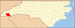 | |
| Unincorporated communities | ||
| Footnotes | ‡This populated place also has portions in an adjacent county or counties | |


| Authority control |
|
|---|