Boone, North Carolina
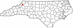
Boone is a town in and the county seat of Watauga County, North Carolina, United States. Located in the Blue Ridge Mountains of western North Carolina, Boone is the home of Appalachian State University. The population was 17,122 at the 2010 census.
Boone, North Carolina | |
|---|---|
| Town of Boone | |
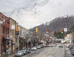 West King Street | |
 | |
| Coordinates: 36°12′41″N 81°40′7″W | |
| Country | United States |
| State | North Carolina |
| County | Watauga |
| Incorporated | 1872 |
| Named for | Daniel Boone |
| Government | |
| • Type | Council–manager |
| • Mayor | Rennie Brantz[1] |
| Area | |
| • Total | 6.07 sq mi (15.72 km2) |
| • Land | 6.07 sq mi (15.72 km2) |
| • Water | 0 sq mi (0 km2) |
| Elevation | 3,333 ft (1,015.9 m) |
| Population (2010) | |
| • Total | 17,122 |
| • Estimate (2019)[2] | 19,667 |
| • Density | 2,800/sq mi (1,100/km2) |
| Time zone | UTC−5 (Eastern (EST)) |
| • Summer (DST) | UTC−4 (EDT) |
| ZIP codes | 28607-28608 |
| Area code(s) | 828 |
| FIPS code | 37-07080[3] |
| GNIS feature ID | 1009539[4] |
| Website | http://www.townofboone.net |
The town is named for famous American pioneer and explorer Daniel Boone, and every summer since 1952 has hosted an outdoor amphitheatre drama, Horn in the West, portraying the British settlement of the area during the American Revolutionary War and featuring the contributions of its namesake. It is the largest community and the economic hub of the seven-county region of Western North Carolina known as the High Country.
About

Boone took its name from the famous pioneer and explorer Daniel Boone, who on several occasions camped at a site generally agreed to be within the present city limits. Daniel's nephews, Jesse and Jonathan (sons of brother Israel Boone), were members of the town's first church,[5] Three Forks Baptist, still in existence today.[6]
Boone was served by the narrow gauge East Tennessee and Western North Carolina Railroad (nicknamed "Tweetsie") until the flood of 1940. The flood washed away much of the tracks and it was decided not to replace them.
Boone is the home of Appalachian State University, a constituent member of the University of North Carolina. Appalachian State is the sixth-largest university in the seventeen-campus system. Caldwell Community College & Technical Institute also operates a satellite campus in Boone.
"Horn in the West" is a dramatization of the life and times of the early settlers of the mountain area. It features Daniel Boone as one of its characters, and has been performed in an outdoor amphitheater near the town every summer since 1952. The original actor in the role of "Daniel Boone" was Ned Austin. His "Hollywood Star" stands on a pedestal on King Street in downtown Boone. He was followed in the role by Glenn Causey, who portrayed the rugged frontiersman for 41 years, and whose image is still seen in many of the depictions of Boone featured in the area today.
Boone is notable for being home to the Junaluska community. Located in the hills just north of Downtown Boone, a free black community has existed in the area since before the Civil War. Although integration in the mid-20th century led to many of the businesses in the neighborhood closing in favor of their downtown counterparts, descendants of the original inhabitants still live in the neighborhood. Junaluska is also home to one of the few majority-African American Mennonite Brethren congregations.[7]
Boone is a center for bluegrass musicians and Appalachian storytellers. Notable artists associated with Boone include the late Grammy Award-winning bluegrass guitar player Doc Watson, and the late guitarist Michael Houser, one of the founding members of and the lead guitarist for the band Widespread Panic, as well as Old Crow Medicine Show, The Blue Rags, and Eric Church, all who are Boone natives.
The Blair Farm, Daniel Boone Hotel, Jones House, John Smith Miller House, and US Post Office-Boone are listed on the National Register of Historic Places.[8]
Geography and climate
Boone is located at 36°12′41″N 81°40′7″W (36.211364, −81.668657)[9] and has an elevation of 3,333 feet (1015.9 m) above sea level. An earlier survey gave the elevation as 3,332 ft and since then it has been published as having an elevation of 3,333 ft (1,016 m). Boone has the highest elevation of any town of its size (over 10,000 population) east of the Mississippi River. As such, Boone features, depending on the isotherm used, a humid continental climate (Köppen Dfb), a rarity for the Southeastern United States, bordering on a subtropical highland climate (Cfb) and straddles the boundary between USDA Plant Hardiness Zones 6B and 7A;[10] the elevation also results in enhanced precipitation, with 52.7 inches (1,340 mm) of average annual precipitation. Compared to the lower elevations of the Carolinas, winters are long and cold, with frequent sleet and snowfall. The daily average temperature in January is 31.2 °F (−0.4 °C),[11] which gives Boone a winter climate more similar to coastal southern New England rather than the Southeast, where a humid subtropical climate predominates. Blizzard-like conditions are not unusual during many winters. Summers are warm, but far cooler and less humid than lower regions to the south and east, with a July daily average temperature of 68.5 °F (20.3 °C).[11] Boone typically receives on average nearly 35 inches (89 cm) of snowfall annually, far higher than the lowland areas in the rest of North Carolina. On January 18, 1966, the temperature fell to −18 °F (−28 °C).[12]
| Climate data for Boone, 1981-2010 normals, extremes 1980-present | |||||||||||||
|---|---|---|---|---|---|---|---|---|---|---|---|---|---|
| Month | Jan | Feb | Mar | Apr | May | Jun | Jul | Aug | Sep | Oct | Nov | Dec | Year |
| Record high °F (°C) | 70 (21) |
72 (22) |
79 (26) |
85 (29) |
85 (29) |
91 (33) |
93 (34) |
91 (33) |
86 (30) |
86 (30) |
76 (24) |
72 (22) |
93 (34) |
| Mean maximum °F (°C) | 59 (15) |
63 (17) |
70 (21) |
76 (24) |
80 (27) |
83 (28) |
85 (29) |
84 (29) |
81 (27) |
75 (24) |
69 (21) |
62 (17) |
86 (30) |
| Average high °F (°C) | 41.6 (5.3) |
44.6 (7.0) |
52.2 (11.2) |
61.3 (16.3) |
69.3 (20.7) |
75.9 (24.4) |
78.9 (26.1) |
78.1 (25.6) |
72.1 (22.3) |
63.2 (17.3) |
54.2 (12.3) |
44.5 (6.9) |
61.4 (16.3) |
| Daily mean °F (°C) | 31.2 (−0.4) |
33.9 (1.1) |
40.7 (4.8) |
49.3 (9.6) |
57.7 (14.3) |
65.0 (18.3) |
68.5 (20.3) |
67.5 (19.7) |
61.1 (16.2) |
51.4 (10.8) |
42.7 (5.9) |
34.1 (1.2) |
50.3 (10.2) |
| Average low °F (°C) | 20.7 (−6.3) |
23.2 (−4.9) |
29.2 (−1.6) |
37.3 (2.9) |
46.1 (7.8) |
54.1 (12.3) |
58.1 (14.5) |
56.8 (13.8) |
50.1 (10.1) |
39.5 (4.2) |
31.1 (−0.5) |
23.7 (−4.6) |
39.2 (4.0) |
| Mean minimum °F (°C) | 2 (−17) |
8 (−13) |
14 (−10) |
23 (−5) |
33 (1) |
44 (7) |
50 (10) |
49 (9) |
38 (3) |
27 (−3) |
18 (−8) |
8 (−13) |
−1 (−18) |
| Record low °F (°C) | −24 (−31) |
−8 (−22) |
−6 (−21) |
14 (−10) |
26 (−3) |
36 (2) |
40 (4) |
38 (3) |
30 (−1) |
18 (−8) |
10 (−12) |
−11 (−24) |
−24 (−31) |
| Average precipitation inches (mm) | 3.78 (96) |
3.92 (100) |
4.75 (121) |
4.47 (114) |
4.43 (113) |
5.10 (130) |
5.00 (127) |
5.10 (130) |
4.44 (113) |
3.59 (91) |
4.47 (114) |
3.69 (94) |
52.73 (1,339) |
| Average snowfall inches (cm) | 10.3 (26) |
9.0 (23) |
4.3 (11) |
2.9 (7.4) |
0.1 (0.25) |
0 (0) |
0 (0) |
0 (0) |
0 (0) |
0.1 (0.25) |
1.3 (3.3) |
6.7 (17) |
34.6 (88) |
| Average precipitation days (≥ 0.01 in) | 11.4 | 11.0 | 11.6 | 12.0 | 13.3 | 13.5 | 13.5 | 12.6 | 10.0 | 9.1 | 9.7 | 11.3 | 139.0 |
| Average snowy days (≥ 0.1 in) | 4.5 | 4.0 | 2.2 | 1.3 | 0 | 0 | 0 | 0 | 0 | 0.1 | 0.8 | 3.2 | 16.2 |
| Source: NOAA[11] | |||||||||||||
| Climate data for Boone, extremes 1920-1980 | |||||||||||||
|---|---|---|---|---|---|---|---|---|---|---|---|---|---|
| Month | Jan | Feb | Mar | Apr | May | Jun | Jul | Aug | Sep | Oct | Nov | Dec | Year |
| Record high °F (°C) | 78 (26) |
75 (24) |
80 (27) |
89 (32) |
86 (30) |
94 (34) |
96 (36) |
91 (33) |
92 (33) |
87 (31) |
80 (27) |
73 (23) |
96 (36) |
| Mean maximum °F (°C) | 61.1 (16.2) |
62.8 (17.1) |
70.0 (21.1) |
77.6 (25.3) |
80.8 (27.1) |
84.8 (29.3) |
85.9 (29.9) |
84.6 (29.2) |
82.3 (27.9) |
75.7 (24.3) |
69.4 (20.8) |
61.4 (16.3) |
87.8 (31.0) |
| Mean minimum °F (°C) | 3.3 (−15.9) |
5.7 (−14.6) |
12.9 (−10.6) |
23.4 (−4.8) |
32.8 (0.4) |
41.2 (5.1) |
48.1 (8.9) |
45.5 (7.5) |
36.2 (2.3) |
24.2 (−4.3) |
13.1 (−10.5) |
5.5 (−14.7) |
−2.5 (−19.2) |
| Record low °F (°C) | −18 (−28) |
−8 (−22) |
−1 (−18) |
13 (−11) |
24 (−4) |
33 (1) |
38 (3) |
33 (1) |
25 (−4) |
14 (−10) |
−6 (−21) |
−10 (−23) |
−18 (−28) |
| Source: WRCC[12] | |||||||||||||
Demographics
| Historical population | |||
|---|---|---|---|
| Census | Pop. | %± | |
| 1880 | 167 | — | |
| 1890 | 144 | −13.8% | |
| 1900 | 155 | 7.6% | |
| 1910 | 179 | 15.5% | |
| 1920 | 374 | 108.9% | |
| 1930 | 1,295 | 246.3% | |
| 1940 | 1,788 | 38.1% | |
| 1950 | 2,973 | 66.3% | |
| 1960 | 3,686 | 24.0% | |
| 1970 | 8,754 | 137.5% | |
| 1980 | 10,191 | 16.4% | |
| 1990 | 12,915 | 26.7% | |
| 2000 | 13,472 | 4.3% | |
| 2010 | 17,122 | 27.1% | |
| Est. 2019 | 19,667 | [2] | 14.9% |
| U.S. Decennial Census[13] | |||
As of the census[3] of 2000, there were 13,472 people, 4,374 households, and 1,237 families residing in the town. The population density was 2,307.0 people per square mile (890.7/km²). There were 4,748 housing units at an average density of 813.0 per square mile (313.9/km²). The racial makeup of the town was 93.98% White, 3.42% Black or African American, 0.30% Native American, 1.19% Asian, 0.05% Pacific Islander, 0.46% from other races, and 0.60% from two or more races. 1.64% of the population were Hispanic or Latino of any race.[3]
There were 4,374 households out of which 9.6% had children under the age of 18 living with them, 21.0% were married couples living together, 5.6% had a female householder with no husband present, and 71.7% were non-families. 38.4% of all households were made up of individuals and 7.3% had someone living alone who was 65 years of age or older. The average household size was 1.97 and the average family size was 2.63.[3]
In the town, the population was spread out with 5.8% under 18, 65.9% from 18 to 24, 12.1% from 25 to 44, 9.1% from 45 to 64, and 7.1% who were 65 or older. The median age was 21 years. For every 100 females, there are 95.6 males. For every 100 females age 18 and over, there were 94.7 males.[3]
The median income for a household in the town was $20,541, and the median income for a family was $49,762. The per capita income was $12,256. Males had a median income of $28,060 versus $20,000 for females. About 9.2% of families and 37.0% of the population were below the poverty line, including 6.3% of those under the age of 18 and 9.1% of those 65 and older.[3]
Media
Newspaper
Boone is mainly served by three local newspapers:
- The Watauga Democrat is published on Wednesdays and Sundays.[14]
- The Mountain Times (free weekly entertainment publication).
- The High Country Press (daily online news publication).
A smaller newspaper, The Appalachian, is Appalachian State University's campus newspaper; it is published once a week on Thursdays. In addition to the locally printed papers, a monthly entertainment pamphlet named Kraut Creek Revival has limited circulation and is funded by a Denver, NC-based newspaper.
Radio
- WATA-AM 1450 AM is predominantly news talk.
- WZJS-FM 100.7 FM is an oldies radio station.
- WMMY-FM 106.1 FM is a country music radio station, broadcasting the same as 102.3 ("Highway 106/102-3").
- WWMY 102.3 FM is a country music radio station, broadcasting the same as 106.1 ("Highway 106/102-3").
- WECR 1130 AM is primarily a Gospel music and local news station.
- WXIT-AM 1200 AM is predominantly Conservative talk radio.
- WASU 90.5 FM is a college radio station run from the Appalachian State University campus.
- WNCW 92.9 FM NPR Affiliate a noncommercial public radio station licensed to Isothermal Community College.
- WFDD 88.5 FM NPR Affiliate a noncommercial public radio station from Wake Forest University broadcasts an additional signal for the North Carolina High Country at 100.1 FM[15]
Law and government
Boone operates under a mayor–council government. The city council consists of five members. The mayor presides over the council and casts a vote on issues only in the event of a tie. As of December 2015, the Town Council members were: Rennie Brantz, Mayor, and Councilors: Lynne Mason (Mayor Pro-Tem), Jennifer Teague, Loretta Clawson, Charlotte Mizelle and Jeannine Underdown Collins.
Development
Industrial, commercial, and residential development in the town of Boone is a controversial issue due to its location in the mountains of Appalachia. On October 16, 2009, the town council accepted the "Boone 2030 Land Use Plan."[16] While the document itself is not in any way actual law, it is used by the town council, board of adjustment, and other committees to guide decision making as to what types of development are appropriate.[17]
In 2009, the North Carolina Department of Transportation began widening 1.1 miles of U.S. 421 (King Street) to a 4-to-6-lane divided highway with a raised concrete median from U.S. 321 (Hardin Street) to east of N.C. 194 (Jefferson Road), including a new entrance and exit to the new Watauga High School, at a cost of $16.2 million.[18] The widening has displaced 25 businesses and 63 residences east of historic downtown King Street.[19] The project was slated to be completed by December 31, 2011, but construction continued into the spring of 2012.
Points of interest
Notable residents

- Sam Adams, professional golfer who played on the PGA Tour[20]
- Chris Austin, country music singer[21]
- Eustace Conway, an American naturalist
- Rufus L. Edmisten, former North Carolina Secretary of State and Attorney General[22]
- Tommy Gregg, former MLB player[23]
- Steve Goss, former North Carolina Senator and ordained Southern Baptist minister[24]
- Doc Hendley, founder of Wine to Water, an American charitable organization
- John Hollar, former NFL player for the Washington Redskins and Detroit Lions[25]
- James Holshouser, was the 68th Governor of North Carolina
- Michael Houser, founding member and lead guitarist of the band Widespread Panic
- Ken Isaacs, executive with the Christian organization Samaritan's Purse[26]
- Ryder Jones, MLB player with the San Francisco Giants[27]
- Bob Matheson, former NFL player and 2x Super Bowl champion with the Miami Dolphins
- Abraham Morlu, former CFL player and track Olympian, representing his birth country Liberia[28]
- Stanley South, major proponent of the processual archaeology movement
- Brenda Taylor, Olympic hurdler who represented the USA at the 2004 Athens Olympics[28]
- Coaker Triplett, former MLB player for the Chicago Cubs, St. Louis Cardinals, and Philadelphia Phillies[29]
- Doc Watson, bluegrass, gospel, blues, folk, and country singer
Sister city
.svg.png)
References
- "Archived copy". Archived from the original on August 6, 2015. Retrieved July 31, 2015.CS1 maint: archived copy as title (link)
- "Population and Housing Unit Estimates". Retrieved May 21, 2020.
- "U.S. Census website". United States Census Bureau. Retrieved January 31, 2008.
- "US Board on Geographic Names". United States Geological Survey. October 25, 2007. Retrieved January 31, 2008.
- "Philosophy of Ministry". Three Forks Baptist Church. Archived from the original on May 30, 2016. Retrieved January 13, 2017.
- Arthur, John Preston (1915). A History of Watauga County, North Carolina. Richmond: Everett Waddey Co. p. 30. Retrieved January 13, 2017.
- https://www.ourstate.com/junaluska/
- "National Register Information System". National Register of Historic Places. National Park Service. July 9, 2010.
- "US Gazetteer files: 2010, 2000, and 1990". United States Census Bureau. February 12, 2011. Retrieved April 23, 2011.
- "What is my arborday.org Hardiness Zone?". Arborday.org. Retrieved July 14, 2017.
- "NOWData – NOAA Online Weather Data". National Oceanic and Atmospheric Administration. Retrieved December 4, 2012.
- "BOONE, NORTH CAROLINA – Climate Summary". wrcc.dri.edu. Retrieved August 7, 2018.
- "Census of Population and Housing". Census.gov. Retrieved June 4, 2015.
- "About Us | Site". Wataugademocrat.com. Retrieved July 14, 2017.
- "WFDD in the High Country on 100.1". WFDD.org. Retrieved October 19, 2015.
- "Boone2030Blogspot". TownOfBoone. Retrieved October 31, 2010.
- "Boone 2030 Land Use Plan PDF" (PDF). Lawrence Group. Archived from the original (PDF) on July 17, 2011. Retrieved October 31, 2010.
- "NC DOT US421 Widening Project". NCDOT. Archived from the original on July 31, 2009. Retrieved October 31, 2010.
- "statedotpaves". Wataugademocrat.com. March 16, 2007. Archived from the original on September 18, 2012. Retrieved August 9, 2009.
- Sam Adams - Tournament Results | Tennessee PGA. PGA Tennessee Section. Retrieved 20 May 2019.
- Chris Austin | country music singer | MerleFest | Blue Ridge National Heritage Area. Blue Ridge National Heritage Area. Retrieved 20 May 2019.
- RUFUS L. EDMISTEN - Carolinas Boxing Hall of Fame. Carolinas Boxing Hall of Fame. Retrieved 20 May 2019.
- http://www.thebaseballcube.com/players/profile.asp?ID=12149. The Baseball Cube. Retrieved November 15, 2018.
- Former Senator Steve Goss dies at 65. Watauga Democrat. Retrieved 20 May 2019.
- https://www.pro-football-reference.com/players/H/HollJo21.htm. Pro Football Reference. Retrieved November 15, 2018.
- Lucas, Fred. March 29, 2018. Backers of Trump Pick for UN Migration Agency Counter Media Attacks. The Daily Signal. Retrieved 20 May 2019.
- Ryder Jones Profile. The Baseball Cube. Retrieved 20 March 2019.
- NCPrepTrack.com. Retrieved 21 March 2019.
- http://www.thebaseballcube.com/players/profile.asp?ID=19016. The Baseball Cube. Retrieved November 15, 2018.
- "About Sister Cities | Town of Collingwood". www.collingwood.ca. Archived from the original on February 28, 2018. Retrieved March 20, 2019.
External links
| Wikivoyage has a travel guide for Boone (North Carolina). |
- Official website
- DigitalNC: Historic Boone
- Historical Boone Photos, Postcards, and Paper
- Cy Crumley ET&WNC Photo Collection
Municipalities and communities of Watauga County, North Carolina, United States | ||
|---|---|---|
| Towns | 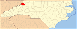 Watauga County map | |
| CDPs | ||
| Unincorporated communities |
| |
| Footnotes | ‡This populated place also has portions in an adjacent county or counties | |


| Authority control |
|
|---|